Mount Johnson (California)

Last updated
Mount Johnson
Mts. Johnson and Gilbert.jpg
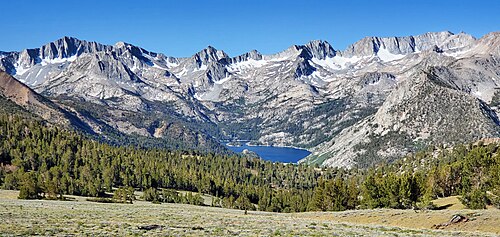
North aspect, upper left
(Mt. Gilbert on right, South Lake below)
Highest point
Elevation 12,871 ft (3,923 m) [1]
Prominence 511 ft (156 m) [1]
Parent peak Mount Gilbert (13,106 ft) [2]
Isolation 0.88 mi (1.42 km) [2]
Listing Sierra Peaks Section
Coordinates 37°07′42″N118°35′11″W / 37.1284588°N 118.5863576°W / 37.1284588; -118.5863576 Coordinates: 37°07′42″N118°35′11″W / 37.1284588°N 118.5863576°W / 37.1284588; -118.5863576 [3]
Naming
Etymology Willard Drake Johnson
Geography
Relief map of California.png
Red triangle with thick white border.svg
Mount Johnson
Location in California
Usa edcp relief location map.png
Red triangle with thick white border.svg
Mount Johnson
Mount Johnson (the United States)
Location Kings Canyon National Park
Fresno County / Inyo County
California, U.S.
Parent range Sierra Nevada [1]
Topo map USGS Mount Thompson
Geology
Age of rock Cretaceous
Mountain type Fault block
Type of rock granitic
Climbing
First ascent < 1939
Easiest route class 2 [2] Southeast slope

Mount Johnson is a 12,871-foot-elevation (3,923 meter) mountain summit located on the crest of the Sierra Nevada mountain range in California, United States. [3] It is situated on the shared boundary of Kings Canyon National Park with John Muir Wilderness, and along the common border of Fresno County with Inyo County. It is also 18 miles (29 km) west of the community of Big Pine, 0.9 mile (1.4 km) southeast of Mount Gilbert, and one mile (1.6 km) west-northwest of Mount Goode. Mount Johnson ranks as the 187th-highest summit in California. [2] Topographic relief is significant as the southwest aspect rises 3,670 feet (1,120 meters) above LeConte Canyon in 1.5 mile, and the north aspect rises 3,100 feet above South Lake in 2.5 miles.

Contents

History

This mountain's name and location was proposed by the Sierra Club to honor Willard Drake Johnson (1859–1917), a geologist and topographer with the U. S. Geological Survey. [4] The mountain's name was officially adopted in 1926 by the U.S. Board on Geographic Names. [3] It is in the vicinity of other mountains named for distinguished members of the early U. S. Geological Survey, i.e. Mount Powell, Mount Gilbert, Mount Thompson, and Mount Goode.

Sierra Club member Jack Sturgeon climbed the peak August 14, 1939, by way of the western arête, and reported that the peak had previously been climbed twice by Norman Clyde, who is credited with 130 first ascents, most of which were in the Sierra Nevada. [5] Clyde made the first ascent of nearby Mt. Gilbert in 1928, possibly climbing Johnson around the same time.

Climbing

Established climbing routes: [6]

Climate

Mount Johnson is located in an alpine climate zone. [7] Most weather fronts originate in the Pacific Ocean, and travel east toward the Sierra Nevada mountains. As fronts approach, they are forced upward by the peaks, causing them to drop their moisture in the form of rain or snowfall onto the range (orographic lift). Precipitation runoff from this mountain drains south into the Middle Fork Kings River, and north into Bishop Creek.

See also

View from Coyote Ridge, left to right: Mts. Goode, Johnson, Gilbert, Thompson Goode, Johnson, Gilbert, Thompson.jpg
View from Coyote Ridge, left to right: Mts. Goode, Johnson, Gilbert, Thompson

Related Research Articles

Mount Tyndall

Mount Tyndall is a peak in the Mount Whitney region of the Sierra Nevada in the U.S. state of California. It rises to 14,025 feet (4,275 m), and is the tenth highest peak in the state. The mountain was named in honor of the Irish scientist and mountaineer, John Tyndall.

Mount McAdie

Mount McAdie is a summit on the crest of the Sierra Nevada, and is located 2.1 miles (3.4 km) south of Mount Whitney. It has three summits, with the north peak being the highest. The summit ridge marks the boundary between Sequoia National Park and the John Muir Wilderness. It is also on the boundary between Inyo and Tulare counties. Lone Pine, 12.4 miles (20.0 km) to the northeast, is in the Owens Valley on U.S. 395.

Mount Goode (California)

Mount Goode is a 13,085-foot-elevation mountain summit located on the crest of the Sierra Nevada mountain range in California, United States. It is situated on the shared boundary of Kings Canyon National Park with John Muir Wilderness, and along the common border of Fresno County with Inyo County. It is also approximately one mile west-northwest of Bishop Pass, one mile east-southeast of Mount Johnson, 1.23 miles (1.98 km) south of Hurd Peak, and 16 miles (26 km) west of the community of Big Pine.

Mount Thompson (California)

Mount Thompson is a 13,494-foot-elevation mountain summit located on the crest of the Sierra Nevada mountain range in California, United States. It is situated on the shared boundary of Kings Canyon National Park with John Muir Wilderness, and along the common border of Fresno County with Inyo County. It is also 18 miles (29 km) west of the community of Big Pine, one mile northwest of Mount Gilbert, and three miles east of Mount Fiske, which is the nearest higher neighbor. Mount Thompson ranks as the 62nd-highest summit in California. This mountain's name commemorates Almon Harris Thompson (1839–1906). The first ascent of the peak was made by Clarence H. Rhudy and H. F. Katzenbach in the summer of 1909.

Mount Fiske

Mount Fiske is a 13,503-foot-elevation mountain summit located near the crest of the Sierra Nevada mountain range, in Fresno County of northern California, United States. It is situated in northern Kings Canyon National Park, 23 miles (37 km) west of the community of Big Pine, 0.83 miles (1.34 km) east of Mount Huxley, and two miles south of Mount Darwin, which is the nearest higher neighbor. Mount Fiske ranks as the 60th highest summit in California.

Black Giant

Black Giant is a 13,330-foot-elevation mountain summit located near the crest of the Sierra Nevada mountain range, in Fresno County of northern California, United States. Black Giant ranks as the 86th highest summit in California. It is situated in northern Kings Canyon National Park, 21 miles (34 km) west-southwest of the community of Big Pine, 3.6 miles (5.8 km) southwest of Mount Thompson, and 2.6 miles (4.2 km) south-southeast of Mount Fiske, which is the nearest higher neighbor. Topographic relief is significant as it rises 4,000 feet (1,220 meters) above LeConte Canyon in approximately two miles. Muir Pass is 1.5 miles (2.4 km) to the northwest, and the approach to this remote peak is made via the John Muir Trail.

Langille Peak

Langille Peak is a 12,018-foot-elevation mountain summit located near the crest of the Sierra Nevada mountain range, in Fresno County of northern California, United States. It is situated in northern Kings Canyon National Park, 19 miles (31 km) west-southwest of the community of Big Pine, 3 miles (4.8 km) south of Mount Thompson, 2.8 miles (4.5 km) southwest of Mount Goode, and 2.1 miles (3.4 km) east of Black Giant. Topographic relief is significant as the east aspect rises 3,100 feet (945 meters) above LeConte Canyon in less than one mile. The approach to this remote peak is made via the John Muir Trail.

Mount Gayley

Mount Gayley is a 13,510-foot-elevation mountain summit located one mile east of the crest of the Sierra Nevada mountain range in Inyo County, California, United States. It is situated in the Palisades area of the John Muir Wilderness, on land managed by Inyo National Forest. It is approximately 13 miles (21 km) west-southwest of the community of Big Pine, 0.67 miles (1.08 km) southwest of Temple Crag, and 0.5 miles (0.80 km) north-northeast of parent Mount Sill. Mount Gayley ranks as the 59th highest summit in California.

Mount Haeckel

Mount Haeckel is a 13,418-foot-elevation mountain summit located on the crest of the Sierra Nevada mountain range in northern California, United States. It is situated on the shared boundary of Kings Canyon National Park with John Muir Wilderness, and along the common border of Fresno County with Inyo County. It is 21.5 miles (34.6 km) west of the community of Big Pine, 1.27 miles (2.04 km) south-southeast of Mount Darwin, and one mile north-northeast of Mount Fiske, which is the nearest higher neighbor. Mount Haeckel ranks as the 71st highest summit in California.

North Guard

North Guard is a remote 13,327-foot-elevation mountain summit located near the northern end of the Great Western Divide of the Sierra Nevada mountain range, in Tulare County of northern California. It is situated in Kings Canyon National Park, 0.9 miles (1.4 km) southeast of Mount Farquhar, and 0.6 miles (0.97 km) north-northwest of Mount Brewer, which is the nearest higher neighbor. Topographic relief is significant as the east aspect rises 3,858 feet (1,176 meters) above East Lake in three miles. North Guard ranks as the 87th highest summit in California, and the second highest point of the northern Great Western Divide. It's not as high as Mount Brewer, but offers better climbing and is considered one of the classic climbing routes in the Sierra Nevada.

Mount Perkins (California)

Mount Perkins is a 12,566-foot-elevation mountain summit located on the crest of the Sierra Nevada mountain range in northern California. It is situated on the common border of Fresno County with Inyo County, as well as the shared boundary of John Muir Wilderness and Kings Canyon National Park. It is 13.5 miles (21.7 km) northwest of the community of Independence, 1.65 miles (2.66 km) north of Mount Cedric Wright, 2.2 miles (3.5 km) east of Crater Mountain, and 1.4 miles (2.3 km) southeast of Mount Wynne. Climbing routes to the summit include the west slope, and the north and south ridges. The John Muir Trail traverses below the west base of this peak, providing an approach to the mountain.

The Hermit (California mountain)

The Hermit is a 12,328-foot-elevation mountain summit located west of the crest of the Sierra Nevada mountain range, in Fresno County of northern California, United States. It is situated in northern Kings Canyon National Park, 2.5 miles (4.0 km) east of Emerald Peak, and 2.5 miles (4.0 km) west of Mount Darwin. Topographic relief is significant as the north aspect rises 2,500 feet (762 meters) above Evolution Valley in less than one mile. The John Muir Trail passes to the east and north of this landmark, providing an approach. This geographical feature was named by Sierra Club explorer Theodore Solomons in 1895 as he wrote: "The traveler will be greatly attracted by a very sharp peak or butte that rises on the south wall. From its isolated position as viewed from the valley we called it the Hermit."

Thor Peak (California)

Thor Peak is a 12,306-foot-elevation (3,751 meter) mountain summit located east of the crest of the Sierra Nevada mountain range in Inyo County, California. It is situated in the John Muir Wilderness on land managed by Inyo National Forest. It is 12.5 miles (20.1 km) west of the community of Lone Pine, and 1.5 mile east of Mount Whitney. Topographic relief is significant as it rises 3,937 feet (1,200 meters) above Whitney Portal in 1.5 mile. Hikers on the Mount Whitney Trail pass below the impressive south face of the peak.

Mount Carillon

Mount Carillon is a 13,553-foot-elevation (4,131 meter) mountain summit located on the crest of the Sierra Nevada mountain range in California. It is situated on the common border of Tulare County with Inyo County, as well as the shared boundary of Sequoia National Park and John Muir Wilderness. It is set above the south shore of Tulainyo Lake, 12.5 miles (20.1 km) west of the community of Lone Pine, 1.25 mile (2.0 km) northeast of Mount Whitney, and 0.7 mile (1.1 km) east-northeast of Mount Russell, the nearest higher neighbor. Topographic relief is significant as it rises approximately 5,180 feet (1,580 meters) above Whitney Portal in approximately two miles. Carillon has subpeaks, unofficially called "The Cleaver", 0.4 mile to the northeast, and "Impala", on the southeast ridge.

Mount Lamarck

Mount Lamarck is a 13,417-foot-elevation mountain summit located on the crest of the Sierra Nevada mountain range in northern California, United States. It is situated on the shared boundary of Kings Canyon National Park with John Muir Wilderness, and along the common border of Fresno County with Inyo County. It is 20 miles (32 km) southwest of the community of Bishop, and 1.9 miles (3.1 km) north of Mount Darwin. Subsidiary peak Mount Lamarck North ranks as the 67th highest summit in California, and the sixth highest in the Evolution Region. Topographic relief is significant as the east aspect rises 4,290 feet (1,307 meters) above Lake Sabrina in three miles, and the west aspect rises 3,600 feet (1,097 meters) above Evolution Valley in three miles.

Mount Genevra

Mount Genevra is a remote 13,054-foot-elevation mountain summit located on the Kings–Kern Divide of the Sierra Nevada mountain range, in Tulare County of northern California. It is situated on the shared boundary of Kings Canyon National Park with Sequoia National Park, 3.5 miles (5.6 km) southeast of Mount Brewer, and 0.86 miles (1.38 km) east of Mount Jordan, which is the nearest higher neighbor. Topographic relief is significant as the north aspect rises 3,025 feet (922 meters) above Lake Reflection in 1.5 mile. Mount Genevra ranks as the 138th highest summit in California, and the eighth highest peak on the Kings–Kern Divide.

Mount Jordan

Mount Jordan is a remote 13,343-foot-elevation mountain summit located on the Kings–Kern Divide of the Sierra Nevada mountain range, in Tulare County of northern California. It is situated on the shared boundary of Kings Canyon National Park with Sequoia National Park, 3.1 miles (5.0 km) southwest of Mount Stanford, and one mile west of Mount Genevra, which is the nearest neighbor. Topographic relief is significant as the north aspect rises 3,313 feet (1,010 meters) above Lake Reflection in 1.3 mile. Mount Jordan ranks as the 84th highest summit in California, and the fifth-highest peak on the Kings–Kern Divide.

South Guard

South Guard is a remote 13,232-foot-elevation mountain summit located near the northern end of the Great Western Divide of the Sierra Nevada mountain range, in Tulare County of northern California. It is situated in Kings Canyon National Park, 1.63 miles (2.62 km) south of North Guard, and one mile south of Mount Brewer, which is the nearest higher neighbor. Topographic relief is significant as the west aspect rises 4,600 feet (1,400 meters) above Cloud Canyon in 3.5 miles, and the east aspect rises 3,200 feet (976 meters) above Lake Reflection in two miles. South Guard ranks as the 103rd highest summit in California, and the third-highest point of the northern Great Western Divide.

Mount Gilbert (California)

Mount Gilbert is a 13,106-foot-elevation mountain summit located on the crest of the Sierra Nevada mountain range in California, United States. It is situated on the shared boundary of Kings Canyon National Park with John Muir Wilderness, and along the common border of Fresno County with Inyo County. It is also 18 miles (29 km) west of the community of Big Pine, 0.8 mile northwest of Mount Johnson, and one mile southeast of Mount Thompson, which is the nearest higher neighbor. Mount Gilbert ranks as the 127th-highest summit in California. Topographic relief is significant as the south aspect rises 3,900 feet (1,190 meters) above LeConte Canyon in less than two miles, and the north aspect rises 3,340 feet above South Lake in 2.5 miles.

Mount Wallace (Fresno and Inyo counties, California)

Mount Wallace is a 13,377-foot-elevation mountain summit located on the crest of the Sierra Nevada mountain range in northern California, United States. It is situated on the shared boundary of Kings Canyon National Park with John Muir Wilderness, and along the common border of Fresno County with Inyo County. It is 21 miles (34 km) west of the community of Big Pine, 1.38 miles (2.22 km) northwest of Mount Powell, 0.5 miles (0.80 km) southwest of Picture Peak, and 0.37 miles (0.60 km) southeast of Mount Haeckel, which is the nearest higher neighbor. Mount Wallace ranks as the 79th-highest summit in California, and the ninth-highest in the Evolution Region.

References

  1. 1 2 3 "Mount Johnson, California". Peakbagger.com. Retrieved 2021-06-11.
  2. 1 2 3 4 "Johnson, Mount - 12,871' CA". listsofjohn.com. Retrieved 2021-06-11.
  3. 1 2 3 "Mount Johnson". Geographic Names Information System . United States Geological Survey . Retrieved 2021-06-11.
  4. Francis P. Farquhar, Place Names of the High Sierra (1926)
  5. Alan M. Hedden and David R. Brower, A Climber's Guide to the High Sierra (1954)
  6. R. J. Secor, The High Sierra Peaks, Passes, Trails, 2009, Third Edition, Mountaineers Books, ISBN   9780898869712, page 285.
  7. "Climate of the Sierra Nevada". Encyclopædia Britannica .