Black Moshannon State Park Historic Districts

Last updated

Map of Black Moshannon State Park with the outlines of the three Historic Districts shown in red and buildings in black Black Moshannon SP Historic Districts Map.png
Map of Black Moshannon State Park with the outlines of the three Historic Districts shown in red and buildings in black

The Black Moshannon State Park Historic Districts are three separate historic districts on the National Register of Historic Places (NRHP) at Black Moshannon State Park in Rush Township, Centre County, Pennsylvania in the United States. The structures in the historic districts were constructed in the 1930s during the Great Depression by the Civilian Conservation Corps (CCC). The three districts are: the Beach and Day Use District, with 18 contributing structures, including 11 different picnic pavilions, concession building, bathhouse, museum, and four open pit latrines; the Family Cabin District with 16 contributing properties, including 13 cabins, one lodge and two latrines; and the Maintenance District with four contributing properties, including a storage building, three-bay garage, gas pump house, and ranger's residence.

Contents

Beaver Meadow CCC Camp S-71, near Philipsburg was home to CCC Company 359, which built the structures in the three historic districts between 1933 and 1937. Black Moshannon State Park opened in 1937, and over the years some of the CCC-built structures have been lost or replaced, including the dam that forms Black Moshannon Lake. Still, enough structures remained, and in good enough shape for the three historic districts to be added to the NRHP in 1987.

Background

Men of CCC Company 359 working on the dam in Black Moshannon State Park, c. 1936. CCC Company 359 Dam crop.PNG
Men of CCC Company 359 working on the dam in Black Moshannon State Park, c. 1936.

The CCC, founded by President Franklin D. Roosevelt, created many jobs for unemployed industrial workers from Altoona, Bellefonte and Tyrone. Black Moshannon State Park is just one of many examples of the work of the Civilian Conservation Corps throughout central Pennsylvania. [1] [2]

Beaver Meadow CCC Camp S-71 was built in May 1933 near the abandoned village of Beaver Mills, and was one of the first CCC camps built to expand recreational facilities in Pennsylvania. [3] Over 200 young men moved in and began the work of conserving soil, water and timber in the Black Moshannon area. They cut roads through the growing forest to aid in fighting the many wildfires that sprang up, and planted many acres of red pines as part of the reforestation effort. [4] The CCC also built many of the park facilities still in use today. They built log cabins, picnic pavilions, a food concession stand, and miles of trails. Early on the CCC constructed a dam at Black Moshannon Lake, on the site of the former mill pond dam. [1] [2] [5]

The CCC camp closed in January 1937 and Black Moshannon State Park opened that same year. In the 1950s the CCC-built dam was replaced by the current structure. [5] In 1987, the existing CCC structures in the park were placed on the National Register of Historic Places as part of three separate historic districts. [6] All three districts were built between 1933 and 1937 and are designated as the day use, family cabin and maintenance districts.

Beach and Day Use District

Pavilion 5 is a contributing property in the Beach and Day Use Historic District. Black Moshannon SP Picnic Shelter 5.jpg
Pavilion 5 is a contributing property in the Beach and Day Use Historic District.

Eighteen structures in the Beach and Day Use Historic District are contributing structures and are protected as historic places. [5] These structures include seven "standard" pavilions with pyramidal roofs and timber supports, a larger picnic shelter with a log railing and supports and a roof similar to those of the "standard" pavilions, and three water pump shelters. The water pump shelters were built of native stone and covered with pebbles, and have since been converted to picnic pavilions. The concession building, bathhouse, and museum are also protected. The concession building is a rectangular log building with saddle corners and a gabled roof with a cross gabled entryway. [5] The bathhouse is at the beach and was built with stone columns and a hip roof. The bathhouse walls consist of vertical wooden siding. The nature museum is a former stone and wood pavilion that is set into a dirt bank with stone walls. Four open pit latrines with wane edge siding and hipped roofs are also contributing structures to the Beach and Day Use Historic District. There are no non-contributing structures in the district. [5]

Family Cabin District

Rustic cabins 9, 10, and 11 have two rooms each and are part of the Family Cabin District. Black Moshannon State Park Cabins D.JPG
Rustic cabins 9, 10, and 11 have two rooms each and are part of the Family Cabin District.

The Family Cabin Historic District of Black Moshannon State Park consists of 16 contributing properties on 16.5 acres (6.7 ha): 13 cabins, one lodge and two latrines. Twelve of the cabins are laid out in a straight line along an access road, which is a design similar to that of motor courts of the 1930s. The design of the cabin layout at Black Moshannon State Park is unique compared to CCC-built cabins at other Pennsylvania state parks. [3] The cabins at the other parks reflect the "rustic" style of cabin layout promoted by the National Park Service.

Cabins 1 - 6 are single room log cabins with saddle corners and white cement chinking. They have gable entries and an exterior stone fireplace on the end opposite the entry. Cabins 7 - 12 are two-room log cabins with eave entries and stone fireplaces along the rear walls. The Lodge (also known as Cabin 13) is a large rectangular clapboard-sided building with a large centrally-located stone fireplace. Cabin 14 is an L-shaped cabin with an open porch; the stone fireplace forms one exterior wall, while the other walls are clapboard. [3] Two pit latrines built by the CCC are protected: both have shed roofs and are clapboard sided. [3]

Maintenance District

The storage building (left) and pump house (right) in the park Black Moshannon SP Maintenance and Pump House.jpg
The storage building (left) and pump house (right) in the park

The maintenance Historic District at Black Moshannon State Park comprises four CCC-built structures and covers 2.75 acres (1.11 ha) along Munson Road, in the northwest corner of the park. [7] The storage building is a wood-frame structure with gable roofs and clapboard siding. It is similar to storage buildings built by the military during the 1930s and 1940s. A three-bay garage of standard military design is included in this historic district. It is two stories high and has clapboard siding. The gas pump house has an extended eave to protect the gas pumps, and is also a standard military design. The ranger's residence is a 1+12-story gable-roofed house with a small addition on one end. It was-sided with aluminum siding at some point after the CCC built it. There is one non-contributing structure in the district: a Maintenance Shop built in 1978. [7]

Related Research Articles

<span class="mw-page-title-main">Petit Jean State Park</span> United States historic place

Petit Jean State Park is a 3,471-acre (1,405 ha) park in Conway County, Arkansas managed by the Arkansas Department of Parks and Tourism. It is located atop Petit Jean Mountain adjacent to the Arkansas River in the area between the Ouachita Mountains and Ozark Plateaus.

<span class="mw-page-title-main">Scenic State Park</span> State park in Minnesota, United States

Scenic State Park is a Minnesota state park near Bigfork in Itasca County. It encompasses 3,936 acres (1,593 ha) of virgin pine forests that surround Sandwick Lake and Coon Lake. It also includes portions of Lake of the Isles, Tell Lake, Cedar Lake, and Pine Lake. Established in 1921, the Ojibwe tribe had previously used the area for hunting. The park has places for camping, hiking, swimming, fishing, and canoeing.

<span class="mw-page-title-main">Bewabic State Park</span> Park in Michigan, USA

Bewabic State Park is a public recreation area covering 315 acres (127 ha) on the shore of Fortune Lake, four miles (6.4 km) west of Crystal Falls in Iron County, Michigan. The state park's rich Civilian Conservation Corps history is evidenced by the CCC structures still in use. The park was listed on the National Register of Historic Places for its CCC-related architecture in 2016.

<span class="mw-page-title-main">Hoeft State Park</span> Park in Michigan, USA

P. H. Hoeft State Park is a public recreation area on the shores of Lake Huron, four miles (6.4 km) northwest of Rogers City on US 23 in Presque Isle County, Michigan. The park was added to the National Register of Historic Places in 2009.

<span class="mw-page-title-main">Onaway State Park</span> Park in Michigan, USA

Onaway State Park is a public recreation area covering 158 acres (64 ha) on the southeast shore of Black Lake in North Allis Township, Presque Isle County, Michigan. The state parks sits at the end of M-211 five miles north of Onaway. It contains sand and cobblestone beaches, large rock outcroppings, a campground, and nature trail highlighting a diversity of trees. The park was added to the National Register of Historic Places in 2009.

<span class="mw-page-title-main">Wells State Park (Michigan)</span> Park in Michigan, USA

J.W. Wells State Park is a state park in the U.S. state of Michigan. The 678-acre (2.74 km2) park is located in Menominee County on the shore of Lake Michigan's Green Bay, just south of Cedar River. It is on M-35, roughly midway between Menominee and Escanaba. It was added to the National Register of Historic Places in 2002.

<span class="mw-page-title-main">Bennett Spring State Park</span> State park of Missouri

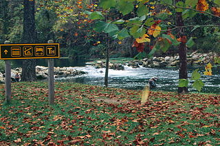
Bennett Spring State Park is a public recreation area located in Bennett Springs, Missouri, twelve miles (19 km) west of Lebanon on Highway 64 in Dallas and Laclede counties. It is centered on the spring that flows into the Niangua River and gives the park its name. The spring averages 100 million gallons of daily flow. The park offers fly fishing, camping, canoeing, hiking, and other activities.

<span class="mw-page-title-main">Black Moshannon State Park</span> State park in Pennsylvania, United States

Black Moshannon State Park is a 3,480-acre (1,410 ha) Pennsylvania state park in Rush Township, Centre County, Pennsylvania, United States. It surrounds Black Moshannon Lake, formed by a dam on Black Moshannon Creek, which has given its name to the lake and park. The park is just west of the Allegheny Front, 9 miles (14 km) east of Philipsburg on Pennsylvania Route 504, and is largely surrounded by Moshannon State Forest. A bog in the park provides a habitat for diverse wildlife not common in other areas of the state, such as carnivorous plants, orchids, and species normally found farther north. As home to the "largest reconstituted bog in Pennsylvania", it was chosen by the Pennsylvania Department of Conservation and Natural Resources for its "25 Must-see Pennsylvania State Parks" list.

<span class="mw-page-title-main">White Pines State Park Lodge and Cabins</span> United States historic place

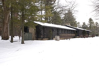
The White Pines State Park Lodge and Cabins are located in rural Ogle County, Illinois near the village of Mount Morris. They were added to the National Register of Historic Places in 1985. The Cabins are one of two Historic Places found in or near Mount Morris, the other is the Samuel M. Hitt House. The Lodge and Cabins are part of a National Register Multiple Property Submission, they were submitted with several other state park lodges, all designed by Joseph F. Booton.

<span class="mw-page-title-main">Lake Keomah State Park</span> State park in Mahaska County, Iowa

Lake Keomah State Park is a state park of Iowa, USA. It is in Mahaska County. To the park's immediate east is Keomah Village and the park is approximately 4 miles (6.4 km) east of Oskaloosa.

<span class="mw-page-title-main">Backbone State Park</span> State park in Iowa

Backbone State Park is Iowa's oldest state park, dedicated in 1919. Located in the valley of the Maquoketa River, it is approximately three miles (5 km) south of Strawberry Point in Delaware County. It is named for a narrow and steep ridge of bedrock carved by a loop of the Maquoketa River originally known as the Devil's Backbone. The initial 1,200 acres (490 ha) were donated by E.M. Carr of Lamont, Iowa. Backbone Lake Dam, a relatively low dam built by the Civilian Conservation Corps (CCC) in the 1930s, created Backbone Lake. The CCC constructed a majority of trails and buildings which make up the park.

<span class="mw-page-title-main">Copper Falls State Park</span> State park in Ashland County, Wisconsin

Copper Falls State Park is a 3,068-acre (1,242 ha) state park in Wisconsin. The park contains a section of the Bad River and its tributary the Tylers Forks, which flow through a gorge and drop over several waterfalls. Old Copper Culture Indians and later European settlers mined copper in the area. The state park was created in 1929 and amenities were developed by the Civilian Conservation Corps and the Works Progress Administration. In 2005 the park was listed on the National Register of Historic Places as a site with 10 contributing properties.

<span class="mw-page-title-main">Old Faithful Historic District</span> Historic district in Wyoming, United States

The Old Faithful Historic District in Yellowstone National Park comprises the built-up portion of the Upper Geyser Basin surrounding the Old Faithful Inn and Old Faithful Geyser. It includes the Old Faithful Inn, designed by Robert Reamer and is itself a National Historic Landmark, the upper and lower Hamilton's Stores, the Old Faithful Lodge, designed by Gilbert Stanley Underwood, the Old Faithful Snow Lodge, and a variety of supporting buildings. The Old Faithful Historic District itself lies on the 140-mile Grand Loop Road Historic District.

<span class="mw-page-title-main">Death Canyon Barn</span> United States historic place

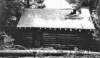
The Death Canyon Barn is a combination barn and ranger patrol cabin in Grand Teton National Park. The barn was built in Death Canyon on the Death Canyon Trail at its junction with the Alaska Basin Trail by the Civilian Conservation Corps in 1935 in the National Park Service rustic style. Located with a clear view of Prospector Mountain, it shares a common style and purpose with the Cascade Canyon Barn to the north in the park, with minor differences attributable to available materials and the preferences of the work crews building the barns.

Roaring River State Park is a public recreation area covering of 4,294 acres (1,738 ha) eight miles (13 km) south of Cassville in Barry County, Missouri. The state park offers trout fishing on the Roaring River, hiking on seven different trails, and the seasonally open Ozark Chinquapin Nature Center.

<span class="mw-page-title-main">Centennial Work Center</span> United States historic place

The Centennial Work Center in Medicine Bow National Forest near Centennial, Wyoming was built in 1938. It was built to replace the nearby Centennial Ranger Station. It was designed by USDA Forest Service, Region 2 in USFS rustic architecture and served as a government office. It was listed on the National Register of Historic Places for its architecture. The listing included three contributing buildings, a bunkhouse, a combined office and bunkhouse, and a garage, on 5 acres (2.0 ha).

<span class="mw-page-title-main">Bryce Canyon Lodge Historic District</span> Historic district in Utah, United States

The Bryce Canyon Lodge Historic District surrounds and includes the Bryce Canyon Lodge in Bryce Canyon National Park, as well as the survivors of a large complex of buildings that comprised the core of the park's visitor services area in the 1930s.

<span class="mw-page-title-main">Shady Lake Recreation Area</span> United States historic place

Shady Lake Recreation Area is a campground and public recreation area in southwestern Ouachita National Forest, southwest of Mena, Arkansas and west of Glenwood, Arkansas. The area is oriented around Shady Lake, a body of water on the South Fork Saline River impounded by a dam built c. 1940 by the Civilian Conservation Corps (CCC). The area is administered by the United States Forest Service (USFS).

<span class="mw-page-title-main">Lacey-Keosauqua State Park</span> State park in Iowa

Lacey-Keosauqua State Park is located southwest of Keosauqua, Iowa, United States. The park is located along the Des Moines River in Van Buren County. First dedicated in 1921, it is the largest state park in size in Iowa. In 1990, three areas were named nationally recognized historic districts and listed on the National Register of Historic Places.

Civilian Conservation Corp Camp F-10, also called the Rockerville Civilian Conservation Corp Camp, is a historic district on Silver Mountain Road, 15 miles (24 km) southwest of Rapid City, South Dakota. Between 1933 and 1935, it functioned as a base camp for Civilian Conservation Corps (CCC) workers who were employed on multiple construction and forestry projects in the area during the Great Depression. The camp was added to the National Register of Historic Places in 2004; three buildings and the remains of a fireplace are included in the listing.

References

  1. 1 2 "Black Moshannon State Park: History". Pennsylvania Department of Conservation and Natural Resources. Archived from the original on June 9, 2011. Retrieved March 30, 2008.
  2. 1 2 "Pennsylvania State Parks: The CCC Years". Pennsylvania Department of Conservation and Natural Resources. Archived from the original on February 5, 2004. Retrieved March 30, 2008.
  3. 1 2 3 4 "Black Moshannon State Park, Family Cabin District" (PDF). Pennsylvania's Historic Architecture and Archaeology. Retrieved September 15, 2010.
  4. "History Company 359, S-71-Pa., Philipsburg, Pa" (PDF). Civilian Conservation Corps. 1936. Archived from the original (PDF) on February 25, 2009. Retrieved March 31, 2008.
  5. 1 2 3 4 5 "Black Moshannon State Park, Beach and Day Use District" (PDF). Pennsylvania's Historic Architecture and Archaeology. Retrieved September 15, 2010.
  6. "National Register of Historic Places - Pennsylvania (PA) - Centre County - Historic Districts" . Retrieved March 30, 2008.
  7. 1 2 "Black Moshannon State Park, Maintenance District" (PDF). Pennsylvania's Historic Architecture and Archaeology. Retrieved September 15, 2010.