
The Ogallala Aquifer is a shallow water table aquifer surrounded by sand, silt, clay, and gravel located beneath the Great Plains in the United States. As one of the world's largest aquifers, it underlies an area of approximately 174,000 sq mi (450,000 km2) in portions of eight states. It was named in 1898 by geologist N. H. Darton from its type locality near the town of Ogallala, Nebraska. The aquifer is part of the High Plains Aquifer System, and resides in the Ogallala Formation, which is the principal geologic unit underlying 80% of the High Plains.
Carolina bays are elliptical to circular depressions concentrated along the East Coast of the United States within coastal New York, New Jersey, Delaware, Maryland, Virginia, North Carolina, South Carolina, Georgia, and north Florida. In Maryland, they are called Maryland basins. Within the Delmarva Peninsula, they and other coastal ponds are also called Delmarva bays.
The Kansan glaciation or Kansan glacial was a glacial stage and part of an early conceptual climatic and chronological framework composed of four glacial and interglacial stages.
The Illinoian Stage is the name used by Quaternary geologists in North America to designate the period c.191,000 to c.130,000 years ago, during the Chibanian stage of the Pleistocene, when sediments comprising the Illinoian Glacial Lobe were deposited. It precedes the Sangamonian Stage and follows the Pre-Illinoian Stage in North America. The Illinoian Stage is defined as the period of geologic time during which the glacial tills and outwash, which comprise the bulk of the Glasford Formation, accumulated to create the Illinoian Glacial Lobe. It occurs at about the same time as the penultimate glacial period.
The Yarmouthian stage and the Yarmouth Interglacial were part of a now obsolete geologic timescale of the early Quaternary of North America.
Texas contains a wide variety of geologic settings. The state's stratigraphy has been largely influenced by marine transgressive-regressive cycles during the Phanerozoic, with a lesser but still significant contribution from late Cenozoic tectonic activity, as well as the remnants of a Paleozoic mountain range.

The San Juan Basin is a geologic structural basin located near the Four Corners region of the Southwestern United States. The basin covers 7,500 square miles and resides in northwestern New Mexico, southwestern Colorado, and parts of Utah and Arizona. Specifically, the basin occupies space in the San Juan, Rio Arriba, Sandoval, and McKinley counties in New Mexico, and La Plata and Archuleta counties in Colorado. The basin extends roughly 100 miles (160 km) N-S and 90 miles (140 km) E-W.

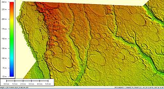
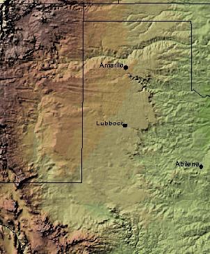
Blackwater Draw is an intermittent stream channel about 140 km (87 mi) long, with headwaters in Roosevelt County, New Mexico, about 18 km (11 mi) southwest of Clovis, New Mexico, and flows southeastward across the Llano Estacado toward the city of Lubbock, Texas, where it joins Yellow House Draw to form Yellow House Canyon at the head of the North Fork Double Mountain Fork Brazos River. It stretches across eastern Roosevelt County, New Mexico, and Bailey, Lamb, Hale, and Lubbock Counties of West Texas and drains an area of 1,560 sq mi (4,040 km2).
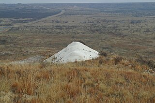
Mount Blanco is a small white hill — an erosional remnant — located on the eastern border of the Llano Estacado within Blanco Canyon in Crosby County, Texas. With Blanco Canyon, it is the type locality of the early Pleistocene Blanco Formation of Texas and Kansas, as well as the Blancan fauna, which occurs throughout North America. Mount Blanco is a Late Blancan age site, and is associated with other Late Blancan sites from Texas such as Red Light and Hudspeth local faunas from Hudspeth County, and the Cita Canyon fauna from Randall County.

The Niobrara Formation, also called the Niobrara Chalk, is a geologic formation in North America that was deposited between 87 and 82 million years ago during the Coniacian, Santonian, and Campanian stages of the Late Cretaceous. It is composed of two structural units, the Smoky Hill Chalk Member overlying the Fort Hays Limestone Member. The chalk formed from the accumulation of coccoliths from microorganisms living in what was once the Western Interior Seaway, an inland sea that divided the continent of North America during much of the Cretaceous. It underlies much of the Great Plains of the US and Canada. Evidence of vertebrate life is common throughout the formation and includes specimens of plesiosaurs, mosasaurs, pterosaurs, and several primitive aquatic birds. The type locality for the Niobrara Chalk is the Niobrara River in Knox County in northeastern Nebraska. The formation gives its name to the Niobrara cycle of the Western Interior Seaway.
Vance T. Holliday is a professor in the School of Anthropology and the department of Geosciences as well as an adjunct professor in the department of Geography at the University of Arizona in Tucson.

The Pliocene to Late Neogene Bidahochi Formation lies at an elevation of about 6,300 feet (1,920 m) to 6,600 feet (2,012 m) at the southeast of the Colorado Plateau; the deposits are from Hopi Lake, and the deposits extend southwards to the region at the north perimeter of the White Mountains of central-east Arizona. Bidahochi Lake is thought to have been a single "large lake, or several shallow, and ephemeral ones." Various fossil types are found; also bird trackways.

The Ogallala Formation is a Miocene to early Pliocene geologic formation in the central High Plains of the western United States and the location of the Ogallala Aquifer. In Nebraska and South Dakota it is also classified as the Ogallala Group. Notably, it records the North American Land Mammal Ages (NALMAs) Hemphillian, Clarendonian, and Barstovian. It also includes an excellent record of grass seeds and other plant seeds, which can be used for biostratigraphic dating within the formation. The Ogallala Formation outcrops of Lake Meredith National Recreation Area preserve fish fossils. Similar specimens from the same unit are found at Alibates Flint Quarries National Monument in Texas.
Ochotona spanglei is an extinct species of pika, known from Late Miocene - Early Pliocene fossil from Oregon (USA). Fossils were also found in Nebraska referred to as Ochotona cf. spanglei.
The Valentine Formation is a geologic unit formation or member within the Ogallala unit in northcentral Nebraska near the South Dakota border. It preserves fossils dating to the Neogene period and is particularly noted for Canid fossils. A particular feature of the Valentine is lenticular beds of green-gray opaline sandstone that can be identified in other states, including South Dakota, Nebraska, Kansas, and Colorado. Even though three mammalian fauna stages can be mapped throughout the range of the Ogallala, no beddings of the Ogallala are mappable and all attempts of formally applying the Valentine to any mappable lithology beyond the type location have been abandoned. Even so, opaline sandstone has been used to refer to the green-gray opalized conglomerate sandstone that is a particular feature of the lower Ogallala.

The Blanco Formation, originally named the Blanco Canyon Beds, is an early Pleistocene geologic formation of clay, sand, and gravel whitened by calcium carbonate cementation and is recognized in Texas and Kansas.
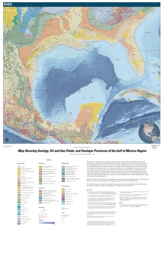
The formation of the Gulf of Mexico, an oceanic rift basin located between North America and the Yucatan Block, was preceded by the breakup of the Supercontinent Pangaea in the Late-Triassic, weakening the lithosphere. Rifting between the North and South American plates continued in the Early-Jurassic, approximately 160 million years ago, and formation of the Gulf of Mexico, including subsidence due to crustal thinning, was complete by 140 Ma. Stratigraphy of the basin, which can be split into several regions, includes sediments deposited from the Jurassic through the Holocene, currently totaling a thickness between 15 and 20 kilometers.

The geology of Slovakia is structurally complex, with a highly varied array of mountain ranges and belts largely formed during the Paleozoic, Mesozoic and Cenozoic eras.
The geology of Denmark includes 12 kilometers of unmetamorphosed sediments lying atop the Precambrian Fennoscandian Shield, the Norwegian-Scottish Caledonides and buried North German-Polish Caledonides. The stable Fennoscandian Shield formed from 1.45 billion years ago to 850 million years ago in the Proterozoic. The Fennoscandian Border Zone is a large fault, bounding the deep basement rock of the Danish Basin—a trough between the Border Zone and the Ringkobing-Fyn High. The Sorgenfrei-Tornquist Zone is a fault-bounded area displaying Cretaceous-Cenozoic inversion.
The Tahoka Formation is a geological formation in Texas and New Mexico, which was emplaced in now-dry lakes during late Pleistocene wet periods.

