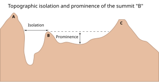
In topography, prominence measures the height of a mountain or hill's summit relative to the lowest contour line encircling it but containing no higher summit within it. It is a measure of the independence of a summit. A peak's key col is a unique point on this contour line and the parent peak is some higher mountain, selected according to various criteria.

Stob Coire Easain is a Scottish Munro mountain which reaches a height of 1115 metres (3658 feet), situated 18 kilometres east of Fort William. It stands on the western side of Loch Treig, along with its "twin", the Munro Stob a' Choire Mheadhoin. Collectively the pair are called "The Easains" or the "Stob Corries" and stand just one kilometre apart connected by a high col with an approximate height of 965 metres. The fine corrie of Coire Easain Beag lies in between the two mountains facing north west. Stob Coire Easain’s name translates from the Gaelic as “Peak of the Corrie of the Little Waterfall”. This mountain should not be confused with another Stob Coire Easain, a Munro “Top” on the Munro Stob Coire an Laoigh

The topographic isolation of a summit is the minimum distance to a point of equal elevation, representing a radius of dominance in which the peak is the highest point. It can be calculated for small hills and islands as well as for major mountain peaks and can even be calculated for submarine summits.

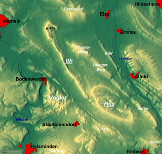
The Ith is a ridge in Germany's Central Uplands which is up to 439 m high. It lies about 40 km southwest of Hanover and, at 22 kilometres, is the longest line of crags in North Germany.

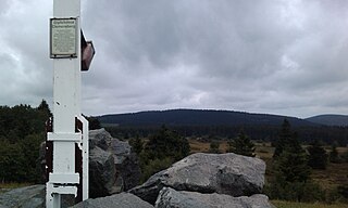
The Langenberg rises on the state border between North Rhine-Westphalia and Hesse in Germany and, at 843.2 m above sea level (NN), is the highest peak in the Rothaar mountain range, as well as the highest point in the North Rhine-Westphalia and also in the north of Germany outside the Harz Mountains.

The Hils is a range of hills in Germany's Central Uplands that is up to 480.4 m high. It is located in the districts of Holzminden, Hildesheim and Northeim, in the state of Lower Saxony.

The Leine Uplands is a region in Germany's Central Uplands which forms a part of the Lower Saxon Hills and lies along the River Leine between Göttingen and Hanover. It borders on the Weser Uplands in the west, the Innerste Uplands in the northeast, the Harz in the east and Untereichsfeld in the southeast.

The Köterberg, at 495.8 m (1,627 ft) above sea level, is the highest hill in the Lippe Uplands and lies on the state border between North Rhine-Westphalia and Lower Saxony in North Germany. On its northern slopes is the village of Köterberg.

The Hohe Egge, at a good 440 m above NN, is the highest point on the Süntel ridge in the Calenberg Uplands in the German federal state of Lower Saxony. On its summit is the Süntel Tower.
The Reuberg is a ridge, up to 328.2 m above NN, in the Lower Saxon Hills in the districts of Holzminden and Hildesheim in the German state of Lower Saxony.

The Ellerspring, at 657.5 m above sea level (NHN), is the highest point of the Soonwald, a part of the Hunsrück mountains in the German Central Uplands. It is situated near Winterbach in the county of Bad Kreuznach in the state of Rhineland-Palatinate

The Plackweghöhe, whose main summit has hitherto had no official name, is the highest point in the borough of Warstein, the hill ridge of the Plackwald, the North Sauerland Uplands, and the Arnsberg Forest Nature Park in the German state of North Rhine-Westphalia. It is 581.5 m above sea level (NHN) and lies within the counties of Soest and Hochsauerlandkreis. The Lörmecke Tower observation tower at the top is a popular destination.

At 869 m above sea level (NN), the Großer Farmdenkopf is the highest peak in the Thuringian Highland. It is situated in the county of Sonneberg in the German state of Thuringia.

The Blackjack Mountains are a mountain range located in Gila County, Arizona. They have a maximum elevation of 6,942 ft (2,116 m) at Apache Peaks and a prominence of 2,580 ft (790 m). The peak has a topographic isolation of 17.88 miles, with the nearest higher peak lying to the south in the Pinal Mountains. The Blackjack mountains are located within the Tonto National Forest and are north of Globe, Arizona. The high point of the range, Apache Peaks, is ranked 36th in prominence for Arizona's most prominent peaks.
The Heydaer Berg between Plaue and Ilmenau in the Thuringian county of Ilm-Kreis is a hill ridge of the Reinsberge which reaches its highest point at the Halskappe which is 605.4 m above sea level (NHN),, shortly before the better known Reinsburg (604.1 m).


