
The Department of Conservation and Recreation (DCR) is a state agency of the Commonwealth of Massachusetts, United States, situated in the Executive Office of Energy and Environmental Affairs. It is best known for its parks and parkways. The DCR's mission is "To protect, promote and enhance our common wealth of natural, cultural and recreational resources for the well-being of all." The agency is the largest landowner in Massachusetts.

Blue Hills Reservation is a 7,000-acre (2,800 ha) state park in Norfolk County, Massachusetts in the United States. Managed by the Massachusetts Department of Conservation and Recreation, it covers parts of Milton, Quincy, Braintree, Canton, Randolph, and Dedham. Located approximately ten miles south of downtown Boston, the reservation is one of the largest parcels of undeveloped conservation land within the Greater Boston metropolitan area. The park's varied terrain and scenic views make it a popular destination for hikers from the Boston area.

The Neponset Valley Parkway is a historic parkway in southern Boston and Milton, Massachusetts, United States. It is a connecting parkway in the Greater Boston area's network, providing a connection between the Blue Hills Reservation, Neponset River Reservation, and the Stony Brook Reservation. The parkway was constructed between 1898 and 1929 with design assistance from Charles Eliot and the Olmsted Brothers. It was listed on the National Register of Historic Places in 2005.

The Truman Parkway is a historic parkway in Milton and southern Boston, Massachusetts. It runs along the southern boundary of a portion of the Neponset River Reservation and serves as a connection between the Neponset Valley Parkway and the Blue Hills Parkway. The parkway was built in 1931 and added to the National Register of Historic Places in 2005.

The Veterans of Foreign Wars Parkway is a historic parkway in Boston, Massachusetts. The southern terminus of the parkway is at Washington Street at the Dedham-West Roxbury border, from where it travels north and then east, ending at a junction with Centre Street, near the Arnold Arboretum. The highway is almost entirely contained within the West Roxbury neighborhood, although it passes through part of the Chestnut Hill neighborhood near its junction with the West Roxbury Parkway. Most of its length, from Spring Street in West Roxbury to its eastern end, is administered by the Massachusetts Department of Conservation and Recreation (DCR), a successor to the Metropolitan District Commission (MDC) which oversaw the road's construction. The parkway was built in stages between 1930 and 1942, and was designed to provide a parkway connection from the Upper Charles River Reservation to other MDC parks via the West Roxbury Parkway. The DCR portion of the road was listed on the National Register of Historic Places in 2005. The road formerly carried the designation for U.S. Route 1.

Winthrop Shore Drive is a historic parkway in Winthrop, Massachusetts. The mile-long parkway runs through the Winthrop Beach Reservation, and is administered by the Massachusetts Department of Conservation and Recreation (DCR). The parkway is one of a series of ocean parkways that make up a network of parkways connecting major open spaces in the Greater Boston area. Both the parkway and reservation were designed in the mid-1890s by Charles Eliot for the Metropolitan Parks Commission, a predecessor to the DCR. Land was acquired for the parkway in 1899, and construction was largely completed in 1900.
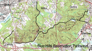
The Blue Hills Reservation Parkways are a network of historic parkways in and around the Blue Hills Reservation, a Massachusetts state park south of Boston, Massachusetts. It consists of six roadways that provide circulation within the park, and that join the park to two connecting parkways, the Blue Hills Parkway and the Furnace Brook Parkway. The roadway network was designed by Charles Eliot in the 1890s, except for Green Street, which was added to the network in the 1940s. The parkways were added to the National Register of Historic Places in 2003.
Fellsmere Park is a historic park that was designed by the famous landscape architect Frederick Law Olmsted for the city. The construction began in 1893 and was finished in 1899. Most of the land for the park was donated by Malden's first mayor Elisha S. Converse. After the fire on his rubber shoe factory in 1875, he purchased the swamp planning to turn it into a water reservoir in case of emergency. Later, following the advice of the noted journalist Sylvester Baxter, he donated the land for establishing a beautiful public park with a pond. In 1905 the city turned the park over to the Metropolitan Parks Commission. The MPC in 1913 designed the boundary roads of the park, which were listed on the National Register of Historic Places in May 2003 as Fellsmere Park Parkways. Fellsway East, which is part of the Fellsway Connector Parkways, runs through Fellsmere Park on the east side of Fellsmere Pond.

The Fells Connector Parkways are a group of historic parkways in the cities of Malden and Medford, Massachusetts, suburbs north of the city of Boston. The three parkways, The Fellsway, Fellsway West, and Fellsway East serve to provide access from the lower portion of the Mystic River Reservation to the Middlesex Fells Reservation. The latter two parkways continue northward, providing access to the interior of the Fells and providing a further connection to Lynn Fells Parkway. Significant portions of these parkways south of the Fells, which were among the first connecting parkways designed to be part of the Metropolitan Park System of Greater Boston by Charles Eliot, were listed on the National Register of Historic Places in 2003.

The Charles River Reservation Parkways are parkways that run along either side of the Charles River in eastern Massachusetts. The roads are contained within the Charles River Reservation and the Upper Charles River Reservation, and fall within a number of communities in the greater Boston metropolitan area. The Charles River parks extend from the Charles River Dam, where the Charles empties into Boston Harbor, to Riverdale Park in the West Roxbury neighborhood of Boston. Most of the roadways within the parks are listed on the National Register of Historic Places as a unit, although Storrow Drive and Memorial Drive are listed as part of the Charles River Basin Historic District.

The Middlesex Fells Reservoirs Historic District is a historic district roughly bounded by Pond St., Woodland Rd., I-93, and MA 28 in Stoneham and Medford, Massachusetts. It encompasses a portion of the Middlesex Fells Reservation, a state park managed by the Massachusetts Department of Conservation and Recreation (DCR). The principal features of the district are three reservoirs and their associated gate houses and pumping stations, which were developed by the Metropolitan District Commission starting in the late 19th century. The district was listed on the National Register of Historic Places in 1990.
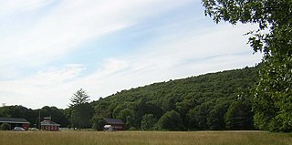
Brookwood Farm is a historic farm on Blue Hill River Road in Canton, Massachusetts. Some of its fields, but none of the buildings, are in Milton. It is owned by the Commonwealth of Massachusetts and managed by the Department of Conservation and Recreation.

The Comfort Station is a historic "sanitary" on Canton Avenue in Milton, Massachusetts. It is located in the Blue Hills Reservation, managed by the Massachusetts Department of Conservation and Recreation (DCR). Built in 1904, it is one of a suite of buildings designed by Stickney & Austin for the Massachusetts Parks Commission, a predecessor organization to the DCR, as the reservation was being developed for more active recreational pursuits. It was added to the National Register of Historic Places on September 25, 1980.

The Metropolitan District Commission Stable is a historic stable on Hillside Street in Milton, Massachusetts. Built around the turn of the 20th century, it is part of a headquarters complex designed by Stickney & Austin for the Metropolitan Parks Commission when the Blue Hills Reservation was being developed for recreational use. The building is a good example of Shingle style architecture, and was listed on the National Register of Historic Places in 1980.

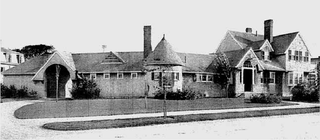
The Refreshment Pavilion is a historic refreshment stand at Houghton's Pond in the Milton portion of Blue Hills Reservation, a Massachusetts state park. Built in 1920, it is one of a series of architect-designed structures built in the park by the Metropolitan District Commission. It was listed on the National Register of Historic Places in 1980.

The Metropolitan Park System of Greater Boston is a system of reservations, parks, parkways and roads under the control of the Massachusetts Department of Conservation and Recreation (DCR) in and around Boston that has been in existence for over a century. The title is used by the DCR to describe the areas collectively: "As a whole, the Metropolitan Park System is currently eligible for listing on the National Register of Historic Places", as outlined on the department's website. The DCR maintains a separate Urban Parks and Recreation division to oversee the system, one of five such divisions within the department—DCR's Bureau of State Parks and Recreation manages the remainder of Massachusetts state parks. Direct design and maintenance functions for the parkways and roads within the system are provided by the DCR Bureau of Engineering.

Stony Brook Reservation is a woodland park in Boston and Dedham, Massachusetts, a unit of the Metropolitan Park System of Greater Boston, part of the state park system of Massachusetts. It was established in 1894 as one of the five original reservations created by the Metropolitan Park Commission. The park is served by the Stony Brook Reservation Parkways, a road system that was entered into the National Register of Historic Places in 2006.
The Charles River Reservation (Speedway)-Upper Basin Headquarters is located at the corner of Western Avenue and Soldiers Field Road in the Brighton neighborhood of Boston, Massachusetts. It is a complex of seven buildings designed by architect William D. Austin in the Shingle and Colonial Revival styles and built between 1899 and 1940. The site served as the headquarters of the State-managed Charles River Reservation and as horse stables for the Charles River Speedway, a harness and bicycle racing track along present-day Soldiers Field Road. The Massachusetts Department of Conservation and Recreation (DCR) owns the Speedway Headquarters and considers it to be one of its origin properties.
William Downes Austin was an architect and author in the United States. He was a partner with Frederick W. Stickney at Stickney & Austin from 1892 until 1900. Austin worked out of their Boston office while Stickney worked out of the Lowell office. After the partnership ended in 1900, they both maintained each other's names in their respective practices. One of their first projects was the Highland Club in Lowell.


