Boos, Mayen-Koblenz

Last updated
Boos
Wappen der Ortsgemeinde Boos.png
Coat of arms
Germany adm location map.svg
Red pog.svg
Boos
Location of Boos within Mayen-Koblenz district
Boos in MYK.PNG
Coordinates: 50°18′47″N7°1′10″E / 50.31306°N 7.01944°E / 50.31306; 7.01944 Coordinates: 50°18′47″N7°1′10″E / 50.31306°N 7.01944°E / 50.31306; 7.01944
Country Germany
State Rhineland-Palatinate
District Mayen-Koblenz
Municipal assoc. Vordereifel
Government
   Mayor Friedhelm Stephani
Area
  Total 10.38 km2 (4.01 sq mi)
Elevation 470 m (1,540 ft)
Population (2015-12-31) [1]
  Total 608
  Density 59/km2 (150/sq mi)
Time zone CET/CEST (UTC+1/+2)
Postal codes 56729
Dialling codes 02656
Vehicle registration MYK
Website www.boos-eifel.de

Boos is a municipality in the county of Mayen-Koblenz in Rhineland-Palatinate, western Germany.

Mayen-Koblenz District in Rhineland-Palatinate, Germany

Mayen-Koblenz is a district (Kreis) in the north of Rhineland-Palatinate, Germany. Neighboring districts are Ahrweiler, Neuwied, Westerwaldkreis, district-free Koblenz, Rhein-Lahn, Rhein-Hunsrück, Cochem-Zell, and Vulkaneifel.

Rhineland-Palatinate State in Germany

Rhineland-Palatinate is a state of Germany.

Germany Federal parliamentary republic in central-western Europe

Germany, officially the Federal Republic of Germany, is a country in Central and Western Europe, lying between the Baltic and North Seas to the north, and the Alps to the south. It borders Denmark to the north, Poland and the Czech Republic to the east, Austria and Switzerland to the south, France to the southwest, and Luxembourg, Belgium and the Netherlands to the west.

Geography

The parish lies in the East Eifel, a mountain region characterised by volcanic maars and covers an area of 10.38 km², of which 5.02 km² are forest. In 2000, a nature reserve was established, the Booser Maar, with an area of 1.52 km².

Eifel low mountain range in Germany

The Eifel is a low mountain range in western Germany and eastern Belgium. It occupies parts of southwestern North Rhine-Westphalia, northwestern Rhineland-Palatinate and the south of the German-speaking Community of Belgium.

Maar Low-relief volcanic crater

A maar is a broad, low-relief volcanic crater caused by a phreatomagmatic eruption. A maar characteristically fills with water to form a relatively shallow crater lake which may also be called a maar. The name comes from a Moselle Franconian dialect word used for the circular lakes of the Daun area of Germany. Maars are shallow, flat-floored craters that scientists interpret as having formed above diatremes as a result of a violent expansion of magmatic gas or steam; deep erosion of a maar presumably would expose a diatreme. Maars range in size from 60 to 8,000 m across and from 10 to 200 m deep; most maars commonly fill with water to form natural lakes. Most maars have low rims composed of a mixture of loose fragments of volcanic rocks and rocks torn from the walls of the diatreme.

Nature reserve protected area for flora, fauna or features of geological interest

A nature reserve is a protected area of importance for flora, fauna or features of geological or other special interest, which is reserved and managed for conservation and to provide special opportunities for study or research. Nature reserves may be designated by government institutions in some countries, or by private landowners, such as charities and research institutions, regardless of nationality. Nature reserves fall into different IUCN categories depending on the level of protection afforded by local laws. Normally it is more strictly protected than a nature park.

Boos is the westernmost municipality of the county of Mayen-Koblenz and lies in the Volcanic Eifel, around five kilometres southeast of the Nürburgring racetrack. Northwest of the village is the Eifel Tower, erected in 2003, on the 557-metre-high hill of Schneeberg with views over the local area including the Booser Doppelmaar, a double maar.

Volcanic Eifel region in the Eifel Mountains in Germany, that is defined to a large extent by its volcanic geological history

The Volcanic Eifel or Vulkan Eifel is a region in the Eifel Mountains in Germany, that is defined to a large extent by its volcanic geological history. Characteristic of this volcanic field are its typical explosion crater lakes or maars, and numerous other signs of volcanic activity such as volcanic tuffs, lava streams and volcanic craters like the Laacher See. The Volcanic Eifel is still volcanically active today. One sign of this activity is the escaping gases, for example, in the Laacher See.

Nürburgring race track in Nürburg, Rhineland-Palatinate, Germany

The Nürburgring is a 150,000 person capacity motorsports complex located in the town of Nürburg, Rhineland-Palatinate, Germany. It features a Grand Prix race track built in 1984, and a much longer Nordschleife "North loop" track which was built in the 1920s around the village and medieval castle of Nürburg in the Eifel mountains. The north loop is 20.8 km (12.9 mi) long and has more than 300 metres of elevation change from its lowest to highest points. Jackie Stewart nicknamed the old track "The Green Hell".

Booser Doppelmaar

The Booser Doppelmaar comprises two maars that have silted up and, today, form shallow depressions in the countryside. They lie on the territory of the village of Boos, a few hundred metres west of the village itself. The two maars were formed 10,150 to 14,160 years ago and belong to the Quaternary volcano field of the Volcanic Eifel. From a natural region perspective it lies in the south of the Hohe Acht Upland, ca. 7.8 km south of the summit of the Hohe Acht.

Related Research Articles

Vulkaneifel District in Rhineland-Palatinate, Germany

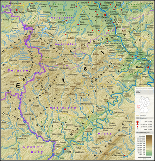
Vulkaneifel is a district (Kreis) in the northwest of the state Rhineland-Palatinate, Germany. It is the least densely populated district in the state and the fourth most sparsely populated district in Germany. The administrative centre of the district is in Daun. Neighboring districts are Euskirchen, Ahrweiler, Mayen-Koblenz, Cochem-Zell, Bernkastel-Wittlich, and Bitburg-Prüm.

Daun, Germany Place in Rhineland-Palatinate, Germany

Daun is a town in the Vulkaneifel district in Rhineland-Palatinate, Germany. It is the district seat and also the seat of the Verbandsgemeinde of Daun.

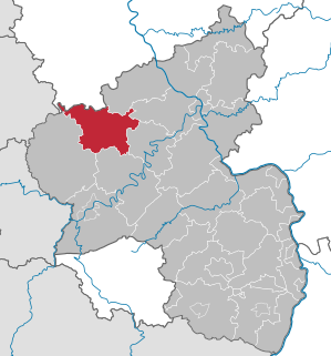
Vordereifel is a Verbandsgemeinde in the district of Mayen-Koblenz, in Rhineland-Palatinate, Germany. It is situated on the eastern edge of the Eifel, west of Mayen. The seat of the municipality is in Mayen, itself not part of the municipality.

Acht (Eifel) Place in Rhineland-Palatinate, Germany

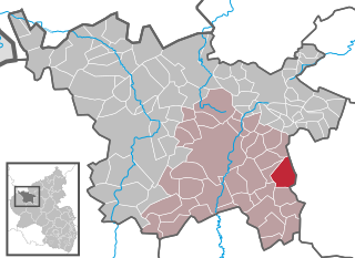
Acht is a municipality in the district of Mayen-Koblenz in Rhineland-Palatinate, western Germany. It is situated on the eastern edge of the Eifel.

Ochtendung Place in Rhineland-Palatinate, Germany

Ochtendung is a municipality in the district of Mayen-Koblenz in Rhineland-Palatinate, western Germany.

Demerath Place in Rhineland-Palatinate, Germany

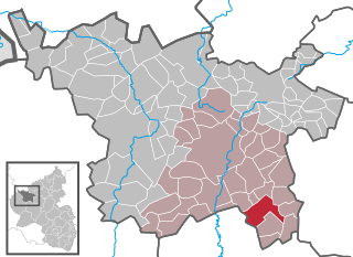
Demerath is an Ortsgemeinde – a municipality belonging to a Verbandsgemeinde, a kind of collective municipality – in the Vulkaneifel district in Rhineland-Palatinate, Germany. It belongs to the Verbandsgemeinde of Daun, whose seat is in the like-named town.

Duppach Place in Rhineland-Palatinate, Germany

Duppach is an Ortsgemeinde, part of a group of municipalities called the Verbandsgemeinde of Gerolstein, which is located in the town of Gerolstein in the Vulkaneifel district of the state of Rhineland-Palatinate, Germany.

Gillenfeld Place in Rhineland-Palatinate, Germany

Gillenfeld is an Ortsgemeinde – a municipality belonging to a Verbandsgemeinde, a kind of collective municipality – in the Vulkaneifel district in Rhineland-Palatinate, Germany. It belongs to the Verbandsgemeinde of Daun, whose seat is in the like-named town.

Nitz Place in Rhineland-Palatinate, Germany

Nitz is an Ortsgemeinde – a municipality belonging to a Verbandsgemeinde, a kind of collective municipality – in the Vulkaneifel district in Rhineland-Palatinate, Germany. It belongs to the Verbandsgemeinde of Kelberg, whose seat is in the like-named municipality.

Volcano Park, Mayen-Koblenz

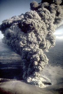
The Volcano Park in Mayen-Koblenz is a geopark in the rural district of Mayen-Koblenz in the eastern Vulkan Eifel, Germany. It was founded in 1996 and wraps around the Laacher See. Together with the Volcano Park, Brohltal/Laacher See and the Vulkan Eifel Nature and Geo-Park, it forms part of the national Eifel Volcano Land Geo-Park. The three parks are connected by the 280-kilometre-long German Volcano Route.

Volcanic Eifel Nature Park nature park in Rhineland-Palatinate, Germany

The Volcanic Eifel Nature Park lies in the counties of Bernkastel-Wittlich, Cochem-Zell and Vulkaneifel in the German state of Rhineland-Palatinate. The nature park, which is in the Eifel mountains, and which is also a geopark, was inaugurated on 31 May 2010 and has an area of 1,068.24 km².> Its sponsor is the Natur- und Geopark Vulkaneifel GmbH.

German Volcano Route 280 km touristic route from the river Rhine to the upper Eifel-mountains region along vocanic features of the Eifel.

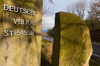
The German Volcano Route or, less commonly, German Volcano Road is a 280-kilometre-long tourist route from the River Rhine to the mountains of the High Eifel. It links 39 sites within the Geopark Vulkanland Eifel in the Volcanic Eifel (Vulkaneifel), at which geological, cultural-historical and industrial-historical nature and cultural monuments on the subject of volcanicity in the Eifel are located.

Hochsimmer mountain

The Hochsimmer is a volcanic cone, 587.9 m above sea level (NHN), in the Eifel Mountains in Germany. It rises near Ettringen in the Rhineland-Palatine county of Mayen-Koblenz. At the summit is an observation tower, the Hochsimmer Tower.

Hochstein (Eifel) mountain

The Hochstein is a volcanic cone, 563 m above sea level (NHN), in the Eifel near Obermendig in the German state of Rhineland-Palatinate and county ofMayen-Koblenz.

References