
Somerville is a city located directly to the northwest of Boston, and north of Cambridge, in Middlesex County, Massachusetts, United States. As of the 2020 United States Census, the city had a total population of 81,045 people. With an area of 4.12 square miles (10.7 km2), the city has a density of 19,671/sq mi (7,595/km2), making it the most densely populated municipality in New England and the 19th most densely populated incorporated municipality in the country. Somerville was established as a town in 1842, when it was separated from Charlestown. In 2006, the city was named the best-run city in Massachusetts by The Boston Globe. In 1972, 2009, and 2015, the city received the All-America City Award. It is home to Tufts University, which has its campus along the Somerville and Medford border.
Union Square is a neighborhood in the southeastern part of Somerville, Massachusetts, United States. It is centered on Union Square proper, which is located at the intersection of Washington Street, Webster Avenue, and Somerville Avenue.
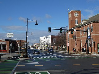
Winter Hill is a neighborhood in Somerville, Massachusetts, United States. It takes its name from the 120-foot hill that occupies its landscape, the name of which dates back to the 18th century. Winter Hill is located roughly north of Medford Street, west of McGrath Highway, and east of Magoun Square.

Spring Hill is the name of a ridge in the central part of the city of Somerville, Massachusetts, United States, and the residential neighborhood that sits atop it. It runs northwest to southeast, roughly bounded by Highland Avenue, Somerville Avenue, Elm Street, and Willow Avenue. Summer Street runs along the hill's crest.
The Bulfinch Triangle Historic District is a historic district roughly bounded by Canal, Market, Merrimac, and Causeway Streets in the West End of Boston, Massachusetts. The entire district was laid out by architect Charles Bulfinch on land reclaimed from the old Mill Pond, and is now populated by well-preserved commercial buildings from the 1870s through early 1900s. It was added to the National Register of Historic Places in 1986.

The Town Hill District is a historic district bounded roughly by Rutherford Avenue and Main and Warren Streets in the Charlestown neighborhood of Boston, Massachusetts.

The Prospect Hill Historic District encompasses a large residential area in the Willimantic section of Windham, Connecticut. Located north of the Main Street commercial district, it was developed between about 1865 and 1930, and is one of the state's largest historic districts, with more than 800 contributing buildings. It is roughly bounded by Valley, Jackson, Bolivia, Washburn, Windham, and High Streets, and contains one of the state's largest single concentrations of Victorian-era residential architecture. It was listed on the National Register of Historic Places in 2003.

The Central New Bedford Historic District is one of nine historic districts in New Bedford, Massachusetts, United States. The district encompasses the city's central business district, built up during the time in the late 19th century when textiles had replaced whaling as the city's main industry. It is a 29-acre (12 ha) rectangular area bounded by Acushnet Avenue and the older New Bedford Historic District on the east, School Street to the south, Middle Street on the north and 6th Street in the west. It was added to the National Register of Historic Places in 1980.

The Upper North Street Commercial District is a historic district on the north side of downtown Pittsfield, Massachusetts, United States. Representing an expansion of Pittsfield's historic downtown area northward from Park Square in the late 19th century, the district encompasses primarily commercial buildings fronting on North Street between Columbus and Madison Avenues on the west side, and between Eagle and Maplewood Avenues on the east side. The notable exceptions are the Berkshire Eagle building, located on Eagle Street next to Sottile Park, and the St. Joseph's Church complex. The district features Colonial Revival and Renaissance style architecture. It was added to the National Register of Historic Places in 2002.

The James H. Brooks House is a historic house in Somerville, Massachusetts. Built about 1880, it is one of the finer examples of Second Empire architecture in the city. It was listed on the National Register of Historic Places in 1989.

The Mount Vernon Street Historic District is a historic district consisting of the even-numbered houses at 8–24 Mount Vernon Street in Somerville, Massachusetts. The district includes four modest Greek Revival houses built c. 1850, an earlier Federal period house, and a late 19th century Second Empire house, representing a progression of housing styles through the 19th century. The houses at 8, 12, 16, and 20 Mount Vernon are all well conserved Greek Revival 1+1⁄2-story buildings with side hall layout, although #12 has had synthetic siding applied. The house at #16 has preserved more of its exterior detailing than the others, while #20 is distinctive for its use of flushboard siding, giving the house the appearance of ashlar masonry work. Behind the house at #12 is a second house that is some external Greek Revival styling, but has a five bay center entrance layout more typical of the Federal period; it is known to predate the house in front of it. The duplex at 22-24 Mount Vernon has a mansard roof characteristic of the Second Empire style; its construction date is estimated to be c. 1880.

The Mystic Water Works, also called the Mystic Pumping Station, is a historic water works at Alewife Brook Parkway and Capen Street in Somerville, Massachusetts. Built in 1862–65 by the city of Charlestown, it is a significant example of a mid-19th century waterworks facility. The building has been listed twice on the National Register of Historic Places. The first, in 1989, is part of the city of Somerville's listings, and was made under the name "Mystic Water Works". The second is part of an umbrella listing covering the entire historic water works system of Greater Boston, and was made in 1990, listed as the "Mystic Pumping Station".
The Spring Hill Historic District is a historic district roughly bounded by Summer, Central, Atherton, and Spring Streets in the Spring Hill area of Somerville, Massachusetts. The district encompasses the city's best-preserved residential subdivision from the mid-19th century, with later infill construction in the late 19th and early 20th centuries. The district was listed on the National Register of Historic Places in 1989.

The Riverview Terrace Historic District is a 15.2-acre (6.2 ha) historic district in Davenport, Iowa, United States, that was listed on the National Register of Historic Places in 1984. It was listed on the Davenport Register of Historic Properties in 1993. The neighborhood was originally named Burrow's Bluff and Lookout Park and contains a three-acre park on a large hill.

Union Square station is a light rail station on the Massachusetts Bay Transportation Authority (MBTA) Green Line located in the Union Square neighborhood of southeastern Somerville, Massachusetts. The accessible terminal station has a single island platform serving the two tracks of the Union Square Branch, which parallels the Fitchburg Line. It opened on March 21, 2022, as part of the Green Line Extension (GLX), which added two northern branches to the Green Line.
East Somerville is a neighborhood in the eastern part of the city of Somerville, Massachusetts, United States. The community stretches east along Broadway, from Massachusetts Route 28 to Sullivan Square and Interstate 93 on the city line with the Boston neighborhood of Charlestown.

The Head of the River Historic District is a historic district encompassing a village area at the head of navigation of the Acushnet River, which separates Acushnet and New Bedford, Massachusetts. The village is centered at the junction of Tarkin Hill Road, River Road, and Mill Road in New Bedford, and Main Street in Acushnet. The area went through two significant periods of development: the first was in the late 18th and early 19th century, and the second was in the early 20th century. The district was listed on the National Register of Historic Places in 2009.

The Canaan Street Historic District encompasses the historic original town center of Canaan, New Hampshire. It is a basically linear district, running along Canaan Street roughly from Prospect Hill Road in the north to Moss Flower Lane in the south. The town flourished first as a stagecoach stop, and then as a resort colony in the late 19th century. The historic district was listed on the National Register of Historic Places in 1973. It included 60 contributing buildings.

Gilman Square is a neighborhood in the area around Central Hill in Somerville, Massachusetts, United States. Historic Gilman Square is at the junction of Medford, Pearl, and Marshall streets and has been a small commercial center since the mid 19th-century but with the development of the Gilman Square Green Line station, city planning documents consider the area within a rough ten-minute walk of the new station to be part of the Gilman Square neighborhood.

The Moran Square Historic District is a historic district encompassing an area of late 19th and early 20th-century industrial, commercial, and residential development in Fitchburg, Massachusetts. Centered on the triangular junction of East Main Street with Lunenburg and Summer Streets, this area developed as a secondary node apart from the city's main commercial district, in an area were several industrial plants were undergoing significant growth. The district was listed on the National Register of Historic Places in 2018.


