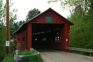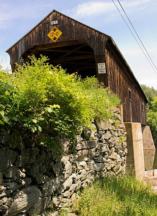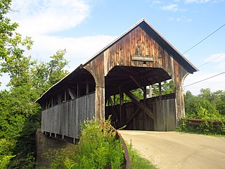
The Burt Henry Covered Bridge, also known as the Henry Covered Bridge or just the Henry Bridge, is a covered bridge that spans the Walloomsac River near Bennington, Vermont. A Town lattice truss bridge, it carries River Road, just south of the village of North Bennington. Originally built about 1840, it was listed on the National Register of Historic Places in 1973 as Bennington County's oldest covered bridge. It was rebuilt in 1989 by the Vermont Agency of Transportation.

The Columbia Bridge is a covered bridge, carrying Columbia Bridge Road over the Connecticut River between Columbia, New Hampshire and Lemington, Vermont. Built in 1911–12, it is one of only two New Hampshire bridges built with Howe trusses, and is one of the last covered bridges built in the historic era of covered bridge construction in both states. It was listed on the National Register of Historic Places in 1976.

The Mount Orne Bridge is a covered bridge over the Connecticut River between Lancaster, New Hampshire, and Lunenburg, Vermont. It joins Elm Street in South Lancaster with River Road in Lunenburg. Built in 1911, it is one of two Howe truss bridges across the Connecticut River. It was listed on the National Register of Historic Places in 1976.

The Church Street Covered Bridge, also called the Village Covered Bridge, is a wooden covered bridge that crosses the North Branch of the Lamoille River in Waterville, Vermont off State Route 109. Built in the late 19th century, it is one of five covered bridges in a space of about five miles that cross the North Branch Lamoille. It was listed on the National Register of Historic Places in 1974.

The Maple Street Covered Bridge, also called the Lower Covered Bridge and the Fairfax Covered Bridge, is a covered bridge that carries Maple Street across Mill Brook off State Route 104 in Fairfax, Vermont. Built in 1865, it is the town's only historic covered bridge, and is a rare two-lane covered bridge in the state. It was listed on the National Register of Historic Places in 1974.

The ChamberlinMill Covered Bridge, also called Chamberlin Covered Bridge or Whitcomb Covered Bridge, is a historic covered bridge that carries Chamberlain Bridge Road across the South Wheelock Branch of the Passumpsic River in Lyndon, Vermont. Built in 1881, it is one of five similar area bridges. It was listed on the National Register of Historic Places in 1974.

The Northfield Falls Covered Bridge, also called the Station Covered Bridge, is a wooden covered bridge that carries Cox Brook Road across the Dog River in Northfield, Vermont. Built in 1872, this Town lattice truss bridge is one of five surviving covered bridges in the town, and one of two that are visible from each other. It was listed on the National Register of Historic Places in 1974.

The Slaughter HouseCovered Bridge is a wooden covered bridge that carries Slaughterhouse Road across the Dog River in Northfield, Vermont. The Queen post truss bridge is one of five surviving 19th-century bridges in the town. It was listed on the National Register of Historic Places in 1974.

The Comstock Covered Bridge is a wooden covered bridge that crosses the Trout River in Montgomery, Vermont on Comstock Bridge Road. Built in 1883, it is one of several area bridges built by Sheldon & Savannah Jewett. It was listed on the National Register of Historic Places in 1974.

The Fisher Covered Railroad Bridge is a covered bridge in Wolcott, Vermont. Built in 1908, it originally carried the St. Johnsbury and Lamoille County Railroad line over the Lamoille River. Now closed, it was the last covered bridge in Vermont to carry railroad traffic, and is a rare surviving example in the state of a double Town lattice truss. It was listed on the National Register of Historic Places in 1974.

The Gorham Covered Bridge carries Gorham Bridge Road across Otter Creek in a rural area of Pittsford and Proctor, Vermont. It is a Town lattice truss bridge, built in 1841 by Abraham Owen and Nicholas M. Powers, the latter in the early stages of his career as a well-known bridgewright. The bridge was listed on the National Register of Historic Places in 1974.

The Larkin Covered Bridge is a historic covered bridge, carrying Larkin Road across the First Branch White River in northern Tunbridge, Vermont. Built in 1902, it is one of the last documented covered bridges to be built in Vermont during the historic period of bridge construction, and is one of five covered bridges in the town. It was listed on the National Register of Historic Places in 1974.

The Upper Falls Covered Bridge, also known as the Downers Covered Bridge, spans the Black River, carrying Upper Falls Road just south of Vermont Route 131 in western Weathersfield, Vermont. The Town lattice truss bridge was built in 1840 and rebuilt in 2008. Its gable ends are distinctive for their Greek Revival styling. The bridge was listed on the National Register of Historic Places in 1973.

The Willard Covered Bridge is a historic covered bridge carrying Mill Street across the Ottauquechee River in Hartland, Vermont. It is the eastern of two covered bridges on the road, which are connected via a small island in the river; the western bridge was built in 2001. This bridge, built about 1870, was listed on the National Register of Historic Places in 1973.

The Coburn Covered Bridge is a historic covered bridge, carrying Coburn Road over the Winooski River in eastern East Montpelier, Vermont. Built in 1851, it is the town's only surviving 19th-century covered bridge. It was listed on the National Register of Historic Places in 1974.

The Martin Covered Bridge is a wooden covered bridge spanning the Winooski River off United States Route 2 in southern Marshfield, Vermont. Built about 1890, it is the only surviving historic covered bridge in the town. It was listed on the National Register of Historic Places in 1974.

The Burrington Covered Bridge is a historic queenpost truss covered bridge in Lyndon, Vermont. Built in the 19th century, it is one of five covered bridges in Lyndon. It formerly carried Burrington Bridge Road across the Passumpsic River; it has been bypassed by a modern bridge. It was listed on the National Register of Historic Places in 1974.

The Centre Covered Bridge, also known as the Sanborn Covered Bridge, is a historic covered bridge, spanning the Passumpsic River next to U.S. Route 5 (US 5) north of the village of Lyndonville, Vermont. Built in 1872, it was moved to its present location and taken out of service in 1960. The bridge was located on Center Street between Lyndonville and Lyndon Center. It is one of three surviving Paddle-Ford truss bridges in Vermont. It was listed on the National Register of Historic Places in 1974. An amended National Register of Historic Places registration form was accepted by the National Park Service in 2024. The amendment fully documents the history and significance of the Centre Covered Bridge and lists it at the national level of significance.

The Greenbanks Hollow Covered Bridge is a historic covered bridge built in 1886, carrying Greenbanks Hollow Road across Joes Brook in southern Danville, Vermont. It is the only surviving 19th-century covered bridge in the town. It was listed on the National Register of Historic Places in 1974.

The Old Schoolhouse Bridge is a historic covered bridge spanning the South Wheelock Branch of the Passumpsic River in Lyndon, Vermont. It is located just south of South Wheelock Road, which it formerly carried. Built in 1871, it is one five similar bridges in Lyndon. It was listed on the National Register of Historic Places in 1971.


