
F.D. Roosevelt State Park is a 9,049 acres (36.62 km2) Georgia state park located near Pine Mountain and Warm Springs. The park is named for former U.S. President Franklin Delano Roosevelt, who sought a treatment for his paralytic illness in nearby Warm Springs at the Little White House. The park is located along the Pine Mountain Range. The western portion of the park, formerly named Pine Mountain State Park, was named a National Historic Landmark in 1997. F.D. Roosevelt State Park is Georgia's largest state park.

St. Croix State Park is a state park in Pine County, Minnesota, USA. The park follows the shore of the St. Croix River for 21 miles (34 km) and contains the last 7 miles (11 km) of the Kettle River. At 33,895 acres (13,717 ha) it is the largest Minnesota state park. It was developed as a Recreational Demonstration Area in the 1930s, and is one of the finest surviving properties of this type in the nation. 164 structures built by the Civilian Conservation Corps and the Works Progress Administration survive, the largest collection of New Deal projects in Minnesota. As a historic district they were listed on the National Register of Historic Places and proclaimed a National Historic Landmark in 1997.

P. H. Hoeft State Park is a public recreation area on the shores of Lake Huron, four miles (6.4 km) northwest of Rogers City on US 23 in Presque Isle County, Michigan. The park was added to the National Register of Historic Places in 2009.

Wilgus State Park is a state park in Ascutney, Vermont. The park offers canoeing along the Connecticut River and hiking up the Pinnacle Trail. The park has tent and lean-to sites and is quite close to Mount Ascutney and the Saint-Gaudens National Historic Site. The park was originally constructed by the Civilian Conservation Corps (CCC) and is now administered by the Vermont Department of Forests, Parks, and Recreation as part of the Vermont state park system. It is named after William J. Wilgus, who donated the land for the park in 1933. The park is listed on the National Register of Historic Places for its well-preserved CCC infrastructure.

Pickett Civilian Conservation Corps Memorial State Park is a Tennessee state park in the upper Cumberland Mountains. It is located in Pickett County, northeast of the city of Jamestown, and is adjacent to the Big South Fork National River and Recreation Area. The park is located on 19,200 acres (78 km2) of wilderness including caves, natural bridges, and other rock formations. About 1,000 acres (4.0 km2) are managed by the Tennessee Department of Environment and Conservation as a state park, and the remainder of the property is managed by the Tennessee Division of Forestry as a state forest.

Douthat State Park is a state park located in the Allegheny Mountains in Virginia. It is in Bath County and Alleghany County. The park is 4,545 acres (18 km2) total with a 50-acre (20 ha) lake, making it the third-largest Virginia state park after Pocahontas State Park and Fairy Stone State Park. It is one of the original Virginia state parks built in the 1930s by the Civilian Conservation Corps.

Elmore State Park is a state park located in Elmore, Vermont, United States. It includes Lake Elmore and Elmore Mountain, and has day-use facilities for picnicking, hiking, and water-based activities, and a 59-site campground. Some of its facilities were developed in the 1930s by the Civilian Conservation Corps; for these, it was listed on the National Register of Historic Places in 2002. The park is open seasonally between Memorial Day and Columbus Day; fees are charged for day use and camping.

Waterloo State Recreation Area is the third-largest park in Michigan, encompassing over 21,000 acres (85 km2) of forest, lakes and wetlands. Located in northeast Jackson County and parts of Washtenaw County, the park is the largest in the Lower Peninsula of Michigan and features 4 campgrounds, 11 lakes, a nature center, and over 50 miles (80 km) of trails - some for horses, bicycles, hiking and cross-country skiing. Waterloo SRA includes the Black Spruce Bog Natural Area, a National Natural Landmark and borders the 11,000-acre (45 km2) Pinckney Recreation Area on the east and the 950-acre (3.8 km2) Phyllis Haehnle Memorial Audubon Sanctuary to the west. The land preserved by the park is not all contiguous and numerous private landholdings and roads run through the park area. The area is characterized by moraines, kettle lakes, swamps and bogs left by retreating glaciers after the last ice age. The park was created by the federal government during the Great Depression and is long-term leased to the state.

Coolidge State Park is a Vermont State Park located in Plymouth, Vermont, United States. The park is named after Calvin Coolidge, the 30th President of the United States, who was born and raised in Plymouth and is buried there as well. It is the primary recreational center for Calvin Coolidge State Forest, the largest state forest in Vermont. The park's facilities, built by the Civilian Conservation Corps (CCC) in the 1930s, are listed on the National Register of Historic Places.

Daingerfield State Park is a 506.913-acre (2.05140 km2) state park in Morris County, Texas, southwest of Texarkana, including 80-acre (320,000 m2) Lake Daingerfield. The park opened in 1938 and is managed by the Texas Parks and Wildlife Department.

Townshend State Park is a state park in Townshend, Vermont. Embedded within Townshend State Forest, the park provides a camping facility and hiking trails for accessing Bald Mountain. The park's facilities were developed by the Civilian Conservation Corps in the 1930s, and are listed on the National Register of Historic Places for their well-preserved state.

Gifford Woods State Park is a state park located at the base of Pico Peak in Killington, Vermont. The wooded park provides camping, picnic, and fishing facilities, and has hiking trails, including a portion of the Appalachian Trail. It preserves an area of old-growth forest that has been designated a National Natural Landmark, and is accessible via an interpretive trail. The park was established in 1931. Part of it is listed on the National Register of Historic Places, for facilities developed by the Civilian Conservation Corps in the 1930s.

Allis State Park is a state park in Brookfield, Vermont. Established in 1928, Allis State Park was the second state park to be created in Vermont. It is named for Wallace S. Allis, who willed his Bear Mountain Farm to the State of Vermont to be developed as a campground and recreational area. The park was developed by the Civilian Conservation Corps (CCC) beginning in 1932, which built the access roads, constructed a picnic shelter, picnic grounds and a campground. There is a fire/lookout tower on Bear Hill. Limited trash service, hot showers and running water are available. There are picnic tables, grills and fireplaces.
Stillwater State Park is a state park located on Lake Groton in Groton, Vermont. The park is located in Groton State Forest close to the Groton Nature Center, Boulder Beach State Park and Big Deer State Park. The park offers camping, picnicking, and access to water-related activities on Lake Groton. The park was developed in the 1930s by crews of the Civilian Conservation Corps (CCC). It is open to the public between Memorial Day weekend and Columbus Day weekend; fees are charged for day use and camping.

Groton State Forest covers 26,164 acres (105.88 km2) in Danville, Groton, Marshfield, Orange, Peacham, Plainfield, Topsham, Vermont. The forest covers areas in Caledonia, Orange, and Washington Counties. Major roads through the forest are U.S. Route 302 and Vermont Route 232.
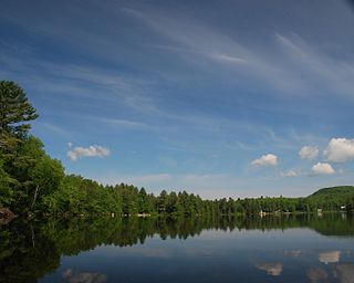
Ricker Pond State Park is a state park in Groton, Vermont in the United States. It is one of seven state parks located in Groton State Forest. The park is just off Vermont Route 232. The park provides public access to Ricker Pond, a 95-acre (38 ha) lake in central Groton, and was developed in the 1930s by crews of the Civilian Conservation Corps. Activities includes camping, motor boating, waterskiing, fishing, swimming, paddling, horseback riding, hiking, mountain biking, snowshoeing and cross-country skiing. The park is open between the Memorial Day and Columbus Day weekends; fees are charged for day use and camping.
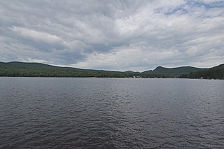
Bomoseen State Park is a 3,576-acre state park in the towns of Castleton, Fair Haven, Hubbarton and Benson, Vermont. The park is located in the Taconic Mountains on the western shore of Lake Bomoseen.

Underhill State Park is a state park in Underhill, Vermont. It is situated on the west slope of 4,300 feet Mount Mansfield, in the 39,837-acre Mount Mansfield State Forest. Activities includes hiking, camping, mountain biking, stream fishing, wildlife watching, and picnicking. Facilities include group and individual camping areas, a picnic shelter, and hiking trails. The park is formally open between Memorial Day weekend and Columbus Day weekend, but is accessible for periods outside those times; fees are charged. Much of the park's infrastructure was built by the Civilian Conservation Corps (CCC) in the 1930s; these facilities were listed on the National Register of Historic Places in 2002.
Thetford Hill State Park is a state park in Thetford, Vermont. It is a day-use park within the southern tract of Thetford Hill State Forest. The park includes paths for hiking and the 5-km Woods Hill Trail, a world-class cross-country running and skiing trail. Activities includes hiking, cross-country running and cross-country skiing. The park was listed on the National Register of Historic Places in 2002 for its historic facilities, some of which were developed by the Civilian Conservation Corps. It is currently under the care of Thetford Academy.
Mount Ascutney State Park is a state park in the U.S. state of Vermont. The park entrance is located along Vermont Route 44-A near the town of Windsor in Windsor County. Operated by the Vermont Department of Forests, Parks and Recreation, a significant portion of the park is listed on the National Register of Historic Places.


