
The Appalachian National Scenic Trail, generally known as the Appalachian Trail or simply the A.T., is a marked hiking trail in the Eastern United States extending between Springer Mountain in Georgia and Mount Katahdin in Maine. The trail passes through 14 states and is about 2,200 miles (3,500 km) long, though the exact length changes over time as parts are rerouted or modified. The Appalachian Trail Conservancy describes the Appalachian Trail as the longest hiking-only trail in the world. More than two million people are said to take a hike on part of the trail at least once each year.

Clarendon is a town in Rutland County, Vermont, United States. The population was 2,412 at the 2020 census. Clarendon spans U.S. Route 7 and is split by the highway, the Cold River and Mill River, Otter Creek, and the Green Mountains into the hamlets of Clarendon, West Clarendon, East Clarendon, Clarendon Springs, and North Clarendon

The North Country National Scenic Trail, generally known as the North Country Trail or simply the NCT, is a footpath stretching over 4,800 miles (7,700 km) from Middlebury in central Vermont to Lake Sakakawea State Park in central North Dakota in the United States; connecting both the Long Trail and the Appalachian Trail with the Lewis and Clark Trail. Passing through the eight states of Vermont New York, Pennsylvania, Ohio, Michigan, Wisconsin, Minnesota and North Dakota, it is the longest of the eleven National Scenic Trails authorized by Congress. As of early 2019, 3,129 miles (5,036 km) of the trail is in place.

Multnomah Falls is a waterfall located on Multnomah Creek in the Columbia River Gorge, east of Troutdale, between Corbett and Dodson, Oregon, United States. The waterfall is accessible from the Historic Columbia River Highway and Interstate 84. Spanning two tiers on basalt cliffs, it is the tallest waterfall in the state of Oregon at 620 ft (189 m) in height. The Multnomah Creek Bridge, built in 1914, crosses below the falls, and is listed on the National Register of Historic Places.

The Berkshires are a highland geologic region located in the western parts of Massachusetts and northwest Connecticut. The term "Berkshires" is normally used by locals in reference to the portion of the Vermont-based Green Mountains that extend south into western Massachusetts; the portion extending further south into northwestern Connecticut is grouped with the Connecticut portion of the Taconic Mountains and referred to as either the Northwest Hills or Litchfield Hills.

The Taconic Mountains or Taconic Range are a range of the Appalachian Mountains, running along the eastern border of New York State and adjacent New England from northwest Connecticut to western Massachusetts, north to central western Vermont. A physiographic region of the larger New England province, the range includes notable summits, including its high point, 3,840 feet (1,170 m) Mount Equinox in Vermont, and 3,489 feet (1,063 m) Mount Greylock, the highest point in Massachusetts.
The protected areas of Michigan come in an array of different types and levels of protection. Michigan has five units of the National Park Service system. There are 14 federal wilderness areas; the majority of these are also tribal-designated wildernesses. It has one of the largest state forest systems as well having four national forests. The state maintains a large state park system and there are also regional parks, and county, township and city parks. Still other parks on land and in the Great Lakes are maintained by other governmental bodies. Private protected areas also exist in the state, mainly lands owned by land conservancies.

Oneonta Gorge is a scenic gorge located in the Columbia River Gorge area of the American state of Oregon. The U.S. Forest Service has designated it as a botanical area because of the unique aquatic and woodland plants that grow there. Exposed walls of 25-million-year-old basalt are home to a wide variety of ferns, mosses, hepatics, and lichens, many of which grow only in the Columbia River Gorge. Oneonta Gorge with its 50 species of wildflowers, flowering shrubs and trees has been described as "one of the true dramatic chasms in the state." The Oneonta Gorge Creek Bridge is listed on the National Register of Historic Places.

The New River Gorge National Park and Preserve is a unit of the United States National Park Service (NPS) designed to protect and maintain the New River Gorge in southern West Virginia in the Appalachian Mountains. Established in 1978 as a national river and redesignated in 2020, the park and preserve stretches for 53 miles (85 km) from just downstream of Hinton to Hawks Nest State Park near Ansted. The park is rich in cultural and natural history, and offers an abundance of scenic and recreational opportunities. New River Gorge is home to some of the country's best whitewater rafting, mainly from the Cunard put-in to the Fayette Station take-out, and is also one of the most popular climbing areas on the East Coast.
The Klickitat Trail is a 31-mile (50 km) rail trail along the Klickitat River in southern Washington in the Columbia River Gorge. The cycling and hiking trail offers river and canyon views throughout its length. It follows an old railroad corridor that at one time linked the towns of Lyle and Goldendale.
The Appalachian National Scenic Trail spans fourteen U.S. states during its roughly 2,200 miles (3,500 km)-long journey: Georgia, North Carolina, Tennessee, Virginia, West Virginia, Maryland, Pennsylvania, New Jersey, New York, Connecticut, Massachusetts, Vermont, New Hampshire, and Maine. The southern end is at Springer Mountain, Georgia, and it follows the ridgeline of the Appalachian Mountains, crossing many of its highest peaks and running almost continuously through wilderness before reaching the northern end at Mount Katahdin, Maine.

Beury Mountain Wildlife Management Area is located on 9,232 acres (3,736 ha) near Babcock State Park and New River Gorge National River in Fayette County, West Virginia. Beury Mountain's sloping terrain is covered with mixed hardwoods and oak-hickory second growth woodlands overlooking New River Gorge. Camping is not allowed at Beury Mountain WMA, but is available at nearby Babcock State Park.

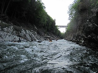
The Mianus River Gorge is a 935-acre (3.78 km2) nature preserve in Bedford, New York jointly owned by The Nature Conservancy and Mianus River Gorge, Inc.. The first 60 acres (0.24 km2) were purchased by the Preserve, with help from the Conservancy, their first land preservation deal. It has grown over the years and is still managed by Mianus River Gorge, Inc. In March 1964, it was designated a National Natural Landmark for its old growth climax hemlock forest and the gorge of the Mianus River.

Thousand Springs State Park is a public recreation and nature preservation area consisting of multiple units — Billingsley Creek, Earl M. Hardy Box Canyon Springs Nature Preserve, Malad Gorge, Niagara Springs, and Ritter Island — in Gooding County, Idaho.
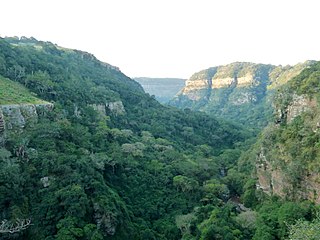
The Krantzkloof Nature Reserve, managed by Ezemvelo KZN Wildlife, conserves 668 ha of the Molweni and Nkutu River gorges that incise the sandstone Kloof plateau in KwaZulu-Natal, South Africa. The reserve conserves coastal scarp forest, sourveld grassland, a cliff face biotope, and aquatic environments along its rivers. Scarp forest is a threatened forest type, protected by South Africa's forests act of 1998, while the grassland is classified as KwaZulu-Natal sandstone sourveld, the most threatened terrestrial habitat in the Durban metropole. The reserve was established in 1950 and was augmented by land donations as late as 1999.
The Quechee State Park is located on US Route 4 in Quechee, Vermont. The park land is owned by the US Army Corps of Engineers and leased from by the State of Vermont. The park contains the Quechee Gorge, a popular Vermont tourist stop. The land was originally the site of the Dewey wool mill which ceased operation in 1952 and relocated to Enfield, New Hampshire. Shortly after the closing of the Mill the US Army Corps of Engineers acquired the property as part of its regional flood control plan. A hydroelectric dam sits at the north end of the gorge.
Jim Jeffords State Forest covers 1,349 acres (5.46 km2) in Mendon and Shrewsbury, Vermont. The forest connects Aitken State Forest, to the east, and Calvin Coolidge State Forest, to the west, contributing to the conservation of an important wildlife corridor.
