
Mount Mansfield is the highest mountain in Vermont with a summit that peaks at 4,395 feet (1,340 m) above sea level. The summit is located within the town of Underhill in Chittenden County; the ridgeline, including some secondary peaks, extends into the town of Stowe in Lamoille County, and the mountain's flanks also reach into the town of Cambridge.

Wilgus State Park is a state park in Ascutney, Vermont. The park offers canoeing along the Connecticut River and hiking up the Pinnacle Trail. The park has tent and lean-to sites and is quite close to Mount Ascutney and the Saint-Gaudens National Historic Site. The park was originally constructed by the Civilian Conservation Corps (CCC) and is now administered by the Vermont Department of Forests, Parks, and Recreation as part of the Vermont state park system. It is named after William J. Wilgus, who donated the land for the park in 1933. The park is listed on the National Register of Historic Places for its well-preserved CCC infrastructure.

Kooser State Park is a 250-acre (101 ha) Pennsylvania state park in Jefferson Township, Somerset County, Pennsylvania, in the United States. The park, which borders Forbes State Forest, was built in the 1930s by the Civilian Conservation Corps, who also built the 4-acre (1.6 ha) Kooser Lake by damming Kooser Run. Kooser State Park is on Pennsylvania Route 31 a one-hour drive from Pittsburgh. The park is surrounded by Forbes State Forest.

Table Rock State Park is a 3,083-acre (12.48 km2) park at the edge of the Blue Ridge Mountains in northern Pickens County, South Carolina. The park includes Pinnacle Mountain, the tallest mountain totally within the state.

Backbone State Park is Iowa's oldest state park, dedicated in 1919. Located in the valley of the Maquoketa River, it is approximately three miles (5 km) south of Strawberry Point in Delaware County. It is named for a narrow and steep ridge of bedrock carved by a loop of the Maquoketa River originally known as the Devil's Backbone. The initial 1,200 acres (490 ha) were donated by E.M. Carr of Lamont, Iowa. Backbone Lake Dam, a relatively low dam built by the Civilian Conservation Corps (CCC) in the 1930s, created Backbone Lake. The CCC constructed a majority of trails and buildings which make up the park.

Elmore State Park is a state park located in Elmore, Vermont, United States. It includes Lake Elmore and Elmore Mountain, and has day-use facilities for picnicking, hiking, and water-based activities, and a 59-site campground. Some of its facilities were developed in the 1930s by the Civilian Conservation Corps; for these, it was listed on the National Register of Historic Places in 2002. The park is open seasonally between Memorial Day and Columbus Day; fees are charged for day use and camping.
Mount Philo State Park is a state park located in Charlotte, Vermont. The 237-acre (0.96 km2) park protects the area around Mount Philo and provides views of Lake Champlain and the Adirondack Mountains to the west. The Green Mountains can be seen to the east and south. It is accessed by trail or steep narrow road (seasonal).

Coolidge State Park is a Vermont State Park located in Plymouth, Vermont, United States. The park is named after Calvin Coolidge, the 30th President of the United States, who was born and raised in Plymouth and is buried there as well. It is the primary recreational center for Calvin Coolidge State Forest, the largest state forest in Vermont. The park's facilities, built by the Civilian Conservation Corps (CCC) in the 1930s, are listed on the National Register of Historic Places.

Osage Hills State Park is a 1,100-acre (4.5 km2) Oklahoma state park It is located in eastern Osage County, Oklahoma. The nearest cities are Pawhuska and Bartlesville. The park offers outdoor recreation opportunities including camping, hiking, fishing and wildlife watching. Park facilities include picnic tables and shelters, 20 semi-modern RV campsites, 16 tent sites and 8 cabins. Several of the park's structures are historic parkitecture built by the Civilian Conservation Corps during the 1930s and 1940s.

Townshend State Park is a state park in Townshend, Vermont. Embedded within Townshend State Forest, the park provides a camping facility and hiking trails for accessing Bald Mountain. The park's facilities were developed by the Civilian Conservation Corps in the 1930s, and are listed on the National Register of Historic Places for their well-preserved state.

Gifford Woods State Park is a state park located at the base of Pico Peak in Killington, Vermont. The wooded park provides camping, picnic, and fishing facilities, and has hiking trails, including a portion of the Appalachian Trail. It preserves an area of old-growth forest that has been designated a National Natural Landmark, and is accessible via an interpretive trail. The park was established in 1931. Part of it is listed on the National Register of Historic Places, for facilities developed by the Civilian Conservation Corps in the 1930s.

Allis State Park is a state park in Brookfield, Vermont. Established in 1928, Allis State Park was the second state park to be created in Vermont. It is named for Wallace Allis, who willed his Bear Mountain Farm to the State of Vermont to be developed as a campground and recreational area. The park was developed by the Civilian Conservation Corps (CCC) beginning in 1932, which built the access roads, constructed a picnic shelter, picnic grounds and a campground. There is a fire/lookout tower on Bear Hill. Limited trash service, hot showers and running water are available. There are picnic tables, grills and fireplaces.
Stillwater State Park is a state park located on Lake Groton in Groton, Vermont. The park is located in Groton State Forest close to the Groton Nature Center, Boulder Beach State Park and Big Deer State Park. The park offers camping, picnicking, and access to water-related activities on Lake Groton. The park was developed in the 1930s by crews of the Civilian Conservation Corps (CCC). It is open to the public between Memorial Day weekend and Columbus Day weekend; fees are charged for day use and camping.

New Discovery State Park is a state park near Marshfield, Vermont in the United States. It is one of seven state parks located in Groton State Forest. The park is on Vermont Route 232, offering camping, picnicking, and access to forest trails. The park was developed in the 1930s by the Civilian Conservation Corps; its major CCC-built facilities, located mainly in western Peacham, were listed on the National Register of Historic Places in 2002.
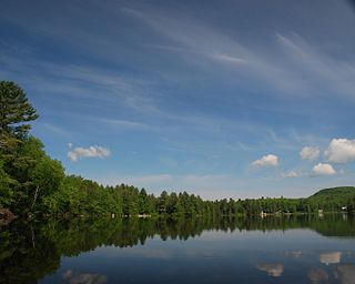
Ricker Pond State Park is a state park in Groton, Vermont in the United States. It is one of seven state parks located in Groton State Forest. The park is just off Vermont Route 232. The park provides public access to Ricker Pond, a 95-acre (38 ha) lake in central Groton, and was developed in the 1930s by crews of the Civilian Conservation Corps. Activities includes camping, motor boating, waterskiing, fishing, swimming, paddling, horseback riding, hiking, mountain biking, snowshoeing and cross-country skiing. The park is open between the Memorial Day and Columbus Day weekends; fees are charged for day use and camping.
Thetford Hill State Park is a state park in Thetford, Vermont. It is a day-use park within the southern tract of Thetford Hill State Forest. The park includes paths for hiking and the 5-km Woods Hill Trail, a world-class cross-country running and skiing trail. Activities includes hiking, cross-country running and cross-country skiing. The park was listed on the National Register of Historic Places in 2002 for its historic facilities, some of which were developed by the Civilian Conservation Corps. It is currently under the care of Thetford Academy.

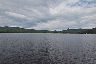
Maidstone State Park is a state park in the U.S. state of Vermont. The park is located in the town of Maidstone in Essex County in Vermont's Northeast Kingdom. One of the state's most remote parks, it provides public access to the 796-acre (322 ha) glacial Maidstone Lake in Maidstone State Forest. The park was developed by the Civilian Conservation Corps and opened in 1938. Activities include fishing, hiking, camping, boating, wildlife watching, and picnicking. The park is open from Memorial Day weekend to Columbus Day weekend; fees are charged for day use and camping.

Jamaica State Park is a 772-acre state park in Jamaica, Vermont, on the shore of the West River.
Mount Ascutney State Park is a state park in the U.S. state of Vermont. The park entrance is located along Vermont Route 44-A near the town of Windsor in Windsor County. Operated by the Vermont Department of Forests, Parks and Recreation, a significant portion of the park is listed on the National Register of Historic Places.

Mount Mansfield State Forest covers 44,444 acres (179.86 km2) in seven towns in Chittenden, Lamoille and Washington counties in Vermont. The towns are Bolton and Underhill in Chittenden County, Cambridge, Johnson, Morristown and Stowe in Lamoille County, and Waterbury in Washington County. Mt. Mansfield State Forest is the largest contiguous landholding owned by the Vermont Department of Forests, Parks and Recreation.


