Mount Mansfield State Forest

Last updated
Mount Mansfield State Forest

MtMansfieldStateForest 201008 (14130254932).jpg

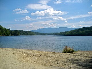
View of Underhill State Park & Smugglers' Notch State Park (background)
Type State forest
Location Chittenden, Lamoille and Washington County, Vermont
Coordinates 44°29′30″N72°49′07″W / 44.4918°N 72.8186°W / 44.4918; -72.8186 Coordinates: 44°29′30″N72°49′07″W / 44.4918°N 72.8186°W / 44.4918; -72.8186
Area 44,444 acres (179.86 km2)
Operated by Vermont Department of Forests, Parks, and Recreation
Website Website

Mount Mansfield State Forest covers 44,444 acres (179.86 km2) in seven towns in Chittenden, Lamoille and Washington counties in Vermont. [1] The towns are Bolton and Underhill in Chittenden County, Cambridge, Johnson, Morristown and Stowe in Lamoille County, and Waterbury in Washington County. Mt. Mansfield State Forest is the largest contiguous landholding owned by the Vermont Department of Forests, Parks and Recreation.

Chittenden County, Vermont County in the United States

Chittenden County is the most populous county in the U.S. state of Vermont. As of the 2010 census, the population was 156,545. The county's population estimate for 2016 was 161,531. Its shire town (seat) is Vermont's most populous municipality, the city of Burlington. The county has over a quarter of Vermont's population and more than twice the population of Vermont's second most populous county, Rutland. The county also has more than twice the population density of Vermont's second most dense county, Washington. The county is named for Vermont's first governor and one of the framers of its constitution as an independent republic and later U.S. state, Thomas Chittenden.

Lamoille County, Vermont County in the United States

Lamoille County is a county located in the U.S. state of Vermont. As of the 2010 census, the population was 24,475, making it the third-least populous county in Vermont. Its shire town is the town of Hyde Park. The county was created in 1835 and organized the following year.

Washington County, Vermont County in the United States

Washington County is a county located in the U.S. state of Vermont. Named after George Washington, its county seat is the city of Montpelier, the least populous state capital in the United States, and the most populous municipality is Barre. As of the 2010 census, the population was 59,534, making it the third-most populous county in Vermont, but the third-least populous capital county in the United States after Hughes County, South Dakota and Franklin County, Kentucky. If Carson City, Nevada and Juneau, Alaska were to be treated as counties, Washington County would be the fifth-least populous capital county.

Contents

Recreation

There are four state parks located in the forest: Little River State Park, Smugglers' Notch State Park, Underhill State Park and Waterbury Center State Park. Activities include camping, swimming, boating, fishing, hiking, picnicking, bicycling, wildlife watching, and winter sports.

Little River State Park

Little River State Park is a campground state park on the 850-acre Waterbury Reservoir in Waterbury, Vermont. It is located in Mount Mansfield State Forest.

Smugglers Notch State Park

Smugglers' Notch State Park is a Vermont state park near Stowe in Lamoille County, Vermont, United States. The park is at an elevation of 2,119 feet (646 m) near Mount Mansfield, and is named for Smugglers Notch, which separates Mount Mansfield—the highest peak of the Green Mountains—from Spruce Peak and the Sterling Range.

Underhill State Park

Underhill State Park is a state park in Underhill, Vermont. It is situated on the west slope of 4,300 feet Mount Mansfield, in the 39,837-acre Mount Mansfield State Forest. Activities includes hiking, camping, mountain biking, stream fishing, wildlife watching, and picnicking. Facilities include group and individual camping areas, a picnic shelter, and hiking trails. The park is formally open between Memorial Day weekend and Columbus Day weekend, but is accessible for periods outside those times; fees are charged. Much of the park's infrastructure was built by the Civilian Conservation Corps (CCC) in the 1930s; these facilities were listed on the National Register of Historic Places in 2002.

The alpine ski resorts of Smugglers' Notch and Stowe Mountain Resort are located in the forest. There are two Nordic ski centers – Mt. Mansfield Touring Center and Bolton Nordic Center at Bolton Valley. The Catamount Trail Association manages backcountry ski trails in the Forest. There are over 36 miles of VAST snowmobile trails throughout the Forest and mountain biking trails in the southern end.

Stowe Mountain Resort

Stowe Mountain Resort is a ski resort in the northeastern United States, near the town of Stowe in northern Vermont, comprising two separate mountains: Mount Mansfield and Spruce Peak. The lift-served vertical drop of Mount Mansfield is 2,360 feet (719 m), the fifth largest in New England and the fourth largest in Vermont.

Bolton Valley

Bolton Valley is a mid-sized ski area in the town of Bolton in Chittenden County, Vermont, United States. It is located in close proximity to Burlington, the largest city in the state of Vermont.

The Vermont Association of Snow Travelers, Inc. (VAST) was founded in 1967 and is responsible for the organization of the sport of snowmobiling, maintaining and grooming over 5,000 miles of trails in the state of Vermont. Based in Berlin, Vermont, VAST is a non-profit, private organization that includes over 120 clubs statewide, with over 24,000 members combined. Over 80% of the trails are on private land, and the clubs obtain landowner permission for trails on private property.

There are numerous miles of hiking trails that include the Long Trail and hikes up and around Mount Mansfield. [2] [3]

Long Trail footpath in the American state of Vermont

The Long Trail is a hiking trail located in Vermont, running the length of the state. It is the oldest long-distance trail in the United States, constructed between 1910 and 1930 by the Green Mountain Club. The club remains the primary organization responsible for the trail, and is recognized by the state legislature as "the founder, sponsor, defender, and protector" of the Long Trail System.

The 880-acre Waterbury Reservoir features three motorboat access points and one car-top boat access point. There are remote campsites along the shores of the Reservoir that are being developed as the Department partners with the Friends of Waterbury Reservoir. Primitive camping is allowed on various portions of Mt. Mansfield State Forest, following the developed guidelines.

The Waterbury Dam was built between 1935-1938 by 2,000 men working for the Corps of Engineers, United States Army, to serve as one of three dams to control the flow of Little River, Vermont, Winooski River and its tributaries. In 1927, flood waters from the Winooski River killed over 55 people and caused an estimated $13,000,000 in damage. Along with flood control, the dam also generates electric energy, generating an average of 15,000,000 kilowatt-hours (54,000,000 MJ) annually.

Hunting, fishing and trapping are allowed throughout the Forest.

Features

Mt. Mansfield State Forest features and is named for Mount Mansfield, the highest peak in Vermont at 4,393-feet. The 400-acre summit ridge is actually owned by the University of Vermont.

Mount Mansfield mountain

Mount Mansfield is the highest mountain in Vermont with a summit that peaks at 4,395 feet (1,340 m) above sea level. The summit is located within the town of Underhill in Chittenden County; the ridgeline, including some secondary peaks, extends into the town of Stowe in Lamoille County, and the mountain's flanks also reach into the town of Cambridge.

University of Vermont public research university in Burlington, Vermont, USA

The University of Vermont (UVM), officially The University of Vermont and State Agricultural College, is a public research university and, since 1862, the sole land-grant university in the U.S. state of Vermont. Founded in 1791, UVM is among the oldest universities in the United States and is the fifth institution of higher education established in the New England region of the U.S. northeast. It is also listed as one of the original eight "Public Ivy" institutions in the United States.

The forest contains two State Natural Areas - Daniels Notch Natural Area (100 acres (0.40 km2)) and Mt. Mansfield Natural Area (3,850 acres (15.6 km2)). [4]

Smugglers' Notch Proper is listed as a National Natural Landmark.

Vermont Route 108 between Stowe Mountain Resort and Smugglers' Notch Resort is a federally designated Scenic By-way.

Related Research Articles

Underhill, Vermont Town in Vermont, United States

Underhill is a town in Chittenden County, Vermont, United States. The population was 3,016 at the 2010 census.

Stowe, Vermont Town in Vermont, United States

Stowe is a town in Lamoille County, Vermont, United States. The population was 4,314 at the 2010 census. The town lies on Vermont Route 108, locally known as the Mountain Road. It is nicknamed 'The Ski Capital of the East' and is home to Stowe Mountain Resort, a ski facility with terrain on Mount Mansfield and Spruce Peak.

Jericho, Vermont Town in Vermont, United States

Jericho is a town in Chittenden County, Vermont, United States. The population was 5,009 at the 2010 census. It was named after the ancient city of Jericho.

Smugglers Notch Resort

Smugglers' Notch Resort is a ski resort area in the town of Cambridge, Vermont, United States, located near the village of Jeffersonville. Its vertical drop of 2,610 feet (800 m) is the fourth largest in New England and the third largest in Vermont. Its namesake is a narrow notch running adjacent to Sterling Mountain, which smugglers used many years ago. Smugglers' Notch, nicknamed Smuggs, consists of three mountains: Morse, Madonna, and Sterling. The resort attracts skiers in the winter and summer vacationers during the warmer months.

Smugglers Notch

Smugglers' Notch is a mountain pass in Lamoille County, Vermont. The notch separates Mount Mansfield, the highest peak of the Green Mountains, from Spruce Peak and the Sterling Range. Most of the notch is in Mount Mansfield State Forest.

Vermont Route 108 highway in Vermont

Vermont Route 108 is a north–south state highway in northern Vermont, United States. Its southern terminus is at VT 100 in Stowe, and its northern terminus is at the Canada–US border in Franklin, where it continues into Quebec past the West Berkshire–Frelighsburg Border Crossing as Route 237. VT 108 is 45.450 miles (73.145 km) long.

Waterbury Center State Park is a 90-acre day-use state park on the 850-acre Waterbury Reservoir in Waterbury Center, Vermont. It is located in Mount Mansfield State Forest.

Calvin Coolidge State Forest, also known as Coolidge State Forest, covers 22,564 acres (91.31 km2) in two parts in Rutland and Windsor Counties in Vermont. The West portion cover 17,259 acres (69.84 km2) in Killington, Mendon, Plymouth and Shrewsbury in both counties. The East portion cover 5,305 acres (21.47 km2) in Bridgewater, Plymouth, Reading, and Woodstock in Windsor County.

Stowe CCC Side Camp building in Vermont, United States

The Stowe CCC Side Camp, now known as the Vermont State Ski Dorm, is a historic residence hall at 6992 Mountain Road in Stowe, Vermont. Built in 1935 by crews of the Civilian Conservation Corps, it is one of the largest surviving CCC-built housing units to survive in the state. It was converted for use as a ski lodge after World War II. It was listed on the National Register of Historic Places in 2002.

Stowe Village Historic District

The Stowe Village Historic District encompasses most of the village center of Stowe, Vermont. The village has since the 19th century been one of Vermont's major resort centers, and its center is architecturally reflective of this history, It was listed on the National Register of Historic Places in 1978.

Putnam State Forest, officially known as C.C. Putnam State Forest, covers 13,633 acres (55.17 km2) in Lamoille and Washington County in Vermont. The forest is managed by the Vermont Department of Forests, Parks, and Recreation in parts of Stowe, Elmore, Waterbury, Worcester and Middlesex.

Willoughby State Forest

Willoughby State Forest covers 7,682 acres (31.09 km2) in Newark, Sutton and Westmore in Caledonia and Orleans counties in Vermont. The forest is managed by the Vermont Department of Forests, Parks, and Recreation. Activities include hiking, primitive camping, cross country skiing, snowshoeing, hunting and fishing.

Okemo State Forest covers 7,466 acres (30.21 km2) in Andover, Ludlow, Mount Holly and Weston, Vermont in Windsor and Rutland Counties. Okemo Mountain Resort is located in the forest. The forest is managed by the Vermont Department of Forests, Parks, and Recreation.

Long Trail State Forest protects 9,529 acres (38.56 km2) around a portion of the Long Trail, a 271 mi (436 km) hiking trail in Vermont. The forest runs through Belvidere, Eden, Lowell, Johnson, Montgomery, Waterville and Westfield in Franklin, Lamoille and Orleans counties. The forest is managed by the Vermont Department of Forests, Parks, and Recreation in partnership with the Green Mountain Club.

Jay State Forest covers 7,951 acres (32.18 km2) in two tracts in Jay, Richford, Montgomery and Westfield in Franklin and Orleans counties in Vermont. The forest is managed by the Vermont Department of Forests, Parks, and Recreation.

References

  1. "Mount Mansfield State Forest". Vermont Dept. of Forests, Parks and Recreation. Retrieved 14 February 2017.
  2. "Best Trails in Mount Mansfield State Forest". All Trails. Retrieved 14 February 2017.
  3. "Mount Mansfield". Summit Post. Retrieved 14 February 2017.
  4. "Natural Areas". VT Dept. of Forests, Parks and Recreation. Retrieved 14 February 2017.