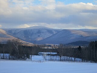
Mount Greylock is a 3,489-foot (1,063-meter) mountain located in the northwest corner of Massachusetts and is the highest point in the state. Its summit is in the western part of the town of Adams in Berkshire County. Technically, Mount Greylock is geologically part of the Taconic Mountains, which are not associated with the abutting Berkshire Mountains to the east. The mountain is known for its expansive views encompassing five states and the only taiga-boreal forest in the state. A seasonal automobile road climbs to the summit, topped by a 93-foot-high (28 m) lighthouse-like Massachusetts Veterans War Memorial Tower. A network of hiking trails traverses the mountain, including the Appalachian Trail. Mount Greylock State Reservation was created in 1898 as Massachusetts' first public land for the purpose of forest preservation.
Monroe State Forest is a publicly owned forest with recreational features located in the New England towns of Monroe and Florida, Massachusetts, USA. A small portion of the state forest borders the state of Vermont. The forest is managed by the Department of Conservation and Recreation.

Wilgus State Park is a state park in Ascutney, Vermont. The park offers canoeing along the Connecticut River and hiking up the Pinnacle Trail. The park has tent and lean-to sites and is quite close to Mount Ascutney and the Saint-Gaudens National Historic Site. The park was originally constructed by the Civilian Conservation Corps (CCC) and is now administered by the Vermont Department of Forests, Parks, and Recreation as part of the Vermont state park system. It is named after William J. Wilgus, who donated the land for the park in 1933. The park is listed on the National Register of Historic Places for its well-preserved CCC infrastructure.

Putnam Memorial State Park is a history-oriented public recreation area in the town of Redding, Connecticut. The state park preserves the site that Major General Israel Putnam chose as the winter encampment for his men in the winter of 1778/1779 during the American Revolutionary War. It is Connecticut's oldest state park, created in 1887 at the instigation of Redding town residents. The park was listed on the National Register of Historic Places in 1970.
Mount Putnam is a mountain located on the border between Washington County and Lamoille County, Vermont, in the Putnam State Forest. Mount Putnam, the high point of the Worcester Range, is flanked to the northeast by Mount Worcester, and to the southwest by Mount Hunger. It is the sixth most prominent peak in Vermont. The summit is in Washington County, but the mountain extends into Lamoille County as well.

Camel's Hump State Park is a state park in the U.S. state of Vermont. The park straddles the northern Green Mountains in an area bounded by Vermont Route 17 on the south and the Winooski River on the north. As of 2017, the park covered a total of 21,224 acres (8,589 ha), making it the largest state park in Vermont.

Groton State Forest covers 26,164 acres (105.88 km2) in Danville, Groton, Marshfield, Orange, Peacham, Plainfield, Topsham, Vermont. The forest covers areas in Caledonia, Orange, and Washington Counties. Major roads through the forest are U.S. Route 302 and Vermont Route 232.

Jamaica State Park is a 772-acre state park in Jamaica, Vermont, on the shore of the West River.
Mount Ascutney State Park is a state park in the U.S. state of Vermont. The park entrance is located along Vermont Route 44-A near the town of Windsor in Windsor County. Operated by the Vermont Department of Forests, Parks and Recreation, a significant portion of the park is listed on the National Register of Historic Places.
Aitken State Forest covers 918 acres (3.72 km2) in Mendon, Vermont in Rutland County. The forest is managed by the Vermont Department of Forests, Parks, and Recreation for timber resources, wildlife habitat, and recreational activities.
Black Turn Brook State Forest covers 592 acres (2.40 km2) in Norton, Vermont in Essex County near the Canadian border. The forest is managed by the Vermont Department of Forests, Parks, and Recreation. The parcel is adjacent to the Coaticook River and access is via a right-of-way across privately owned property.
Camel's Hump State Forest covers a total of 2,323 acres (9.40 km2) in two blocks in the U.S. state of Vermont. Stevens Block comprises 1,680 acres (6.8 km2) in Buels Gore, Fayston, and Starksboro in Chittenden, Washington, and Addison counties, respectively. Howe Block covers 643 acres (2.60 km2) in Waitsfield and Fayston, both in Washington county. The forest is managed by the Vermont Department of Forests, Parks and Recreation.
Putnam State Forest, officially known as C.C. Putnam State Forest, covers 13,633 acres (55.17 km2) in Lamoille and Washington County in Vermont. The forest is managed by the Vermont Department of Forests, Parks, and Recreation in parts of Stowe, Elmore, Waterbury, Worcester and Middlesex.

Willoughby State Forest covers 7,682 acres (31.09 km2) in Newark, Sutton and Westmore in Caledonia and Orleans counties in Vermont. The forest is managed by the Vermont Department of Forests, Parks, and Recreation. Activities include hiking, primitive camping, cross country skiing, snowshoeing, hunting and fishing.
Williams River State Forest covers 108 acres (0.44 km2) in Chester in Windham County, Vermont. The forest is managed by the Vermont Department of Forests, Parks, and Recreation.
William C. Putnam State Forest covers 146 acres (0.59 km2) in Grafton in Windham County, Vermont. The forest is managed by the Vermont Department of Forests, Parks, and Recreation.

Mount Mansfield State Forest covers 44,444 acres (179.86 km2) in seven towns in Chittenden, Lamoille and Washington counties in Vermont. The towns are Bolton and Underhill in Chittenden County, Cambridge, Johnson, Morristown and Stowe in Lamoille County, and Waterbury in Washington County. Mt. Mansfield State Forest is the largest contiguous landholding owned by the Vermont Department of Forests, Parks and Recreation.
Big Falls of the Missisquoi Natural Area is an Orleans County, Vermont recreation area for swimming, fishing, and sight-seeing. The area also has a lot of old-growth hemlock plants and pine trees. Currently an undeveloped site near the small rural town of Troy, the falls is composed of 16 acres (6.5 ha) on both sides of the Missisquoi River, 2,400 feet (730 m) of which is frontage. Classified as a Vermont Natural Area protected site, the area is managed by the Vermont Department of Forests, Parks and Recreation.