
The Connecticut River is the longest river in the New England region of the United States, flowing roughly southward for 406 miles (653 km) through four states. It rises 300 yards south of the U.S. border with Quebec, Canada, and discharges at Long Island Sound. Its watershed encompasses 11,260 square miles (29,200 km2), covering parts of five U.S. states and one Canadian province, via 148 tributaries, 38 of which are major rivers. It produces 70% of Long Island Sound's fresh water, discharging at 18,400 cubic feet (520 m3) per second.

Glen Canyon Dam is a concrete arch-gravity dam in the southwestern United States, located on the Colorado River in northern Arizona, near the town of Page. The 710-foot-high (220 m) dam was built by the Bureau of Reclamation (USBR) from 1956 to 1966 and forms Lake Powell, one of the largest man-made reservoirs in the U.S. with a capacity of more than 25 million acre-feet (31 km3). The dam is named for Glen Canyon, a series of deep sandstone gorges now flooded by the reservoir; Lake Powell is named for John Wesley Powell, who in 1869 led the first expedition to traverse the Colorado River's Grand Canyon by boat.
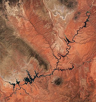
Lake Powell is an artificial reservoir on the Colorado River in Utah and Arizona, United States. It is a major vacation destination visited by approximately two million people every year. It is the second largest artificial reservoir by maximum water capacity in the United States behind Lake Mead, storing 24,322,000 acre-feet (3.0001×10¹⁰ m3) of water when full. However, Lake Mead has fallen below Lake Powell in size several times during the 21st century in terms of volume of water, depth and surface area.

Toledo Bend Reservoir is a reservoir on the Sabine River between Texas and Louisiana. The lake has an area of 185,000 acres (750 km2), the largest man-made body of water partially in both Louisiana and Texas, the largest in the South, and the fifth largest by surface acre in the United States. The dam is capable of generating 92 megawatts of electrical power. The dam itself is located in the northeast corner of Newton County, Texas; however, that county includes very little of the reservoir, as most of it extends northward into parts of Sabine and DeSoto parishes in Louisiana, and Sabine, Shelby, and Panola counties in Texas.

Southampton Common is a large open space to the north of the city centre of Southampton, England. It is bounded by the districts of Shirley, Bassett, Highfield and Portswood. The area supports a large variety of wildlife, including one of the largest populations in Britain of the nationally rare great crested newt. The Common is used for a wide variety of community events, Flower Festival, Race for life Cancer Research UK and formerly 'Power in the Park' hosted by Power FM.

The San Luis Reservoir is an artificial lake on San Luis Creek in the eastern slopes of the Diablo Range of Merced County, California, approximately 12 mi (19 km) west of Los Banos on State Route 152, which crosses Pacheco Pass and runs along its north shore. It is the fifth largest reservoir in California. The reservoir stores water taken from the San Joaquin-Sacramento River Delta. Water is pumped uphill into the reservoir from the O'Neill Forebay which is fed by the California Aqueduct and is released back into the forebay to continue downstream along the aqueduct as needed for farm irrigation and other uses. Depending on water levels, the reservoir is approximately nine miles (14 km) long from north to south at its longest point, and five miles (8 km) wide. At the eastern end of the reservoir is the San Luis Dam, the fourth largest embankment dam in the United States, which allows for a total capacity of 2,041,000 acre-feet (2,518,000 dam3). Pacheco State Park lies along its western shores.

Spruce Run Recreation Area is a 1,290-acre (5.2 km2) New Jersey state recreation area located in Union Township and Clinton Township in Hunterdon County, New Jersey, United States. It encompasses the Spruce Run Reservoir that is used as a backup reservoir to protect the state from prolonged droughts. The reservoir is the third largest in the state, after Round Valley and Wanaque Reservoir. The reservoir is used for recreation purposes, including hunting, fishing, boating and swimming.

Lake James is a large reservoir in the mountains of Western North Carolina which straddles the border between Burke and McDowell Counties. It is named for tobacco tycoon and benefactor of Duke University James Buchanan Duke. The lake, with surface elevation of 1200 ft, lies behind a series of 4 earthen dams. It was created by Duke Power between 1916 and 1923 as a hydro-electric project. It still generates power today and is the uppermost lake on the Catawba River system.

The Crooked River is a tributary, 125 miles (201 km) long, of the Deschutes River in the U.S. state of Oregon. The river begins at the confluence of the South Fork Crooked River and Beaver Creek. Of the two tributaries, the South Fork Crooked River is the larger and is sometimes considered part of the Crooked River proper. A variant name of the South Fork Crooked River is simply "Crooked River". The Deschutes River flows north into the Columbia River.

The Prineville Reservoir is in the high desert hills of Central Oregon, Oregon, United States. The reservoir is on the Crooked River 14 miles (22.5 km) southeast of Prineville, and 29 miles (46.7 km) east of Bend. This reservoir is a popular retreat for most of Central Oregon. It is near the geographic center of Oregon. Prineville Reservoir State Park is managed by the Oregon Parks and Recreation Department.
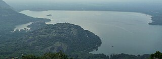
Aliyar ( Reservoir is a 6.48 km2 reservoir located in Aliyar village near Pollachi town in Coimbatore District, Tamil Nadu, South India. The dam is located in the foothills of Valparai, in the Anaimalai Hills of the Western Ghats. It is about 65 kilometres from Coimbatore. The dam offers some ideal getaways including a park, garden, aquarium, play area and a mini Theme-Park maintained by Tamil Nadu Fisheries Corporation for visitors enjoyment. The scenery is beautiful, with mountains surrounding three quarters of the reservoir. Boating is also available.

Gifford Woods State Park is a state park located at the base of Pico Peak in Killington, Vermont. The wooded park provides camping, picnic, and fishing facilities, and has hiking trails, including a portion of the Appalachian Trail. It preserves an area of old-growth forest that has been designated a National Natural Landmark, and is accessible via an interpretive trail. The park was established in 1931. Part of it is listed on the National Register of Historic Places, for facilities developed by the Civilian Conservation Corps in the 1930s.

Malankara dam is a gravity dam constructed across Thodupuzha river for irrigation purposes. The dam is constructed to make use of the tail water from the Moolamattom power house. The project is run under the Muvattupuzha Valley Irrigation Project and KSEB. The artificial lake covers an area of around 11 square km.

Moore Dam is a major hydroelectric dam on the Upper Connecticut River between Grafton County, New Hampshire and Caledonia County, Vermont in the northeastern United States. The dam is located near Littleton, New Hampshire, and forms the 3,490-acre (1,410 ha) Moore Reservoir. The Moore Station is the largest conventional hydroelectric plant in New England, in terms of installed capacity and average power generation. The dam and reservoir also provide flood control, recreational boating and fishing.
Woodford State Park is a 398-acre state park surrounding Adams Reservoir in Woodford, Vermont. The park is at an elevation of 2400 feet in the Green Mountain National Forest. It is located along the Molly Stark Byway. It was designated a state park in 1963.
Waterbury Center State Park is a 90-acre day-use state park on the 850-acre Waterbury Reservoir in Waterbury Center, Vermont. It is located in Mount Mansfield State Forest. It was created in 1986.
Little River State Park is a campground state park on the 850-acre Waterbury Reservoir in Waterbury, Vermont. It is located in Mount Mansfield State Forest.

Camp Plymouth State Park is a 295-acre state park on 96-acre Echo Lake in Ludlow, Vermont.

Mount Mansfield State Forest covers 44,444 acres (179.86 km2) in seven towns in Chittenden, Lamoille and Washington counties in Vermont. The towns are Bolton and Underhill in Chittenden County, Cambridge, Johnson, Morristown and Stowe in Lamoille County, and Waterbury in Washington County. Mt. Mansfield State Forest is the largest contiguous landholding owned by the Vermont Department of Forests, Parks and Recreation.

Molly's Falls Pond State Park is a 1,064-acre state park in Cabot and Marshfield, Vermont surrounding 411-acre Molly's Falls Pond, a reservoir that is also known as Marshfield Reservoir. This is an undeveloped, day-use park. There is a Vermont Fish and Wildlife access area at the northwest end of the park with a concrete boat ramp and two fishing platforms for shore fishing.
