
The Long Trail is a hiking trail located in Vermont, running the length of the state. It is the oldest long-distance trail in the United States, constructed between 1910 and 1930 by the Green Mountain Club. The club remains the primary organization responsible for the trail, and is recognized by the state legislature as "the founder, sponsor, defender, and protector" of the Long Trail System.

The White Mountain National Forest (WMNF) is a federally managed forest contained within the White Mountains in the northeastern United States. It was established in 1918 as a result of the Weeks Act of 1911; federal acquisition of land had already begun in 1914. It has a total area of 750,852 acres (303,859 ha). Most of the WMNF is in New Hampshire; a small part is in the neighboring state of Maine. While often casually referred to as a park, this is a National Forest, used not only for hiking, camping, and skiing but for logging and other limited commercial purposes. The WMNF is the only National Forest located in either New Hampshire or Maine. Most of the major peaks over 4,000 feet high for peak-bagging in New Hampshire are located in the National Forest. Over 100 miles (160 km) of the Appalachian Trail traverses the White Mountain National Forest. In descending order of land area the forest lies in parts of Grafton, Coos, and Carroll counties in New Hampshire, and Oxford County in Maine.

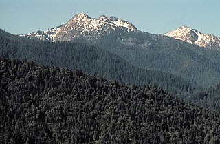
Ashley National Forest is a National Forest located in northeastern Utah and southwestern Wyoming. Within the Forest's bounds are 1,382,346 acres (5,594 km2) of vast forests, lakes, and mountains, with elevations ranging from 6,000 to 13,500 feet. The Forest covers portions of Daggett, Duchesne, Summit, Uintah, and Utah counties in Utah and Sweetwater County in Wyoming. Some of the most popular landmarks located in the Forest include the Flaming Gorge National Recreation Area and the Uinta Mountains, which contains the highest mountain peak in Utah. The Forest also includes 276,175 acres (1,117.64 km2), or about 60.5%, of the High Uintas Wilderness. The headquarters for the Ashley National Forest are located in Vernal, Utah with ranger district offices in Vernal; Duchesne, Utah; Roosevelt, Utah; Manila, Utah; and Green River, Wyoming.

Green Mountain National Forest is a national forest located in Vermont, a temperate broadleaf and mixed forest typical of the New England/Acadian forests ecoregion. The forest supports a variety of wildlife, including beaver, moose, coyote, black bear, white-tailed deer, wild turkey, and ruffed grouse. The forest, being situated in Vermont's Green Mountains, has been referred to as the granite backbone of the state.

The Lye Brook Wilderness is one of eight wilderness areas in the Green Mountain National Forest in the U.S. state of Vermont. It is managed by the U.S. Forest Service. The wilderness area was created by the Eastern Wilderness Areas Act of 1975, which makes it one of the oldest wilderness areas in the state. The area was expanded by both the Vermont Wilderness Act of 1984 and the New England Wilderness Act of 2006.
Rattlesnake National Recreation Area is a United States National Recreation Area located 4 miles north of Missoula, Montana in the Rattlesnake Creek drainage area. It is administered by the Lolo National Forest and is adjacent to the Rattlesnake Wilderness. Both the recreation area and the wilderness area were established by the U.S. Congress on October 19, 1980.
Winding Stair Mountain National Recreation Area is a United States National Recreation Area located within the Ouachita National Forest. State Highway 1, known as the Talimena Scenic Byway in this area, bisects the recreation area. U. S. Highway 271 loops up through the summit. Winding Stair Mountain National Recreation Area and the nearby Upper Kiamichi River and Black Fork Mountain Wilderness areas were created by an act of Congress on October 18, 1988.

Mount Rogers National Recreation Area is a United States National Recreation Area (NRA) located in southwestern Virginia near the border with Tennessee and North Carolina. The centerpiece of the recreation area is the Lewis Fork Wilderness containing Mount Rogers, the highest point in the state of Virginia with a summit elevation of 5,729 feet. The recreation area is under the jurisdiction of the George Washington and Jefferson National Forests. The recreation area was established by an act of the United States Congress on May 31, 1966.
The Red Buttes Wilderness is a wilderness area in the Klamath and Rogue River national forests in the U.S. states of Oregon and California. It comprises 19,940 acres (8,070 ha), approximately 16,190 acres (6,550 ha) of which is located in California, and 3,750 acres (1,520 ha) in Oregon. It was established by the California Wilderness Act of 1984 and the Oregon Wilderness Act of 1984.
The Rogue–Umpqua Divide Wilderness is a wilderness area located in the Rogue River – Siskiyou and Umpqua National Forests in the Klamath Mountains of Oregon, United States. It was established by the United States Congress in 1984 and comprises 33,200 acres (13,400 ha).

The Snow Mountain Wilderness is a 60,076-acre (243.12 km2) federally designated wilderness area located 65 miles (105 km) north of Santa Rosa, California, USA in the Mendocino National Forest. The U.S. Congress passed the California Wilderness Act of 1984 which created 23 new wilderness areas including Snow Mountain. It lies within the North Coast Range of mountains.
The Glastenbury Wilderness is one of eight wilderness areas in the Green Mountain National Forest in the U.S. state of Vermont. The area, located northeast of Bennington, Vermont, is managed by the U.S. Forest Service. With a total of 22,330 acres (9,040 ha), the wilderness is the second largest in Vermont. It was created by the New England Wilderness Act of 2006.

Mount Skokomish Wilderness is a designated wilderness area in the southeast portion of Olympic National Forest on the Olympic Peninsula of Washington in the United States. The wilderness area comprises 13,291 acres (5,379 ha) administered by the U.S. Forest Service.
Moosalamoo National Recreation Area is one of two recreation areas in the Green Mountain National Forest in the U.S. state of Vermont. The recreation area is located between Middlebury and Brandon in the northern half of the Green Mountain National Forest. The area consists of 15,875 acres (6,424 ha) surrounding Mount Moosalamoo.
The Big Branch Wilderness is one of eight wilderness areas in the Green Mountain National Forest in the U.S. state of Vermont. It was created by the Vermont Wilderness Act of 1984 and later expanded by the New England Wilderness Act of 2006. A total of 6,725 acres (2,722 ha) are managed by the U.S. Forest Service.
The Peru Peak Wilderness is one of eight wilderness areas in the Green Mountain National Forest in the U.S. state of Vermont. It was created by the Vermont Wilderness Act of 1984 and later expanded by the New England Wilderness Act of 2006. A total of 7,825 acres (3,167 ha) are managed by the U.S. Forest Service.
The Breadloaf Wilderness is one of eight wilderness areas in the Green Mountain National Forest in the U.S. state of Vermont. It was created by the Vermont Wilderness Act of 1984 and later expanded by the New England Wilderness Act of 2006. With a total of 24,986 acres (10,111 ha), it is the largest wilderness area in Vermont. The area is managed by the U.S. Forest Service.
The Joseph Battell Wilderness is one of eight wilderness areas in the Green Mountain National Forest in the U.S. state of Vermont. The wilderness area, created by the New England Wilderness Act of 2006, is named in honor of Joseph Battell (1839–1915), a philanthropist and environmentalist from Middlebury, Vermont. The wilderness consists of 12,336 acres (4,992 ha) managed by the U.S. Forest Service.

The Vermont Wilderness Act of 1984 was signed into law by President Ronald Reagan on June 19, 1984. The Act designated four (4) new wilderness areas in the U.S. state of Vermont, while expanding one (1) existing wilderness area. A total of 41,260 acres (16,700 ha) of new wilderness were created, all in the Green Mountain National Forest. The Act also created a new recreation area in Vermont.
The New England Wilderness Act of 2006 was signed into law by President George W. Bush on December 1, 2006. The Act designated three (3) new wilderness areas in the U.S. states of New Hampshire and Vermont, while expanding five (5) existing wilderness areas across these two states. A total of 76,152 acres (30,818 ha) of new wilderness were created, in the White Mountain National Forest and the Green Mountain National Forest. The Act also created a new recreation area in Vermont.


