Hardwick is a town in Caledonia County, Vermont, United States. The population was 2,920 at the 2020 census. It contains the unincorporated villages of Hardwick, East Hardwick, and Mackville. The town is a commercial center for the region's farming population.

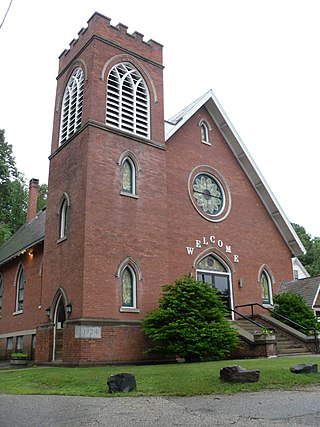
The Christian Union Society Meetinghouse, more recently known as the South Walden United Methodist Church, is a historic church on Bayley-Hazen Military Road in South Walden, Vermont. Built in 1825, it is a prominent local example of Federal style architecture. It is also notable for its association with a 19th-century religious movement in the region known as the "Age of Benevolence". The building was listed on the National Register of Historic Places in 1980.

West Dover is a village in the central part of Dover, Vermont. The village center, located on Vermont Route 100 at Cross Town and Valley View Roads, was listed on the National Register of Historic Places in 1985 as the West Dover Historic District. The village is a major service point for the nearby Mount Snow ski area. The ZIP Code for West Dover is 05356

The Brattleboro Downtown Historic District encompasses most of the central business district of the town of Brattleboro, Vermont. Extending along Main Street between Whetstone Brook and a junction with Pultney Road and Linden and Walnut Streets, this area includes many of the town's prominent civic and institutional buildings. The area's development took place primarily in the 19th century, with surviving buildings from both the 18th and early 20th centuries. The district was listed on the National Register of Historic Places in 1983, and was enlarged in 2004 to include Plaza Park and the Holstein Building on the south side of Whetstone Brook.

The Danby Village Historic District encompasses much of the town center of Danby, Vermont. It is centered on a stretch of Main Street, roughly between Depot Street and Brook Road. The village has a cohesive collection of mid-19th century architecture, mostly residential, with a modest number of later additions. The district was listed on the National Register of Historic Places in 1983.

The Chester Village Historic District encompasses the historic southern portion of the main village of Chester, Vermont, US. Essentially a linear stretch of Main Street, this area includes some of the village's oldest buildings and has an architectural history spanning into the early 20th century. The district was listed on the National Register of Historic Places in 1985.
The Christian Street Rural Historic District encompasses the surviving elements of an early settlement village in the town of Hartford, Vermont. Centered on the junction of Christian Street and Jericho Street in northeastern Hartford, the area includes a modest number of 18th and 19th-century houses, as well as two farms that have been in the same families since the 18th century. The district was listed on the National Register of Historic Places in 2003.
The Jericho Rural Historic District encompasses a rural agricultural landscape of northern Hartford, Vermont, extending slightly into neighboring Norwich. The area covers 774 acres (313 ha) of mainly agricultural and formerly agricultural lands, as well as associated woodlots, and includes nine historically significant farm complexes. It was listed on the National Register of Historic Places in 2001.

The Bayley Historic District encompasses a small cluster of buildings in Newbury, Vermont, a number of which are associated with the historically prominent Bayley family. It includes some of the town's oldest buildings, and is where the founder of the town, Jacob Bayley, first settled and later died. The district is oriented along Oxbow Road west of United States Route 5 and north of the town's main village. It was listed on the National Register of Historic Places in 1983.

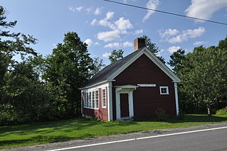
The Spencer Hollow School is a historic school building at 50 Spencer Hollow Road in Springfield, Vermont. Built about 1810, it is a fine local example of a district schoolhouse. It was used as a school until 1926, and as a clubhouse for a time thereafter. It was listed on the National Register of Historic Places in 2012.
The Springfield Downtown Historic District encompasses the historic central business district of the town of Springfield, Vermont. Located in a narrow valley on the banks of the Black River, the town's architecture is primarily reflective of its importance as a manufacturing center in the late 19th and early-to-mid 20th centuries, with a cluster of commercial buildings surrounded by residential and industrial areas. It was listed on the National Register of Historic Places in 1983, and enlarged slightly in 1986.
The Charlotte Center Historic District encompasses the historic 19th-century town center of Charlotte, Vermont. Settled c. 1790 and developed mainly in the mid-19th century, the village, stretched along Church Hill Road west of Hinesburg Road, retains a well-preserved 19th-century atmosphere of residential, civic, and commercial buildings. The district was listed on the National Register of Historic Places in 1984.
The Jericho Village Historic District encompasses the historic industrial and commercial center of the village of Jericho, Vermont. Stretched along Vermont Route 15 south of Browns River, which powered the village's industries for many years, the village center includes a well-preserved array of 19th and early 20th-century buildings. The district was listed on the National Register of Historic Places in 1992.

The Montgomery House is a historic travel accommodation on Vermont Route 118 in the center of Montgomery, Vermont. Built in 1803, it is one of the town's oldest buildings, and it served for many years as a social and civic center in the small community. It was listed on the National Register of Historic Places in 1992.

The Warren Village Historic District encompasses the village center of Warren, Vermont, United States. Stretched mainly along Main Street east of the Mad River, it is a well-preserved 19th-century mill village, although most of its period mill infrastructure has been lost. The district has good examples of Greek Revival, Italianate, and Second Empire architecture. It was listed on the National Register of Historic Places in 1992.

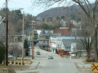
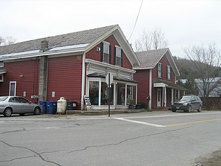
The Downtown Hardwick Village Historic District encompasses a significant portion of the downtown area of Hardwick, Vermont. The town developed in the 19th century first as a small industrial center, and later became one of the world's leading processors of granite. The district was listed on the National Register of Historic Places in 1982.

The Elkins Tavern is a historic house on Bayley-Hazen Road in Peacham, Vermont. Built in 1787 by one of Peacham's first settlers, it has one of the best-preserved 18th-century interiors in the state of Vermont. It was listed on the National Register of Historic Places in 1978.

The Peacham Corner Historic District encompasses much of the historic village center of Peacham, Vermont. The village's period of greatest growth and importance between the town's founding as a hill town in the late 18th century, and 1860, when significant development effectively ended. As a result, the village lacks Victorian features often found in other rural communities. The district was listed on the National Register of Historic Places in 2003.

The Josiah and Lydia Shedd Farmstead is a historic farm property at 1721 Bayley-Hazen Road in Peacham, Vermont. Established in 1816, the property evokes a typical 19th-century Vermont hill farm. Its oldest surviving buildings, the main house and two barns, survive from the second quarter of the 19th century. The property was listed on the National Register of Historic Places in 2005.
East Hardwick is an unincorporated village in the town of Hardwick, Vermont, United States. It is part of what is known as the Northeast Kingdom (NEK) of Vermont. The community is located on the Lamoille River and along Vermont Route 16, 16 miles (26 km) west-northwest of St. Johnsbury. East Hardwick has a post office with ZIP code 05836, which opened on October 10, 1810. According to a 1937 WPA Federal Writers Project Guidebook, East Hardwick is a "side hill village spilling from the level of a plateau down a sharp incline in the valley of the Lamoille. It is surrounded by rich farm lands, Maple groves and forests."


