
Carn Euny is an archaeological site near Sancreed, on the Penwith peninsula in Cornwall, United Kingdom with considerable evidence of both Iron Age and post-Iron Age settlement. Excavations on this site have shown that there was activity at Carn Euny as early as the Neolithic period. There is evidence that shows that the first timber huts there were built about 200 BC, but by the 1st century BC, these had been replaced by stone huts. The remains of these stone huts are still visible today.
Entrance grave is a type of Neolithic and early Bronze Age chamber tomb found primarily in Great Britain. The burial monument typically consisted of a circular mound bordered by a stone curb, erected over a rectangular burial chamber and accessed by a narrow, stone lined entrance. Entrance graves have been discovered in the Isles of Scilly, west Cornwall, southeast Ireland, southwest Scotland, Brittany and the Channel Islands. They are often referred to as the Scillonian' Group, named for the Scillian Islands where the majority of entrance graves have been discovered.
Porth Hellick Down is a Neolithic and Bronze Age archeological site located on the island of St Mary's, in the Isles of Scilly in Great Britain. The ancient burial monument encompasses a large cairn cemetery that includes at least six entrance graves, other unchambered cairns, and a prehistoric field system. The site is notable for having the largest assembly of surviving entrance graves.
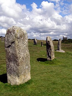
The Hurlers is a group of three stone circles in the civil parish of St Cleer, Cornwall, England, UK. The site is half-a-mile (0.8 km) west of the village of Minions on the eastern flank of Bodmin Moor, and approximately four miles (6 km) north of Liskeard at grid reference SX 258 714.
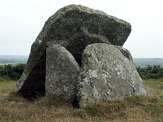
Chûn Quoit is one of the best preserved of all Neolithic quoits in western Cornwall, United Kingdom.

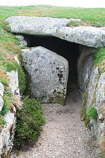
The Tregiffian Burial Chamber is a Neolithic or early Bronze Age chambered tomb. It is near Lamorna in west Cornwall, United Kingdom. It is a rare form of a passage grave, known as an Entrance grave. It has an entrance passage, lined with stone slabs, which leads into a central chamber. This type of tomb is also found in the neighbouring Isles of Scilly.
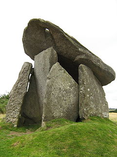
Trethevy Quoit is a well-preserved megalithic structure between St Cleer and Darite in Cornwall, United Kingdom. It is known locally as "the giant's house". Standing 9 feet (2.7 m) high, it consists of five standing stones capped by a large slab and was added to the Heritage At Risk register in 2017.

Chapel Carn Brea is an elevated Hercynian granite outcrop, owned by the National Trust at the southern edge of the civil parish of St Just, Cornwall, England, United Kingdom. The hill is 5 kilometres (3.1 mi) south of St Just and 3.5 kilometres (2.2 mi) east of Sennen Cove, and just to the north of the A30 London to Land's End road, which runs through the village of Crows-an-Wra. It should not be confused with another Carn Brea, the hill overlooking the Camborne–Redruth area.

The dolmens of Jersey are neolithic sites, including dolmens, in Jersey. They range over a wide period, from around 4800 BC to 2250 BC, these dates covering the periods roughly designated as Neolithic, or “new stone age”, to Chalcolithic, or “copper age”.

The Tumulus of Bougon or Necropolis of Bougon is a group of five Neolithic barrows located in Bougon near La-Mothe-Saint-Héray, between Exoudon and Pamproux in Nouvelle-Aquitaine, France. Their discovery in 1840 raised great scientific interest. To protect the monuments, the site was acquired by the department of Deux-Sèvres in 1873. Excavations resumed in the late 1960s. The oldest structures of this prehistoric monument date to 4800 BC.
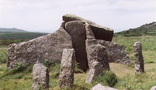
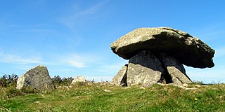
Zennor Quoit is a ruined megalithic burial chamber or dolmen, located on a moor about a mile (1.6 km) east of the village of Zennor, Cornwall, England, UK. It dates to 2500–1500 BC. Aside from the 12.5-tonne (12,500 kg) roof, which collapsed some time between 1770 and 1865, the chamber is in good condition.

Obadiah's Barrow or Obadiah's Grave is a Neolithic entrance grave located on the island of Gugh in the Isles of Scilly. The grave sits on a steep slope on the southwestern side of Kittern Hill, the highest point on Gugh. The grave was excavated in 1901 by British archaeologist, George Bonsor.

Nordic megalith architecture is an ancient architectural style found in Northern Europe, especially Scandinavia and North Germany, that involves large slabs of stone arranged to form a structure. It emerged in northern Europe, predominantly between 3500 and 2800 BC. It was primarily a product of the Funnelbeaker culture. Between 1964 and 1974, Ewald Schuldt in Mecklenburg-Western Pomerania excavated over 100 sites of different types: simple dolmens, extended dolmens, passage graves, great dolmens, unchambered long barrows, and stone cists. In addition, there are polygonal dolmens and types that emerged later, for example, the Grabkiste and Röse. This nomenclature, which specifically derives from the German, is not used in Scandinavia where these sites are categorised by other, more general, terms, as dolmens, passage graves and stone cists.
Mulfra Quoit is a Neolithic dolmen in the county of Cornwall in England. It stands on Mulfra Hill to the north of the hamlet of Mulfra.

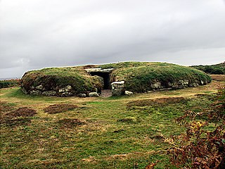
Innisidgen is the site of two Bronze Age entrance graves on the island of St Mary's in the Isles of Scilly. The two burial monuments, lie on a steep slope of Innisidgen Hill overlooking Crow Sound with a view towards the Eastern Isles.

The Grey Mare and her Colts is a megalithic chambered long barrow located near Abbotsbury in Dorset, England. It was built during the Early and Middle Neolithic periods. The tomb was partially excavated in the early nineteenth century, and was found to contain human bones and several pottery fragments.

Din Dryfol is a Neolithic burial chamber on Anglesey, in Wales. It is a scheduled monument and is maintained by Cadw. The monument is near Bethel. Three phases of use have been identified, all dating from the Neolithic period.

Pawton Quoit is a prehistoric portal dolmen, which dates to the Early and Middle Neolithic period in England. The burial monument is located near Haycrock Farm, south of St Breock, in Cornwall, England.

Trefignath is a Neolithic burial chamber near Trearddur, south of Holyhead on Holy Island, off Anglesey in Wales. In its most complete form it included a large cairn covering three stone tombs, set on a small knoll. It was excavated between 1977 and 1979, revealing several phases of occupation with three separate burial chambers built in succession. It is a scheduled ancient monument, maintained by Cadw.


