Vojvodina, officially the Autonomous Province of Vojvodina, is an autonomous province of Serbia, located in the northern part of the country, in the Pannonian Plain.

The Banat is a geographical and historical region in Central Europe that is currently divided among three countries: the eastern part lies in western Romania ; the western part in northeastern Serbia ; and a small northern part lies within southeastern Hungary.

Požarevac is a city and the administrative center of the Braničevo District in eastern Serbia. It is located between three rivers: Danube, Great Morava and Mlava. As of 2011, the city has a population of 44,183 inhabitants, while the city administrative area has 75,334 inhabitants.

Smederevo is a city and the administrative center of the Podunavlje District in eastern Serbia. It is situated on the right bank of the Danube, about 45 kilometres downstream of the Serbian capital, Belgrade.
The Middle Ages in Albania geographically refers to the region that is now Albania in the Byzantine Empire, until their incorporation in the Ottoman Empire.
Syrmia is a fertile region of the Pannonian Plain in Europe, which lies between the Danube and Sava rivers. The majority of Syrmia is located in the Srem and South Bačka districts of the Autonomous Province of Vojvodina in Serbia. A smaller area around Novi Beograd, Zemun, and Surčin belongs to the City of Belgrade. The remaining part of Syrmia is divided between multiple municipalities in Serbia and Vukovar-Srijem County in Croatia.

The foundation and rise of the Ottoman Empire is a period of history that started with the emergence of the Ottoman principality in c. 1299, and ended with the conquest of Constantinople on May 29, 1453. This period witnessed the foundation of a political entity ruled by the Ottoman Dynasty in the northwestern Anatolian region of Bithynia, and its transformation from a small principality on the Byzantine frontier into an empire spanning the Balkans and Anatolia. For this reason, this period in the empire's history has been described as the Proto-Imperial Era. Throughout most of this period, the Ottomans were merely one of many competing states in the region, and relied upon the support of local warlords and vassals to maintain control over their realm. By the middle of the fifteenth century the Ottoman sultans were able to accumulate enough personal power and authority to establish a centralized imperial state, a process which was brought to fruition by Sultan Mehmed II. The conquest of Constantinople in 1453 is seen as the symbolic moment when the emerging Ottoman state shifted from a mere principality into an empire, marking a major turning point in its history.

Mačva is a geographical and historical region in the northwest of Central Serbia, on a fertile plain between the Sava and Drina rivers. The chief town is Šabac. The modern Mačva District of Serbia is named after the region, although the region of Mačva includes only the northern part of this district. A small northern part of Mačva region is in the Autonomous Province of Vojvodina, in the Syrmia District.
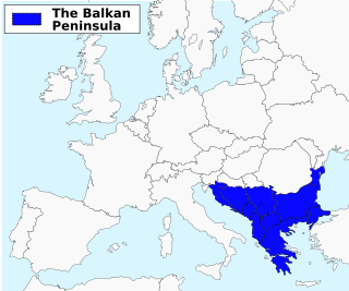
The Balkans is an area situated in Southeastern and Eastern Europe. The distinct identity and fragmentation of the Balkans owes much to its common and often violent history regarding centuries of Ottoman conquest and to its very mountainous geography.
Podunavlje is the name of the Danube river basin parts located in Serbia and Croatia. Podunavlje is located on the southern edge of Pannonian Basin. In its wider meaning, the term is used in Serbian and Croatian as a description for the area around the entire flow of the river Danube.
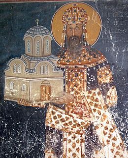
Stefan Uroš II Milutin, known as Stefan Milutin, was the King of Serbia between 1282–1321, a member of the Nemanjić dynasty. He was one of the most powerful rulers of Serbia in the Middle Ages. Milutin is credited with strongly resisting the efforts of Byzantine Emperor Michael VIII Palaiologos to impose Roman Catholicism on the Balkans after the Union of Lyons in 1274. As most of the Nemanjić monarchs, he was proclaimed a saint by the Serbian Orthodox Church with a feast day on October 30.

Strumica is the largest city in eastern Republic of North Macedonia, near the Novo Selo-Petrich border crossing with Bulgaria. About 100,000 people live in the region surrounding the city. It is named after the Strumica River which runs through it. The city of Strumica is the seat of Strumica Municipality.
Vojvodina is the Serbian name for the territory in Northern Serbia, consisting of the southern part of the Pannonian Plain, mostly located north from the Danube and Sava rivers.
The South Slavs are a subgroup of Slavic peoples who speak the South Slavic languages. They inhabit a contiguous region in the Balkan Peninsula and the eastern Alps, and in the modern era are geographically separated from the body of West Slavic and East Slavic people by the Romanians, Hungarians, and Austrians in between. The South Slavs today include the nations of Bosniaks, Bulgarians, Croats, Macedonians, Montenegrins, Serbs and Slovenes. They are the main population of the Eastern and Southeastern European countries of Bosnia and Herzegovina, Bulgaria, Croatia, Montenegro, North Macedonia, Serbia and Slovenia.

This is the history of Bosnia and Herzegovina in the Middle Ages, between the ancient and Roman period and the Ottoman period.
Myzeqe or Myzeqeja is a plain in the southwestern-central Albania, sometimes referred to as being between the Shkumbin and Seman rivers, and sometimes extending south to the Vjose river north of Vlorë. Administratively, the region falls mainly within Lushnjë and Fier District. Other terms like Myzeqeja e Vogël, Myzeqeja e Beratit, or Myzeqeja e Vlorës are used to point respectively to the Fier part of the region, and to tiny parts that fall into the adjacent districts of Berat and Vlorë. It stretches 65 km north-south and 50 km east-west, with a total area of around 1350 square kilometers.
The Bulgarian–Hungarian wars were a series of conflicts that occurred during the 9th–14th centuries between the Bulgarian Empire and the Kingdom of Hungary. The nearly 500-year conflict encompassed the northern and western Balkans, or what is known today as north-western Serbia, Romania and northern Bulgaria.

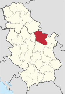
Darman and Kudelin (Куделин) were two Bulgarian nobles who jointly ruled the region of Braničevo as independent or semi-independent autocrats in the late 13th century (1273–1291). Regarded by historians to be "probably Bulgarians of Cuman origin", the two brothers used the weakened state of centralized administration in the region to become independent from the Second Bulgarian Empire or the Kingdom of Hungary in 1273. The capital of their domains was the fortress of Zhdrelo, on the Mlava river. Relying on their army that consisted of people of various ethnicities, but mostly Bulgarians, Tatars and Cumans, the brothers were "very independent-minded and afraid of no one".
Shishman was a Bulgarian nobleman (boyar) who ruled a semi-independent realm based out of the Danubian fortress of Vidin in the late 13th and early 14th century. Shishman, who was bestowed the title of "despot" by Bulgarian emperor George Terter I, was a Cuman, and may have been established as lord of Vidin as early as the 1270s.