Broomhouse railway station

Last updated

Broomhouse
Broomhouse Station (remains) - geograph.org.uk - 1923669.jpg
General information
Location Broomhouse, Glasgow
Scotland
Coordinates 55°50′25″N4°07′16″W / 55.840260°N 4.121096°W / 55.840260; -4.121096 Coordinates: 55°50′25″N4°07′16″W / 55.840260°N 4.121096°W / 55.840260; -4.121096
Platforms2
Other information
StatusDisused
History
Original company North British Railway
Post-grouping LNER
Key dates
1878Opened as Broomhouse [1]
1 January 1917Closed [1]
2 June 1919Re-opened
24 September 1927Closed to passengers [1] [2]
1 September 1953Station closed to freight
4 October 1964Line closed to freight

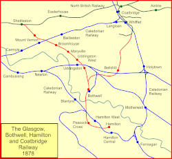
Broomhouse railway station [1] [2] was opened in 1878 at Broomhouse in the Baillieston area of Glasgow, Scotland on the old Glasgow, Bothwell, Hamilton and Coatbridge Railway between Shettleston and Hamilton. The miner's rows at Boghall were close to the station site.

Contents

History

Map of the GBH&CR before the halt was opened. GBH&CR.gif
Map of the GBH&CR before the halt was opened.

The station was opened by the North British Railway to serve the Broomhouse area in 1878 [1] on the Glasgow, Bothwell, Hamilton and Coatbridge Railway route.

The route was also known as the London and North Eastern Railway's Hamilton Branch. It closed to passenger traffic on 4 October 1927 and to freight in 1953, having been previously closed to passengers between 1917 and 1919 as a wartime economy. [1] The line was closed to freight traffic on 4 October 1964. Passenger trains continued to run to Bothwell until 4 July 1955. [3]

Infrastructure

A signal box that controlled the colliery line lay at the south end of the station on the north side, replaced in 1914 and closed in 1960. [4] Daldowie and Broomhouse collieries lay nearby to the north and south respectively, [5] and crossovers on the double-track line in the area of the station allowed for the movement of waggons for these customers. There was a siding to a brickworks. [5] The ticket office and waiting room were on the south platform, and a shelter on the north and a pedestrian footbridge were present. [6] [7]

The line to the west cut over the Caledonian Railway's Rutherglen and Coatbridge Railway line. [7]

Remains on site

A road now runs across the old station site.

Preceding station Disused railways Following station
Calderpark   North British Railway
Glasgow, Bothwell, Hamilton and Coatbridge Railway
  Mount Vernon (NBR)

Related Research Articles

<span class="mw-page-title-main">Whifflet railway station</span> Railway station in North Lanarkshire, Scotland

Whifflet railway station is located in the Whifflet area of Coatbridge. Train services are provided by ScotRail. Until December 2014, it was the terminal station on the Whifflet Line, since when it is served by Argyle Line services.

<span class="mw-page-title-main">Bellshill railway station</span> Railway station in North Lanarkshire, Scotland

Bellshill railway station is a railway station in the town of Bellshill, North Lanarkshire, Scotland. The station is managed by ScotRail and served by Argyle Line and Shotts Line services. The station is adjacent to Bellshill Main Street, on Hamilton Road, and was opened by the Caledonian Railway as part of the Cleland and Midcalder Line on 1 May 1879. West of the station, the Glasgow, Bothwell, Hamilton and Coatbridge Railway crossed with a second station in the town to the north west - this ceased to carry passengers back in 1951.

<span class="mw-page-title-main">Carmyle railway station</span> Railway station in Glasgow, Scotland

Carmyle railway station is located in the Carmyle area of Glasgow. It is on the Whifflet Line, 5.5 miles (8.9 km) east of Glasgow Central railway station. Train services are provided by ScotRail Trains.

<span class="mw-page-title-main">Baillieston railway station</span> Railway station in Glasgow, Scotland

Baillieston railway station is located in Caledonia Road on the southern boundary of the Baillieston area of Glasgow, Scotland, with the Broomhouse area on the other side of the tracks. It is on the Whifflet Line, 8 miles (13 km) east of Glasgow Central railway station. Train services are provided by ScotRail.

<span class="mw-page-title-main">Coatbridge Central railway station</span> Railway station in North Lanarkshire, Scotland

Coatbridge Central railway station is a station in Coatbridge, North Lanarkshire, Scotland. It is on the Argyle Line. Train services are provided by ScotRail.

<span class="mw-page-title-main">Wishaw railway station</span> Railway station in North Lanarkshire, Scotland, UK

Wishaw railway station is a railway station in Wishaw, North Lanarkshire, Scotland. The station is managed by ScotRail and lies on the Wishaw Deviation Line just south of the single track link line which connects to the West Coast Main Line at Shieldmuir.

<span class="mw-page-title-main">Shettleston railway station</span> Railway station in Glasgow, Scotland

Shettleston railway station serves the Shettleston area of Glasgow, Scotland and is 3½ miles (5 km) east of Glasgow Queen Street railway station on the North Clyde Line. The station is managed by ScotRail.

The Bathgate and Coatbridge Railway, also known as the "New Monkland Line", was built by Monkland Railways. It opened on 28 July 1863. The line was absorbed into the Edinburgh and Glasgow Railway on 31 July 1865. The following day, the line became part of the North British Railway.

The Rutherglen and Coatbridge Railway was a railway line in Scotland built by the Caledonian Railway to shorten the route from the Coatbridge area to Glasgow. It opened in 1865. It was later extended to Airdrie in 1886, competing with the rival North British Railway. Soon after a further extension was built from Airdrie to Calderbank and Newhouse.

<span class="mw-page-title-main">Coatbridge Branch (NBR)</span>

The Coatbridge Branch of the North British Railway was a railway built to connect the important coal and iron industrial districts of Coatbridge and Airdrie directly to Glasgow for the North British Railway.

<span class="mw-page-title-main">Bathgate Upper railway station</span> Disused railway station in Bathgate, West Lothian

Bathgate Upper railway station was a railway station serving the town of Bathgate in West Lothian, Scotland. It was located on the Bathgate and Coatbridge Railway.

<span class="mw-page-title-main">Burnbank railway station</span> Disused railway station in Scotland

Burnbank railway station was a railway station that served the suburb of Burnbank in Hamilton, South Lanarkshire. It is one of several railway stations to have served Hamilton, and one of three to be closed permanently.

Mount Vernon railway station served the Mount Vernon area of Glasgow, Scotland on the Glasgow, Bothwell, Hamilton and Coatbridge Railway between Shettleston and Hamilton.

Uddingston East railway station served the town of Uddingston in South Lanarkshire on the Glasgow, Bothwell, Hamilton and Coatbridge Railway between Shettleston and Hamilton.

Uddingston West railway station served the town of Uddingston in South Lanarkshire on the Glasgow, Bothwell, Hamilton and Coatbridge Railway between Shettleston and Hamilton.

The Glasgow, Bothwell, Hamilton and Coatbridge Railway was a railway company in Scotland, built to serve coal and ironstone pits in the Hamilton and Bothwell areas, and convey the mineral to Glasgow and to ironworks in the Coatbridge area. It was allied to the North British Railway, and it opened in 1877. Passenger services followed.

The Caledonian Railway branches in North Lanarkshire built on the Caledonian Railway main line, which opened in 1848. In the following years the considerable increase of iron production and coal extraction in North Lanarkshire led to a progressive expansion of branch lines in the area between the eastern margin of Glasgow and Bellside in the east, and between Coatbridge, Airdrie and Motherwell. Mineral traffic was dominant and for some years passenger operation followed the construction of some of the mineral connections. In 1861 the Rutherglen and Coatbridge line was opened, extended later to Airdrie, rivalling the established Monkland Railways route. In 1869 the connection from Cleland to Midcalder was opened, connecting mineral sites but also forming a new passenger route to Edinburgh.

Calderpark Halt railway station or Calderpark for Glasgow Zoo (NS679625) served Calderpark Zoo opened in 1947 on the old estate of Calderpark and the Baillieston area of Glasgow, Scotland on the Glasgow, Bothwell, Hamilton and Coatbridge Railway between Shettleston and Hamilton. Glasgow Zoo closed in 2003.

Maryville railway station (NS687620) was opened in 1878 at Maryville, a small community in the Uddingston area to the south-east of Glasgow, Scotland on the old Glasgow, Bothwell, Hamilton and Coatbridge Railway between Shettleston and Hamilton. Clydeside and Bredisholm collieries were also served by the station.

<span class="mw-page-title-main">Bothwell railway station</span> Disused railway station in Bothwell, South Lanarkshire

Bothwell railway station served the village of Bothwell, South Lanarkshire, Scotland from 1878 to 1955 on the Glasgow, Bothwell, Hamilton and Coatbridge Railway.

References

Notes

  1. 1 2 3 4 5 6 Butt (1995), page 46
  2. 1 2 Wignal (1983), Page 10
  3. "Broomhouse Station (remains) © Ben Brooksbank :: Geograph Britain and Ireland". Geograph. Retrieved 8 July 2022.
  4. NS66SE - A (includes: Blantyre; Bothwell; Cambuslang; Glasgow; Old Monkland) Surveyed / Revised:1930 to 1957. Published:1958
  5. 1 2 Broomhouse Community Council
  6. Lanarkshire Sheet VII.SW (includes: Glasgow; Old Monkland) Publication date:1899. Date revised: 1897.
  7. 1 2 Lanarkshire VII.14 (Bothwell; Glasgow; Old Monkland) Publication date:1913. Revised:1910. Levelled:1910

Sources