Bruzzano

Last updated

Bruzzano
Quartier of Milan

Milano - chiesa Beata Vergine Assunta in Bruzzano - facciata.jpg

Church of Santa Maria Assunta
CountryFlag of Italy.svg  Italy
Region Lombardy
Province Milan
Comune Milan
Zone 9
Time zone CET (UTC+1)
  Summer (DST) CEST (UTC+2)

Bruzzano is a district (quartier) of Milan, Italy. It is an area located within Zone 9 of the city.

Milan Italian city

Milan is a city in northern Italy, capital of Lombardy, and the second-most populous city in Italy after Rome, with the city proper having a population of 1,372,810 while its metropolitan area has a population of 3,244,365. Its continuously built-up urban area has a population estimated to be about 5,270,000 over 1,891 square kilometres. The wider Milan metropolitan area, known as Greater Milan, is a polycentric metropolitan region that extends over central Lombardy and eastern Piedmont and which counts an estimated total population of 7.5 million, making it by far the largest metropolitan area in Italy and the 54th largest in the world. Milan served as capital of the Western Roman Empire from 286 to 402 and the Duchy of Milan during the medieval period and early modern age.

Italy republic in Southern Europe

Italy, officially the Italian Republic, is a country in Southern and Western Europe. Located in the middle of the Mediterranean Sea, Italy shares open land borders with France, Switzerland, Austria, Slovenia and the enclaved microstates San Marino and Vatican City. Italy covers an area of 301,340 km2 (116,350 sq mi) and has a largely temperate seasonal and Mediterranean climate. With around 61 million inhabitants, it is the fourth-most populous EU member state and the most populous country in Southern Europe.

Overview

Its name comes from the Latin Bruttianum, as the land owner of the agricultural fundus was a Roman citizen coming from Bruttium [1] (today Calabria). In this region, in fact, there is now the namesake municipality of Bruzzano Zeffirio. The first written documents that testify the existence of an independent comune dates back to 1346, [2] while the earliest proof of the existence of the church of Santa Maria Assunta dates back to 1011. [3]

Calabria Region of Italy

Calabria, known in antiquity as Bruttium, is a region in Southern Italy.

Bruzzano Zeffirio Comune in Calabria, Italy

Bruzzano Zeffirio is a comune (municipality) in the Province of Reggio Calabria in the Italian region Calabria, located about 110 kilometres (68 mi) southwest of Catanzaro and about 40 kilometres (25 mi) southeast of Reggio Calabria.

Bruzzano formed a separate municipality until 1869, when it joined Affori, Bresso and Dergano to form the Comune di Affori e Uniti (named again just Affori since 1912), which was then annexed in Milan in 1923.

Affori Former commune annexed by Milan in 1923 in Lombardy, Italy

Affori is a ward of Milan, Italy, part of the Zone 9 administrative division of the city, located north of the city centre. It borders with the wards of Bruzzano, Comasina, Bovisasca, Dergano and Niguarda. Before being annexed to Milan in 1923, it was an autonomous comune.

Bresso Comune in Lombardy, Italy

Bresso is a comune (municipality) in the Metropolitan City of Milan in the Italian region Lombardy, located about 8 kilometres (5 mi) north of Milan. At the 2001 census the municipality had a population of 26,255 inhabitants and a population density of 8,027.2 persons/km², making it the most densely populated comune in Italy outside the Province of Naples.

Dergano is a district of Milan, Italy. It is an area located within Zone 9 of the city.

Related Research Articles

Campione dItalia Comune in Lombardy, Italy

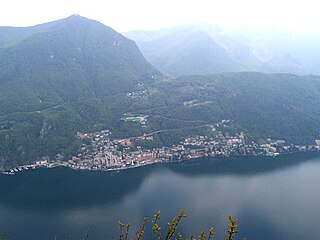
Campione d'Italia is a comune of the Province of Como in the Lombardy region of Italy and an exclave surrounded by the Swiss canton of Ticino. At its closest, the exclave is less than one kilometre (0.6 mi) from the rest of Italy, but the intervening mountainous terrain requires a journey by road of over 14 km (9 mi) to reach the nearest Italian town, Lanzo d'Intelvi, and over 28 km (17 mi) to reach the city of Como.

Province of Monza and Brianza Province of Italy

The Province of Monza and Brianza,, is an administrative province of Lombardy region, Italy.

San Siro, Como Comune in Lombardy, Italy

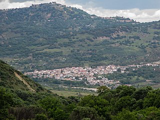
San Siro is a comune (municipality) in the Province of Como in the Italian region Lombardy, located on the northwest shore of Lake Como immediately north of Menaggio and south of Cremia.

Zeme, Lombardy Comune in Lombardy, Italy

Zeme is a village and comune in the Province of Pavia, in the Lombardy region of northwest Italy.

Vaiano Valle is a rural district ("quartiere") of Milan, Italy, part of the Zone 5 administrative division. It is located south of the city's urban area, within the Parco Agricolo Sud Milano nature reserve. Before 1869, it was an autonomous comune.

Chiaravalle (district of Milan) Quartiere of Milan in Lombardy, Italy

Chiaravalle is a district (quartiere) of Milan, Italy, part of the Zone 5 administrative division of the city. It is located in the periphery south of the city centre, within the Parco Agricolo Sud Milano nature reserve.

Quintosole is a district ("quartiere") of Milan, Italy, part of the Zone 5 administrative division. It is a rural district, located within the Parco Agricolo Sud Milano nature reserve, south of Milan's urban area. Before 1869, it was an autonomous comune.

Figino is a district ("quartiere") of Milan, Italy, part of the Zone 7 administrative division. It is located north-west of the centre, within the Parco Agricolo Sud Milano nature reserve. Before being annexed to Milan, in 1869, it was an autonomous comune, named Figino di Milano.

Baggio (district of Milan) Quartiere of Milan in Lombardy, Italy

Baggio is a district (quartiere) of Milan, Italy, part of the Zone 7 administrative division of the city. Before being annexed to Milan in 1923, it was an autonomous comune.

Garegnano Quartiere of Milan in Lombardy, Italy

Garegnano is a district ("quartiere") of Milan, Italy, part of the Zone 8 administrative division of the city, north-west of the city centre. Before being annexed to Milan, it has been an autonomous comune, originally known as Garegnano Marcido.

Vialba is a district ("quartiere") of Milan, Italy, part of the Zone 8 administrative division of the city. It is located north of the city centre, adjacent to the municipality (comune) of Novate Milanese. Until 1841, Vialba itself was an autonomous comune.

Zone 9 of Milan Zona of Milan in Lombardy, Italy

The Municipality 9 of Milan is one of the 9 administrative zones of Milan, Italy. It corresponds to the northern area of the city.

Musocco is a suppressed Italian comune, independent from the eighteenth century to 1808 and from 1815 until 1923, when the town was incorporated in Milan.

Milan–Asso railway railway line

The Milan–Asso railway is a regional railway line with standard track gauge which links Milan to Canzo crossing for Erba and other towns in Brianza. The most northern terminal is the station of Canzo-Asso, which is located in Canzo's territory but is commonly known as Asso in the short form. That, because there is another station on the line called Canzo station and Canzo-Asso is next to Asso's boundary and serves this commune too.

The Villa Litta Modignani is a 17th-century rural palace and park located on Via Taccioli in the north suburbs of Milan, in the Province of Milan, Lombardy, Italy.

Saint Ambrose, Brugherio religious building in Brugherio

Saint Ambrose is a small church which is an annex to the farmhouse that takes its name from it, in Brugherio, Italy.

Cassina Baraggia Place in Lombardy, Italy

Cassina Baraggia is a hamlet of Brugherio's municipality, which until 1866 was a separate municipality.

Mirabello di Pavia human settlement in Italy

Mirabello is a suburb of Pavia, Lombardy, northern Italy. It lies north of the city, bordering San Genesio ed Uniti.

Lardera is a village in the province of Lodi in Italy. It is a frazione of the comune of Cornovecchio.

References

Coordinates: 45°31′43″N9°10′24″E / 45.52861°N 9.17333°E / 45.52861; 9.17333

Geographic coordinate system Coordinate system

A geographic coordinate system is a coordinate system that enables every location on Earth to be specified by a set of numbers, letters or symbols. The coordinates are often chosen such that one of the numbers represents a vertical position and two or three of the numbers represent a horizontal position; alternatively, a geographic position may be expressed in a combined three-dimensional Cartesian vector. A common choice of coordinates is latitude, longitude and elevation. To specify a location on a plane requires a map projection.