History
The original, rural settlement from which the district evolved was a rural comune named "Lorenteggio e Uniti". The toponymy "Lorenteggio", in turn, comes from the diminutive "Laurentiglio" of proper noun "Laurente". In 1800, Lorenteggio had 143 inhabitants. In 1841, part of Lorenteggio was annexed to Corsico, while the rest became part of the Corpi Santi comune. The boundary between these two parts was a toll-gate. The toll-gate building has been completely renewed, but it still marks the boundary between Milan and Corsico and it is still referred to as "Il Dazio" ("the Toll-gate"); nowadays, it has been adapted as a restaurant (it was a McDonald's restaurant for several years).
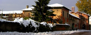
Lorenteggio kept its rural character until the late 19th century, its territory being partitioned into several cascine (farmhouses), some of which existed well into the 20th century. In the 20th century, Lorenteggio was annexed to Milan, and a quick urbanization and industrialization process started. The industrial development of the area was boosted by the construction of the railway connecting Milan to the south-west of Lombardy, in the early 1900s; the San Cristoforo railway station, completed in 1909, is still in operation. One of the most famous factories that were established in Lorenteggio is that of the Osram lighting manufacturer. [1]
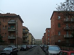
Massive construction of apartment blocks in Lorenteggio began in the mid 20th century. The district today is completely urban, with the last remainders of the rural landscape being only found past the boundary of Corsico.
Notable people and references in popular culture
Giambellino-Lorenteggio is a very populous district, where a large number of immigrants settled during the economic boom of Milan in the 1960s. At the same time, it was not as isolated or far from the historic centre of Milan, and from the Milanese tradition and culture, as was the case with so called "dormitory" districts (e.g., Gratosoglio or Ponte Lambro). This resulted in the district being, in the 1960s and 1970s, a sort of cultural melting pot, which yielded a generation of talented "new" Milanese (usually coming from proletarian families of southern origin) who became famous in different fields.
The most prominent name to be associated to the Giambellino is possibly that of singer-songwriter Giorgio Gaber, who brought the district to national fame with his extremely popular song La ballata del Cerutti ("The ballad of Cerutti"). The song describes daily life in the "Bar Gino" (a bar in Giambellino) in the 1960s. The bar actually existed, and Gaber was a regular there, along with Bobby Solo, Adriano Celentano, Ricky Gianco and Gino Bramieri, all of which would later gain national or international fame (the former three as singers, the latter as a comic actor). Actor and screenwriter Diego Abatantuono, who grew up in Lorenteggio, has declared to have taken inspiration from his memories of the people of Giambellino and Lorenteggio for some of his roles and to have a predilection for this district as a setting for his movies. [4] [5] Other notable people who lived in this district include actor Ugo Conti and journalist Enrico Mentana and, reportedly, Silvio Berlusconi (at least, he was registered in the electoral district of Via Soderini when he was young). One of the most popular Italian rock bands of the 1970s, I Camaleonti, rose from the ranks playing in cheap music clubs in Giambellino.
Popular Italian writer Andrea G. Pinketts has often declared to have spent much time in the small bars and clubs of Giambellino and Lorenteggio to find inspirations for his hardboiled novels.
Gorla is a district ("quartiere") of Milan, Italy. It is part of the Zone 2 administrative division, located north-east of the city centre. Before 1923, Gorla was an independent comune. The name "Gorla" is probably derived from the latin word gulula, meaning "little cleft".
Greco is a district ("quartiere") of Milan, Italy, part of the Zone 2 administrative division, located north-east of the city centre. Before being annexed to the city of Milan it was an independent comune, named Greco Milanese. As "Greco" is the Italian word for Greek, it has been suggested that the name refer to an old Greek settlement in the area; nevertheless, scholars tend to believe that the place was actually named after the Greco family that used to live here.
Taliedo is a peripheral district ("quartiere") of the city Milan, Italy, part of the Zone 4 administrative division, located south-east of the city centre. The informal boundaries of the district are three main city streets, respectively Via Mecenate, Via Bonfadini and Via Salomone.

Nosedo is a district ("quartiere") of the city of Milan, Italy. It is part of the Zone 4 administrative division, located south of the city centre. Until 1870, it was an autonomous comune. The name comes from the Latin nocetum, meaning "walnut forest", as walnut trees used to be common in the area.

Rogoredo is a former municipality, currently border district ("quartiere") of the city of Milan, Italy. It is part of the Zone 4 administrative division, and it is located 6–7 km south-east of the city centre. It borders on the Nosedo district to the east, on the Morsenchio district to the north, on the piazzale Corvetto neighbourhood to the north-west, and on the San Donato Milanese comune to the south-east. The name derives from the medieval Latin word robur, meaning "sessile oak, and stands for "oak wood".
Vigentino is a district ("quartiere") of Milan, Italy, part of the Zone 5 administrative division, located south of the city centre. Before 1923, Vigentino was an autonomous, rural comune. By the mid 20th century, agricultural activities were dismissed, and the area was largely urbanized, with the construction of large apartment blocks.
Vaiano Valle is a rural district ("quartiere") of Milan, Italy, part of the Zone 5 administrative division. It is located south of the city's urban area, within the Parco Agricolo Sud Milano nature reserve. Before 1869, it was an autonomous comune.

Gratosoglio is a district (quartiere) of the city of Milan, Italy, part of the Zone 5 administrative division. It is located at southernmost end of the city, bordering on the comune of Rozzano, and it is traversed by the Lambro river.
Quintosole is a district ("quartiere") of Milan, Italy, part of the Zone 5 administrative division. It is a rural district, located within the Parco Agricolo Sud Milano nature reserve, south of Milan's urban area. Before 1869, it was an autonomous comune.
Barona is a border district ("quartiere") of the city of Milan, Italy. It is part of the Zone 6 administrative division, and it is located south of the city centre. Its population can be roughly estimated to 85,000. It borders on the comunes of Buccinasco, Assago, and Corsico and the districts of Lorenteggio and Torretta. Its boundaries are marked by the Parco Agricolo Sud Milano nature reserve to the south, by the Naviglio Grande and Naviglio Pavese canals to the east and to the west, and by the Circonvallazione ring road to the north.

San Cristoforo sul Naviglio, or San Cristoforo for short, is a district ("quartiere") of Milan, Italy, part of the Zone 6 administrative division of the city. It is named after its most important monument, the Romanesque-Gothic church of San Cristoforo sul Naviglio. The district is located along the Naviglio Grande canal, south of Giambellino-Lorenteggio.
Ronchetto sul Naviglio is a district ("quartiere") of Milan, Italy, part of the Zone 6 administrative division of the city. Before being annexed to Milan, it has been an autonomous comune until 1870, and a frazione of Buccinasco between 1870 and 1923.
Quarto Cagnino is a district (quartiere) of Milan, Italy, part of the Zone 7 administrative division of the city. It borders the districts of Trenno (north), San Siro (east), Baggio (south), and Quinto Romano (west). Before being annexed to Milan, in 1869, it was an autonomous comune and, briefly, a part of Trenno.
Baggio is a district (quartiere) of Milan, Italy, part of the Zone 7 administrative division of the city. Before being annexed to Milan in 1923, it was an autonomous comune.

Affori is a ward of Milan, Italy, part of the Zone 9 administrative division of the city, located north of the city centre. It borders with the wards of Bruzzano, Comasina, Bovisasca, Dergano and Niguarda. Before being annexed to Milan in 1923, it was an autonomous comune.

Parco Agricolo Sud Milano is a large protected rural area located south and south-east of Milan, Italy. The park was established in 1990 with the purpose of preserving, safeguarding, and enhancing the natural and historical heritage of the Po Valley. It is 47,000 hectares wide and shaped like a half-circle, located between Milan and the southern border of its Province. It also connects two other large protected natural areas: Ticino Park to the west and Adda Park to the east.
Corpi Santi di Milano is a former Italian comune, established in 1782 and annexed to Milan in 1873. It comprised the rural territory around the city walls of Milan. It was originally known just as Corpi Santi; "di Milano" was added in 1859, possibly to avoid confusion with the comune with the same name located in the area of Pavia.

The Oratorio di San Protaso is a church in via Lorenteggio, Milan, Lombardy.
The Gemini Center is an office complex comprising two skyscrapers located in Milan, Italy, at the most peripheral end of Via Lorenteggio, in the Giambellino-Lorenteggio district, adjacent to Milan's border with Corsico. The two towers are 96 m, 21 stories high; they were designed by architects R. Gantes and R. Morisi.

Line 4 is a new underground rapid transit line under construction in Milan, Italy, part of the Milan Metro. The line was planned to be completed in 2015, as part of the works for the upcoming Milan Expo. However, delays in planning, financing and construction works forced to postpone the opening, and the line is now expected to open between 2021 and 2023.