Ronchetto sul Naviglio is a district ("quartiere") of Milan, Italy, part of the Zone 6 administrative division of the city. Before being annexed to Milan (in 1923), it has been an autonomous comune until 1870, and a frazione of Buccinasco between 1870 and 1923.
Ronchetto is probably named after an ancient cascina (farmhouse) by that name; in turn, the name of the cascina is derived from the Lombard word ronch, which refers to different types of cultivated areas.[1]
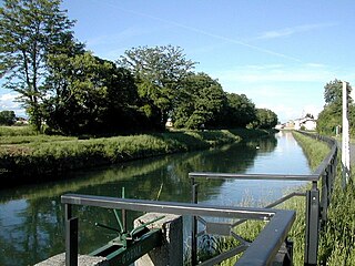
The original structure of the once rural settlement of Ronchetto is almost completely unrecognizable in the modern district, which has experienced a massive urbanization process in the 20th century and is now seamlessly connected to the urban agglomeration of Milan. A landmark of Ronchetto is a modern, 700-metre-long (2,300ft) bridge that crosses both the Naviglio Grande canal and the Milan-Mortara railway, connecting Ronchetto to the Giambellino-Lorenteggio district.
The district has been experiencing a long period of decay and is often described as a degraded area.[2] The Duomo Connection trial of the late 1980s revealed the extensive activity of the Mafia in the district.[3]
Ronchetto sul Naviglio is also remembered as the scene of a battle between Italian partisans and the German army, occurred on 25 April 1945, i.e., the very day when Italy proclaimed its liberation from the German rule.
Footnotes
↑ See P. Boselli, Toponimi lombardi, SugarCo, Milan 1977, p. 242; and F. Cherubini, Vocabolario milanese-italiano, volume 4, Regia Stamperia, Milan 1843, p. 73
The Naviglio della Martesana is a canal in the Lombardy region, Northern Italy. Running from the Adda river, in the vicinity of Trezzo sull'Adda, to Milan, it was also known as Naviglio Piccolo. It is part of the system of navigli of the Milan area.
Cernusco sul Naviglio is a town and comune in the Metropolitan City of Milan, Lombardy, northwestern Italy. With a population of 33,436 as of 2015 it is the 14th-largest municipality in the metropolitan city.
Buccinasco is a comune (municipality) in the Metropolitan City of Milan in the Italian region Lombardy, located about 7 kilometres (4 mi) southwest of Milan.
Monluè is a district ("quartiere") of Milan, Italy, part of the Zone 4 administrative division, located east of the city centre. It is a small residential district that originated as a rural settlement. As a consequence of its isolation from the city proper, it has maintained wide green areas and the general appearance of a small country town. The prominent landmark of the district is the eponymous Cascina Monluè, an ancient abbey built by the Humiliati religious order, that has been later adapted as a cascina (farmhouse) and is now used as the venue for a number of concerts and cultural events, especially in summer. Also of interest is the Church of Saint Lawrence, also built by the Humiliati in the 13th century.
Taliedo is a peripheral district ("quartiere") of the city Milan, Italy, part of the Zone 4 administrative division, located south-east of the city centre. The informal boundaries of the district are three main city streets, respectively Via Mecenate, Via Bonfadini and Via Salomone.
Nosedo is a district ("quartiere") of the city of Milan, Italy. It is part of the Zone 4 administrative division, located south of the city centre. Until 1870, it was an autonomous comune. The name comes from the Latin nocetum, meaning "walnut forest", as walnut trees used to be common in the area.
Porta Genova is a neighborhood ("quartiere") of Milan, Italy, located within the Zone 6 administrative division. The name "Porta Genova" means "Genoa gate"; the district is named after a city gate of the old Spanish Walls of Milan, namely that leading to Genoa, that used to be in what is now Piazza Cantore. The only remnants of the old gate are the small buildings that used to house the customs offices, which replaced the Spanish gate in the 19th Century.
Barona is a border district ("quartiere") of the city of Milan, Italy. It is part of the Zone 6 administrative division, and it is located south of the city centre. Its population can be roughly estimated to 85,000. It borders on the comunes of Buccinasco, Assago, and Corsico and the districts of Lorenteggio and Torretta. Its boundaries are marked by the Parco Agricolo Sud Milano nature reserve to the south, by the Naviglio Grande and Naviglio Pavese canals to the east and to the west, and by the Circonvallazione ring road to the north.
San Cristoforo sul Naviglio, or San Cristoforo for short, is a district ("quartiere") of Milan, Italy, part of the Zone 6 administrative division of the city. It is named after its most important monument, the Romanesque-Gothic church of San Cristoforo sul Naviglio. The district is located along the Naviglio Grande canal, south of Giambellino-Lorenteggio.
Giambellino and Lorenteggio are two historical and populous residential neighborhoods of Milan, Italy. Together, they form a district ("quartiere"), part of the Zone 6 administrative division of Milan.
Baggio is a district (quartiere) of Milan, Italy, part of the Zone 7 administrative division of the city. Before being annexed to Milan in 1923, it was an autonomous comune.
Assiano is a rural district ("quartiere") of Milan, Italy, part of the Zone 7 administrative division. It is a border district, at the western end of the city area. Before being annexed to Milan, it was an autonomous comune, except for a brief period (1808-1816) when it was included in Cusago.
Muggiano is a district (quartiere) of Milan, Italy, part of the Zone 7 administrative division of the city. It is located in western periphery, bordering on the comunes of Cesano Boscone, Cusago, Settimo Milanese, and Trezzano sul Naviglio. Before being annexed to Baggio, which in turn was annexed to Milan, Muggiano used to an autonomous comune.
Ghisolfa is a district ("quartiere") of Milan, Italy, part of the Zone 8 administrative division of the city, located north-west of the city centre. It is named after the "Ghisolfa Bridge" overpass, part of the external Circonvallazione ring road enclosing the centre of Milan. In turn, the bridge was named after two cascine, "Cascina Ghisolfa" and "Cascina Ghisolfetta", that existed in the area before the urbanization of the mid 20th century. The bridge was completed in 1941, prolonged in the 1960s, and enlarged in the 1990s.
Roserio is a district ("quartiere") of Milan, Italy, part of the Zone 8 administrative division of the city. It is the northernmost district, bordering on the comune of Baranzate. Before being annexed to Milan, it has been an autonomous comune, as well as part of Bollate and of Musocco.
Trenno is a district ("quartiere") of Milan, Italy, part of the Zone 8 administrative division of the city. It borders on green areas to the north and west and to the south ; to the east, it is adjacent to the Gallaratese district. Before being annexed to Milan, in 1923, it was an autonomous comune.
The Zone 6 of Milan is one of the 9 administrative zones of Milan, Italy. It corresponds to the south-western zone of the city.
Cernusco sul Naviglio is a suburban station on Line 2 of the Milan Metro in the municipality of the same name.
Villa Fiorita is a suburban station on Line 2 of the Milan Metro in the village of Villa Fiorita, which is in the municipality of Cernusco sul Naviglio.
Conca del Naviglio is a district ("quartiere") of Milan, Italy, part of the Zone 1 of Milan. It preserves the remains of the basin and some remains of the Milan amphitheatre. The urban fabric originated around the creation of the Conca di Viarenna in the 15th century.
This page is based on this Wikipedia article Text is available under the CC BY-SA 4.0 license; additional terms may apply. Images, videos and audio are available under their respective licenses.