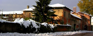
Crescenzago is a district ("quartiere") of Milan, Italy, part of the Zone 2 administrative division, north-east of the city centre. It became part of Milan in 1923; prior to that, it was an independent borgo (town). The town is traversed by the Naviglio Martesana canal. The district houses several historical buildings, most notably a 12th Century abbey and several villas from the 18th Century. It also has notable green areas, such as part of the Lambro park, as well as industrial archeological features, most notably the abandoned Ovomaltina factory.
Gorla is a district ("quartiere") of Milan, Italy. It is part of the Zone 2 administrative division, located north-east of the city centre. Before 1923, Gorla was an independent comune. The name "Gorla" is probably derived from the latin word gulula, meaning "little cleft".
Lambrate is a district (quartiere) of Milan, Italy, located within the Zone 3 administrative division, 6 km north-east of the city centre. It owes its name to the Lambro river that traverses the area. Lambrate houses one of the major railway stations of north-eastern Milan, the Stazione di Milano Lambrate. The district is also well known for Parco Lambro, a large urban park established in 1934. The famous Lambretta motor scooter was manufactured in Lambrate, and named after this district, as is Birrificio Lambrate, a craft brewery established in 1996.

Nosedo is a district ("quartiere") of the city of Milan, Italy. It is part of the Zone 4 administrative division, located south of the city centre. Until 1870, it was an autonomous comune. The name comes from the Latin nocetum, meaning "walnut forest", as walnut trees used to be common in the area.

Rogoredo is a former municipality, currently border district ("quartiere") of the city of Milan, Italy. It is part of the Zone 4 administrative division, and it is located 6–7 km south-east of the city centre. It borders on the Nosedo district to the east, on the Morsenchio district to the north, on the piazzale Corvetto neighbourhood to the north-west, and on the San Donato Milanese comune to the south-east. The name derives from the medieval Latin word robur, meaning "sessile oak, and stands for "oak wood".
Vigentino is a district ("quartiere") of Milan, Italy, part of the Zone 5 administrative division, located south of the city centre. Before 1923, Vigentino was an autonomous, rural comune. By the mid 20th century, agricultural activities were dismissed, and the area was largely urbanized, with the construction of large apartment blocks.
Vaiano Valle is a rural district ("quartiere") of Milan, Italy, part of the Zone 5 administrative division. It is located south of the city's urban area, within the Parco Agricolo Sud Milano nature reserve. Before 1869, it was an autonomous comune.

Chiaravalle is a district (quartiere) of Milan, Italy, part of the Zone 5 administrative division of the city. It is located in the periphery south of the city centre, within the Parco Agricolo Sud Milano nature reserve.
Quintosole is a district ("quartiere") of Milan, Italy, part of the Zone 5 administrative division. It is a rural district, located within the Parco Agricolo Sud Milano nature reserve, south of Milan's urban area. Before 1869, it was an autonomous comune.
Barona is a border district ("quartiere") of the city of Milan, Italy. It is part of the Zone 6 administrative division, and it is located south of the city centre. Its population can be roughly estimated to 85,000. It borders on the comunes of Buccinasco, Assago, and Corsico and the districts of Lorenteggio and Torretta. Its boundaries are marked by the Parco Agricolo Sud Milano nature reserve to the south, by the Naviglio Grande and Naviglio Pavese canals to the east and to the west, and by the Circonvallazione ring road to the north.

Giambellino and Lorenteggio are two historical and populous residential neighborhoods of Milan, Italy. Together, they form a district ("quartiere"), part of the Zone 6 administrative division of Milan.
Quarto Cagnino is a district (quartiere) of Milan, Italy, part of the Zone 7 administrative division of the city. It borders the districts of Trenno (north), San Siro (east), Baggio (south), and Quinto Romano (west). Before being annexed to Milan, in 1869, it was an autonomous comune and, briefly, a part of Trenno.
Figino is a district ("quartiere") of Milan, Italy, part of the Zone 7 administrative division. It is located north-west of the centre, within the Parco Agricolo Sud Milano nature reserve. Before being annexed to Milan, in 1869, it was an autonomous comune, named Figino di Milano.
Baggio is a district (quartiere) of Milan, Italy, part of the Zone 7 administrative division of the city. Before being annexed to Milan in 1923, it was an autonomous comune.
Assiano is a rural district ("quartiere") of Milan, Italy, part of the Zone 7 administrative division. It is a border district, at the western end of the city area. Before being annexed to Milan, it was an autonomous comune, except for a brief period (1808-1816) when it was included in Cusago.
Muggiano is a district (quartiere) of Milan, Italy, part of the Zone 7 administrative division of the city. It is located in western periphery, bordering on the comunes of Cesano Boscone, Cusago, Settimo Milanese, and Trezzano sul Naviglio. Before being annexed to Baggio, which in turn was annexed to Milan, Muggiano used to an autonomous comune.
Trenno is a district ("quartiere") of Milan, Italy, part of the Zone 8 administrative division of the city. It borders on green areas to the north and west and to the south ; to the east, it is adjacent to the Gallaratese district. Before being annexed to Milan, in 1923, it was an autonomous comune.
Bicocca is a district ("quartiere") of Milan, Italy, part of the Zone 9 administrative division. It was incorporated in the city in 1841. The main historic landmark of the district is the 15th century Villa Arcimboldi. In the last decades of the 20th century, the district has been subject to a major requalification project that led to the construction of important facilities such as the University of Milan Bicocca seats and the Teatro degli Arcimboldi theatre.

The Zone 2 of Milan is one of the 9 administrative zones of Milan, Italy. In the "sunburst" geometry of the zones of Milan, Zone 2 is the slice that connects the centre to the periphery in the north-east direction.

The Municipality 9 of Milan is one of the 9 administrative zones of Milan, Italy. It corresponds to the northern area of the city.