Quartiere Varesina is a small district, quartiere, of Milan, located in the suburban north-west part of the city. It belongs on the Zone 8 administrative division of the city.
Its name derived from Strada della Varesina, meaning Road for Varese, the pre-alpine city 50km. at north of Milan.
Characteristics
Quartiere Varesina is a highly urbanized district located to east of Via Varesina, having Viale Espinasse as central axis that extends from Piazzale Accursio up to the Svincolo of Viale Certosa. The district does not have a definite urban plan, developed as the industrial outskirts of the city, with few green spaces created. The industrial part of the neighborhood is changing even in the 21st century..
The quarter's name is derived from an ancient road, Strada della Varesina, now less important than in the past when it was the only road from Milan towards Varese, even if, the name, Via Varesina, remained. Furthermore, Via Varesina is the demarcation of a side of the neighborhood and not its axis. The neighborhood for his difference is often indicated with the name of one of its streets, Espinasse, or with known locations or areas that are located in its vicinity, Certosa, Highway for Lakes, Viale Certosa, Musocco, Garegnano or pairs of names Varesina-Espinasse, Certosa-Musocco and so on.
A bit of numbers:
Via Varesina measures 1.7km.
the stretch of Viale Certosa belonging to the district, between Piazzale Accursio and Svincolo Viale Certosa, is 1.4km. long
The border with Svincolo Viale Certosa between Viale Certosa and railway 900 m.
From the quarter you are accessing strategic areas:
city center is not longer than 6km., reachable from one big street Viale Certosa
Quartiere Varesina occupies part of the surface of the Musocco municipality abolished in 1923 which began from Strada della Varesina and bordered to Milan along Cagnola. The boundary of the district to the city is similar to that subdivision, despite the transformations that have occurred, indicated as Piazzale Accursio perimeter and the adjacent streets connecting to the beginning of Via Varesina.
Three new main roads
The driveway for Lakes Highway in 1930.
The district is delimited in the second half of the nineteenth century by Strada della Varesina and with the construction of three great ways that change the geography, clearly separating the old centers:
Viale Certosa going from the city to Greater Cemetery of Milan at the end of 1800s
the driveway to Lakes Highway, separating Garegnano's borgo from its preeminent church, Certosa di Garegnano built in 1300.
The new driveway for Lakes Highway, bisects Garegnano, leaving the Certosa di Garegnano on one side and the village of houses on the other. In fact, the old village of Garegnano, Garegnano Marcido, in the new geography then becomes part of Quartiere Varesina. This division between the two areas is even more clear with the construction of the flyover del Ghisallo in 1960.
Quartiere Varesina encompasses, at the time of the dissolution of Musocco municipality, Garegnano Marcido village, the houses along Strada della Varesina from Cagnola to the railway, the historic core around the current Piazzale Santorre of Santarosa, up to the driveway of the newly inaugurated Lakes Highway, becoming an industrial suburb of Milan.
Analysis of the area
In the development of the area between these main roads, you can find a division at the height of Piazzale Santorre di Santarosa:
the south with:
Viale Carlo Espinasse, parallel street of Via Varesina, as the major axis south–north
develops mainly for residential use being closer to the city center
Viale Espinasse highly populated
proximity to the area indicated as Cagnola
reference church: Saint Marcelina and Saint Joseph, Viale Espinasse, 85
the north with features:
Via Barnaba Oriani as the major axis east–west, ancient connection between Strada della Varesina and Certosa di Garegnano
undergoes a predominantly industrial development being proximity to the exit from Milan
Viale Espinasse uninhabited
vicinity to Milano Certosa railway station
reference church: Certosa di Garegnano
Via Ludovico di Breme built in the early nineteens can be considered as a dividing line between these two areas.
Center of the district
The center of the neighborhood can be considered Piazzale Santorre di Santarosa which is the junction of the district and the nearby church of Viale Espinasse, 85.
A church dedicated to Saint Marcellina and Saint Joseph, commissioned in 1958 by Cardinal Montini. It was consecrated to St. Marcellina by Cardinal Carlo Maria Martini, Archbishop of Milan, December 9, 1983 and then also dedicated to St. Joseph, to which was added the suffix to the Certosa, with clear reference to the nearby Certosa di Garegnano. The square in front of it was used for parking until the end of the 1990s, when the surrounding area became a garden and a recreational point with an attached oratory, football field and locker room.
Shops cluster around Viale Espinasse, noted by a tramway, currently with 19 line. The old shops are now extinct, remain bar, call centers, real estate agencies, ethnic clubs, hairdressers, a hotel, a pharmacy, a bank and the shopping center Billa.
Prominent buildings
Piazzale Santorre di Santarosa
In Piazzale Santorre di Santarosa we find:
the old seat of the municipality of Musocco, at No. 10, became in time even Casa del Fascio and now Green Cross Sempione[2] home
Few meters further at Via De Rossi, 2 there is the primary schoolAlfredo Cappellini.
In Viale Espinasse, corner Viale Certosa, in 1951 was built the service station Agip, designed by the architect Mario Bacciocchi, which still exists but only partially used. The structure of the station, which combines the right angle of the two boulevards, looks like a ship that rises from the road surface, giving a sense of dynamism and plasticity, a work considered to be of architectural merit.[3]
20th century
The history and growth of the district is related to its position as a crossroads for the North-West of the province and the region to Novara, Varese, Como and its distance from the center of Milan, about 6–7km.
Housing
The part of the district along the axis of Viale Espinasse up to Piazzale di Santorre Santarosa is rapidly built for residential use from the 30s. The passage of the tram along the way, if on the one hand contributes to the noise, on the other gives rise to shops and stores for the visibility of the road. In the streets that intersect it, Via Marcantonio dal Re, Via Casella, Via Mola, Via Nuvolone, arise a mixture of small businesses, buildings, small houses still partly standing. Engine of development of the area is also nearby, just a few hundred meters, automobile factory Alfa Romeo at Portello which employs thousands of workers, reducing activity from the 60s onwards, until the end of the 80s. Over time, small companies in the area gradually give way to new homes, meanwhile shops and stores are anyway replaced by new businesses, such as Standa opened a shopping center, Fiat and Opel a dealership. At the end of the 90s is completely redone the road surface, uneven for years for the passage of trams.
The old farmhouse of Via Barnaba Oriani, 44-48
The expansion of housing for the part of the quarter in proximity of Svincolo Viale Certosa, is later for industrial presence in its territory, and since the 60s and 70s onwards. The ancient road connecting to the Charterhouse of Garegnano, Via Barnaba Oriani, changes its appearance. The latest farms, in the half way, in the 70s and 80s are replaced from buildings of 7-9 floors with the adjacent Via Pannunzio, gradually erasing any memory of the old village Garegnano Marcido. No trace remains today of the birthplace of Barnaba Oriani and the villa of Petrarch origin.
Even the gardens of Via Trapani in time disappear and only the farm house numbers 44 and 48 with the Osteria del 48 and some home degraded reminiscent of the old village. The traffic changes, the one-way between Viale Espinasse and Via Luciano from the direction toward the Certosa, has been directed to Viale Espinasse to alleviate traffic along the inhabited part.
In the 90s the shrine with the painting of The Virgin and Child of the old oratory at No. 29 was replaced with a copy, moved a few feet and placed between two concrete walls.
In 1994 in Via Perin del Vaga, Villapizzone CDA, a little football team, transferred its home in a new soccer center with stands and locker rooms.
The municipal building of Via Ludovico di Breme, 59 which in the past had been a nursing home was demolished at the end of the 90s and the space is now lying unused.
Viale Certosa, traditional access to the city and close to the Fieramilanocity, is the ideal place to be able to welcome tourists or people engaged in business. Arise at the intersection of Via Casella, Hotel Casella, 104-106, which becomes enlarged Hotel Mirage and Hotel Raffaello, 108. At 184-200 you instead build the barracks popular, local residents grow considerably. Towards the avenue of plane trees a series of windows of buildings, are largely catering facilities or service centers and at the intersection with Via Polidoro da Caravaggio, numbering 150, a Buffetti Group shop, office products.
Via Varesina still houses the living quarters with older buildings, and here time seems to stand still. Commercial spaces see bars, pizzerias and dining establishments. Post office at Via Varesina, 161-163 closes at the end of the 80s.
The district does not have green spaces: the only public flowerbed is on the side of house numbers in Piazzale Accursio. The trees in the neighborhood are only the sycamores in Viale Certosa.
Foreign immigration is relevant as in the rest of the periphery of the city, mainly concentrated in Via Varesina and Viale Certosa.
The interior of the district as a whole is a collection of buildings of businesses and homes in most recent, built after 1980, while the area around Viale Espinasse has undergone the least change.
Industry
From 1930 onwards, the industrial growth raises in the neighborhood the first companies, small and medium-sized enterprises with buildings and smaller laboratories. The ability to transport goods without entering the city and easy access to the area for workers from outside or from Milan has contributed to its industrial vocation.
Even the Milano Certosa railway station was used to transport goods: a railroad from Alfa Romeo at Portello came in the neighborhood in Via Giovanni da Udine, ran through the present Via Pannunzio to go through the fields in Via Alassio where it entered in the station, time that look far away as slightly different is the geography of the district. Still remains, however, a small stretch of the track of that railroad in Via Giovanni da Udine, Viale Certosa corner.
Over time, especially from the 70s onwards, small industrial activities have been converted, closed or relocated. The industrial goods were replaced by companies that offer industrial services. In this way, there has been a gradual shift to larger buildings and modern.
The perimeter of the streets Via Ludovico di Breme, Via Galliari, Locchi, Via Giovanni da Udine, Via Brunetti, Via Alassio, Via Cantoni are entirely industrial, as well as Via Montefeltro.
Multinational companies settled in the area in the twentieth century are:
Bayer with the offices in a building with large windows in Viale Certosa, 230
De Agostini with offices in a modern building isolated alongside Svincolo Viale Certosa in front of the Certosa di Garegnano in Via Montefeltro, 6/B
Sandvik, with a large settlement in Via Varesina, 184
Richemont, luxury brands, Via Ludovico di Breme, 45 corner Via Locchi, which since 2011 has moved its headquarters
Other notable companies:
Asystel, Information Communication Technology, from 80's with its two offices in Via Perin del Vaga, 16 and Viale Certosa, 220
Hesa, electronic security and surveillance cameras, Via Triboniano, 25
Italmondo, logistics, Viale Espinasse, 163
Italtriest, operating in the field of advertising, Via Ludovico di Breme, 79 from 1952
Rima, bearings, Via Brunetti, 10
Pelikan, Via Alassio, 10, has closed this site in the late 90
Danielli, plastics, closed in 2003, its historic headquarters in Via Montefeltro, 4
It's remarkable the presence in the district of activities related to the sale and repair of cars: dealerships, workshops, bodyshops. In 1971, the subsidiary Renault is built in Viale Certosa, 144 on 12,000m2 (129,167sqft) then closed in the early 2000s. Mitsubishi creates its exhibition space in the 80s in Viale Certosa 146-148, with assistance in the adjacent streets, Via Polidoro da Caravaggio and Giovanni da Udine. In 2012 the branch closes as the Fiat dealership did in Viale Espinasse, 110 at the end of the 90s.
In Viale Espinasse, 137 with an old door entry, you will find a home of Milan Automobile Club d'Italia. Within the same area a historical body of district Carrozzeria Monte Altissimo.
The 2000s
The process of transformation of the neighborhood did not stop for the part of the district closer to Svincolo Viale Certosa.
The industrial crisis has accelerated changes for the neighborhood, creating abandoned areas. Part of the new spaces have been converted into dwellings, other into new offices with a tendency to verticality of the area. In general, the district suffers from the lack of a subway station.
In Via Montefeltro arise new offices of 8-9 floors as at number 6 with Euronics. The historical site of Danielli, with its buildings in Via Montefeltro, 4 is being replaced with a modern glass skyscraper completed in 2005, which houses offices of the Binda Group, watches. The presence of the old company in the district remains by the long-kept flower beds in Via Barnaba Oriani.
The Double Tree hotel owned by the Hilton was built in 2010 in Via Ludovico di Breme, 77 on the spaces vacated by the downsizing of Italtriest, enlivening the neighborhood with a large foreign presence even in passing. Casaforte, a hotel of things, replaces Pelikan in the space of Via Alassio, 10
Many activities with the crisis in the car are closes as branches of Renault and Mitsubishi, while also creating new opportunities. Opel moved to Via Mola, 48 corner Via Ludovico di Breme, with SempionCar that ends in 2012. BMW Motorrad opens in Via Ludovico di Breme, 2.
McDonald's opens at Viale Certosa, 134 in a building that was previously a nightclub and at No. 228 corner of Piazzale dei Laghi, with the renovation of the historic Shell service station is built a Burger King and an Autogrill bar. Also in the first decade are opened a Penny Market in Viale Espinasse, 136 and a Lidl in Via Giovanni da Udine, 28 which replaces a point of sale of Bergamaschi and Vimercati, household items, Billa takes over Standa in Viale Espinasse.
For the road the extension of the tram line 12 from Via Console Marcello to Roserio saw the construction of the tracks in Via De Rossi with new traffic lights in Piazzale Santorre di Santarosa, while the tram line 33 ceases its passage in the district after 50 years with tram type 1928.
In 2005 the Church of Our Lady of Good Help, also called the Sanctuary of Our Lady of Perpetual Help, a prefab built in 1959 in Via Brunetti corner Piazzale Cacciatori delle Alpi, in which it was not regularly celebrated mass was demolished.
Roads and transports
Roads
Viale Certosa is the busiest arterial road of the neighborhood, with its traffic out of the city crossing the Svincolo Viale Certosa access all the directions of Lake Highway and Highway Torino-Venezia.
The other two-way parallel sliding of the district, Via Varesina and Viale Espinasse, along with Via Console Marcello in Villapizzone share the traffic for Via Palizzi Bridge and quarters Quarto Oggiaro and Vialba.
The opening of a new entrance to Svincolo Viale Certosa in the 90s, at the corner of Via Brunetti and Via Alassio, has streamlined the circulation of the district as vehicles coming from Quarto Oggiaro Vialba can access to Svincolo only ran along the neighborhood without going along Via Ludovico di Breme and Viale Certosa. Access to the new entrance is from the end of Viale Espinasse.
In 1995 the old Palizzi bridge that cleared the Torino-Milano railway, allowing the access to the district Vialba and Quarto Oggiaro, has been tear down. The circulation of the old bridge through which passed both trams that private vehicles has been replaced by two new bridges, one for private means and one for the trams. The new bridge also has a way out for Via Console Marcello at Villapizzone. The viability of the area has improved greatly.
Transports
The district is well served by public transport, train, bus or tram. There are no subway lines.
Movibus suburban lines: z602 for Legnano, z603 for San Vittore Olona, z617 for Lainate/Origgio
Airpullman: 560 Milano QT8 - Arese
Autostradale, Sadem: Milano - Torino
Viale Certosa, 130 stop:
ATM z301 Milano-Bergamo
ATM bus:
lines 40 Bonola M1 - Niguarda Parco Nord
lines 57 Cairoli - Quarto Oggiaro
Tram:
line 1 Piazza Castelli - Greco (2 rides in the early morning start from Piazzale Cacciatori delle Alpi)
lines 12 Viale Molise - Roserio carried out with tram ATM Class 4900
lines 19 Porta Genova - Roserio carried out with tram ATM Class 1500, as known as the twenty-eight
Since 2000, we have followed various modifications of terminus: 19 started at Via Cantù and 33 arrived in Remembrance of Lambrate. The outer terminus of the line 33 was first moved to Piazzale Cacciatori delle Alpi, then the line, in 2007, was finally removed with its temporary replacement by line 7, and then 11, became in a short time removed.
The line 12 route in the district is recent, from the 2000s onwards, with the extension of the line from the terminus of Via Console Marcello at Villapizzone up to Roserio.
The tram terminus of Piazzale Cacciatori delle Alpi is currently unused, apart from the two rides of line 1, is sometimes used as a temporary terminus for problems on the movement of trams or when the outer one of Roserio is unreachable. The terminus was a strategic hub for the area, for its proximity to the Milan Certosa station. With the extension of the tram lines in Roserio and the station proximity to the stop of Via Palizzi, in Vialba, its importance has failed.
The area
Boundaries
The district borders:
West: Garegnano with partition Ghisallo Bridge, Svincolo Viale Certosa
Tram Line 14 passes through the side of Viale Certosa in Boldinasco, but in fact only a few meters from the neighborhood. The route of the line is Lorenteggio - Cimitero Maggiore
List of streets
Piazzale Accursio ( From Via Sonnnino to Viale Espinasse, even numbers )
↑ The photo was taken at the intersection of Via Barnaba Oriani and Piazzale ai Laghi in direction Svincolo Viale Certosa. The street in the foreground is now occupied by the flyover of the Ghisallo. You can see on the left the Certosa of Garegnano.
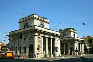
Porta Venezia is one of the historical gates of the city of Milan, Italy. In its present form, the gate dates back to the 19th century; nevertheless, its origins can be traced back to the Medieval and even the Roman walls of the city.
Rogoredo is a former municipality, currently border district ("quartiere") of the city of Milan, Italy. It is part of the Zone 4 administrative division, and it is located 6–7 km south-east of the city centre. It borders on the Nosedo district to the east, on the Morsenchio district to the north, on the piazzale Corvetto neighbourhood to the north-west, and on the San Donato Milanese comune to the south-east. The name derives from the medieval Latin word robur, meaning "sessile oak, and stands for "oak wood".
Porta Lodovica was a city gate of the Spanish walls of Milan, Italy, named after Ludovico Sforza. Today, the name refers to the district (quartiere) of Milan where the gate used to be, which is part of the Zone 5 administrative division. The gate was demolished at the end of the 19th century; plans were made to rebuild it inside the Parco di Monza city park in Monza, but they were not implemented.
Morivione is a district ("quartiere") of the city of Milan, Italy, part of the Zone 5 administrative division, located south of the city centre. It is informally defined as the area enclosed within four streets, namely Viale Toscana, Via Ripamonti, Via Antonini and Via Bazzi. The district is especially associated to the celebrations in honour of Saint George, where Milanese people would traditionally drink milk and eat a kind of sweet called pan de mein.
Barona is a border district ("quartiere") of the city of Milan, Italy. It is part of the Zone 6 administrative division, and it is located south of the city centre. Its population can be roughly estimated to 85,000. It borders on the comunes of Buccinasco, Assago, and Corsico and the districts of Lorenteggio and Torretta. Its boundaries are marked by the Parco Agricolo Sud Milano nature reserve to the south, by the Naviglio Grande and Naviglio Pavese canals to the east and to the west, and by the Circonvallazione ring road to the north.
Porta Volta is a former city gate of Milan, Italy, part of the Spanish walls. Nowadays, the name "Porta Volta" is most commonly used to refer to the surrounding district ("quartiere"), part of the Zone 8 administrative division of the city.
Villapizzone is a district ("quartiere") of Milan, Italy, part of the Zone 8 administrative division of the city, located north of the city centre. It was an autonomous comune until 1869.
Garegnano is a district ("quartiere") of Milan, Italy, part of the Zone 8 administrative division of the city, north-west of the city centre. Before being annexed to Milan, it has been an autonomous comune, originally known as Garegnano Marcido.
Quarto Oggiaro is a district of Milan in the north-west of the city, part of Zone 8, with a population of 35000 inhabitants.
Roserio is a district ("quartiere") of Milan, Italy, part of the Zone 8 administrative division of the city. It is the northernmost district, bordering on the comune of Baranzate. Before being annexed to Milan, it has been an autonomous comune, as well as part of Bollate and of Musocco.
Milano Greco Pirelli railway station is one of the main stations serving the comune of Milan. Opened in 1914, it is in the north of the city, in the quartiere of Greco. It is part of the Milan–Monza railway.
The Milan tramway network is an important part of the public transport network of Milan, Italy.
Piola is a station on Line 2 of the Milan Metro. The station is located on the corner between Via Giovanni Pacini and Via Antonio Bazzini, just east of the Piazzale Gabrio Piola. The station serves Lambrate neighborhood and the district called Città Studi, a big urban university area comprising Politecnico di Milano and the Milan University campuses.
Milano Certosa is a surface railway station in Milan, Italy. The station is on the north-west part of the city between Quarto Oggiaro and Musocco neighborhoods. Its name comes from the Certosa di Garegnano. The station is located on Via Antonio Mambretti. The train services are operated by Trenord.
The Cimitero Maggiore di Milano, also known as Cimitero di Musocco, is the largest cemetery of Milan, Italy. It is located in Zone 8, in the Musocco district, not far from the Garegnano Charterhouse. The cemetery has an overall area of 678,624 m2 with over 500,000 graves.
The Zone 8 of Milan is one of the 9 administrative zones of Milan, Italy. It corresponds to the north-western sector of the city.
Musocco is a suppressed Italian comune, independent from the eighteenth century to 1808 and from 1815 until 1923, when the town was incorporated in Milan.
Quartiere Campo dei Fiori is a small district in Milan, Italy. The district measures 400 by 300 meters. It is located in the north-western outskirts of the city, and is a part of Zone 8.
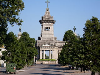
The War Memorial of Musocco commemorates the fallen of old town of Musocco during the First World War. Musocco incorporated in Milan in 1923. It's located in Piazzale Santorre di Santarosa into Quartiere Varesina covering all the four directions of the square, and it's clearly visible along Viale Espinasse.
Isola is a station on Line 5 of Milan Metro. It takes its name from the Isola (island) district of Milan in which it is located, its name derived from the neighbourhood's position cut off from the city centre by the main railway.
This page is based on this Wikipedia article Text is available under the CC BY-SA 4.0 license; additional terms may apply. Images, videos and audio are available under their respective licenses.