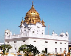
Beas is a riverfront city in the Amritsar district of the Indian state of Punjab. It is located, just 43 km from Amritsar city, the district headquarters. Beas lies on the banks of the Beas River. Beas town is mostly located in revenue boundary of Budha Theh with parts in villages Dholo Nangal and Wazir Bhullar.Beas falls in Amritsar district situated in Punjab state, with a population 55295. The male and female populations are 28921 and 26374 respectively. The size of the area is about 68.75 square kilometer. Beas railway station is the best and cleanest railway station in the india 2018. Radha Swami Beas hospital is the best Charitable Hospital in the punjab . Beas railway station is located on the boundaries of beas. And Budha Theh is a census town in Baba Bakala tehsil of Amritsar district.
Dhanaula is a city and a municipal council in Barnala district in the state of Punjab, India. Situated 18 km west of Sangrur, Ranjit kaur Sodhi w/o Harwinder singh Sodhi is president of nagar council Dhanaula lies on the Sangrur-Barnala road. It is about 12 km from Barnala. Dhanaula was founded by Gurditta, eldest son of Taloka, in 1718. It was the capital of the erstwhile Princely State of Nabha until 1755 when Raja Hamir Singh founded Nabha town and made it the capital of the state. He also built a fort which now houses the police station of Dhanaula. A temple of Hanuman exists here. It is said that a man was digging a ditch and found an idol of Hanuman. A temple was constructed at that place, the idol was placed there, and the people began to worship it. Dhanaula is a town of temples.
Badhni Kalan is a town and a nagar nigham in Moga district in the state of Punjab, India. Kalan is Persian language word which means Big.
Bariwala is a town and a nagar panchayat in Muktsar district in the state of Punjab, India.
Bhankharpur is a census town in Mohali district in the state of Punjab, India.
Bhikhiwind is a town and a nagar panchayat, just about 33 km from Tarn Taran Sahib in Tarn Taran district in the Majha region of state of Punjab, India. The town is located along the India-Pakistan border in Tarn Taran district of Punjab, India, 280 km from Chandigarh.
Dera Baba Nanak is a town and a municipal council in Gurdaspur district, in the state of Punjab, India. It is the sub-district headquarters of Dera Baba Nanak tehsil. It is 36 km away from Gurdaspur city, the capital of the district. Since November 2019, a corridor between India and Pakistan has been established at its shrine.
Garhdiwala is a town and a municipal council in Hoshiarpur district in the state of Punjab, India.
Goniana is a Suburban town in Bathinda District in the Indian state of Punjab. It is located about 12 km from Bathinda City on National Highway 54 It is also known as ‘’’Goniana Mandi’’’.

Makhu is a town and a nagar panchayat in Ferozepur district in Indian state of Punjab.
Mullanpur Garibdass is a town in Mohali district in the Indian state of Punjab, north of the city of Mohali and Chandigarh. Garibdas village is located in vicinity of this town.
Ramdass is a city, near Amritsar city and a municipal council in Amritsar district in the Indian state of Punjab. It is situated on the bank of Ravi river. It is a border area.
Sri Hargobindpur is a town and a municipal council in Gurdaspur district in the Indian state of Punjab. Situated on the banks of the Beas River Sixth Guru of Sikhs Shri Guru Hargobind Sahib ji established this city on the land bought by his Father and fifth Guru, Shri Guru Arjan Dev Sahib ji, the city is also the erstwhile capital of the Ramgarhia Misl.

Bilaspur is a census town and block headquarter in Yamunanagar District in the state of Haryana, India. It takes its name from the corrupted form of "Vyas Puri", as it was the ashram of Ved Vyasa rishi where he wrote the Mahabharta on the banks of Sarasvati river near Adi Badri where Sarasvati river leaves Himalayas and enters the plains. On Jagadhari road lies another popular religious site of Kapal Mochan.
Dhariwal is a fifth largest town and a municipal council in Gurdaspur district in the state of Punjab, India. Dhariwal was most famous for its woolen mill. This town is situated on the banks of river Upper Bari Duba and is 13 km away from Gurdaspur on the Gurdaspur-Batala highway. Dhariwal, like the rest of north-western India, features a humid subtropical climate. Average yearly precipitation is about 925mm, 70% of it receives during monsoon season (June-September). Winter is also wet. June is the hottest while January is coldest month. In winter, dense fog persists for three to five days. As a result, day temperature drops to single digits. During May and June, dust storms followed by intense spells for short intervals are not uncommon. Monsoon arrives in the end of June and withdrawal starts around the third week of September. The town is prone to heatwaves during summer and chills during winter.
Theh Kanjla is a village in Kapurthala district of Punjab State, India. It is located 8 kilometres (5.0 mi) from Kapurthala, which is both district and sub-district headquarters of Theh Kanjla. The village is administrated by a Sarpanch who is an elected representative of village as per the constitution of India and Panchayati raj (India).
Theh Kushalgarh is a village in Nakodar in Jalandhar district of Punjab State, India. It is located 27 kilometres (17 mi) from Nakodar, 35 kilometres (22 mi) from Kapurthala, 49 kilometres (30 mi) from district headquarter Jalandhar and 190 kilometres (120 mi) from state capital Chandigarh. The village is administrated by a sarpanch who is an elected representative of village as per Panchayati raj (India).
Jagatpur Theh is a village in Shaheed Bhagat Singh Nagar district of Punjab State, India. It is located 15 kilometres (9.3 mi) away from Banga, 10 kilometres (6.2 mi) from Phagwara, 26 kilometres (16 mi) from district headquarter Shaheed Bhagat Singh Nagar and 119 kilometres (74 mi) from state capital Chandigarh. The village is administrated by Sarpanch an elected representative of the village.
Saidpur Theh is a village in Shaheed Bhagat Singh Nagar district of Punjab State, India. It is located 4 kilometres (2.5 mi) away from sub post office Garcha, 13 kilometres (8.1 mi) from Nawanshahr, 6.6 kilometres (4.1 mi) from district headquarter Shaheed Bhagat Singh Nagar and 100 kilometres (62 mi) from state capital Chandigarh. The village is administrated by Sarpanch an elected representative of the village.
Surapur Theh is a village in Shaheed Bhagat Singh Nagar district of Punjab State, India. It is located 6 kilometres (3.7 mi) away from Banga, 17 kilometres (11 mi) from Nawanshahr, 10 kilometres (6.2 mi) from district headquarter Shaheed Bhagat Singh Nagar and 110 kilometres (68 mi) from state capital Chandigarh. The village is administrated by Sarpanch an elected representative of the village.

