Nellore is a city located on the banks of Penna River, in Nellore district of the Indian state of Andhra Pradesh. It serves as the headquarters of the district, as well as Nellore mandal and Nellore revenue division. It is the fourth most populous city in the state. It is at a distance of 700 km from Visakhapatnam and about 170 km north of Chennai, Tamil Nadu and also about 380 km east-northeast of Bangalore, Karnataka.

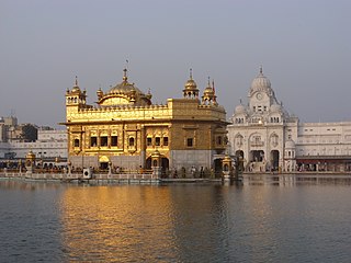
Amritsar, historically also known as Rāmdāspur and colloquially as Ambarsar, is the second largest city in the Indian state of Punjab, after Ludhiana. It is a major cultural, transportation and economic centre, located in the Majha region of Punjab. The city is the administrative headquarters of the Amritsar district. It is situated 217 km (135 mi) north-west of Chandigarh, 455 km (283 mi) north-west of New Delhi, and 47 km (29 mi) north-east of Lahore, Pakistan, with the India-Pakistan border only 28 km (17.4 mi) away.

Ludhiana(Punjabi pronunciation: [lʊdiˈɑːnə] ) is the most populous and the largest city in the Indian state of Punjab. The city has an estimated population of 1,618,879 as of the 2011 census and distributed over 310 km2 (120 sq mi), making Ludhiana the most densely populated urban centre in the state. It is a major industrial center of Northern India, referred to as "India's Manchester" by the BBC. It is also known as the Commercial capital of Punjab.
Jalandhar is a city in the Indian state of Punjab. With a considerable population, it ranks as the third most-populous city in the state and is the largest city in Doaba region. Jalandhar lies alongside the historical Grand Trunk Road and is a well-connected junction for both rail and road networks.
Muzaffarnagar is a city under Muzaffarnagar district in the Indian State of Uttar Pradesh. It is situated midway on the Delhi - Haridwar/Dehradun National Highway and is also well connected with the national railway network. It is known as the sugarbowl of Uttar Pradesh.
Mohali, officially known as Sahibzada Ajit Singh Nagar, is a planned city in the Mohali district in Punjab, India, which is an administrative and a commercial hub lying south-west of Chandigarh. It is the headquarters of the Mohali district. It is also one of the six Municipal Corporations of the State. It was officially named after Sahibzada Ajit Singh, the eldest son of Guru Gobind Singh.
Amritsar district is one of the twenty three districts that make up the Indian state of Punjab. Located in the Majha region of Punjab, the city of Amritsar is the headquarters of this district.

Mattanur, also spelled Mattannur, is a town, municipality, and an aerotropolis in Kannur district, Kerala, India. Mattanur is about 27 km east of Kannur and Thalassery, two major towns of the district.

Pathankot is a city and the district headquarters of the Pathankot district in Punjab, India. Pathankot is the 6th most populous city of Punjab, after Ludhiana, Amritsar, Jalandhar, Patiala and Bathinda. Its local government is a municipal corporation.

Ludhiana district is one of the 23 districts in the Indian state of Punjab. It is Punjab's largest district by both area and population. Ludhiana, the largest city in Punjab, is the district headquarters.
Dhilwan is a town and a nagar panchayat in Kapurthala district in the state of Punjab, India.
Mhowgaon is a Nagar Panchayat under Sub Division Dr. Ambedkar Nagar (Mhow) in Indore district in the Indian state of Madhya Pradesh. The total geographical area of Mhowgaon nagar panchayat is 13.5 km2 and it is the smallest city by area in the sub district. The population density of the city is 2309 persons per km2. Mhowgaon is divided into 15 wards for which elections are held every 5 years. Among them, Mhowgaon Ward No. 2 is the most populous ward with a population of 3440 and Mhowgaon Ward No. 15 is the least populous ward with a population of 957. Mhowgaon Nagar Panchayat has total administration over 6,373 houses to which it supplies basic amenities like water and sewerage. It is also authorized to build roads within Nagar Panchayat limits and impose taxes on properties coming under its jurisdiction.
Gampalagudem is a town situated in the NTR district of Andhra Pradesh, India. It serves as the headquarters of the Gampalagudem mandal, which is under the administration of the Tiruvuru revenue division. The town is located on the banks of the Kattaleru River and is situated at a distance of 145 km (90 mi) from the district headquarters, Machilipatnam, and 74 km (46 mi) from Vijayawada.

Janghai is a market and Gram Panchayat in the district of Prayagraj, in the Indian state of Uttar Pradesh. It is located 226 km kilometres southeast of the state capital, Lucknow, and 24 kilometres from Handia Tehsil. As of 2022, Janghai's population was about 29,000.

Punjab is a state in northern India. Forming part of the larger Punjab region of the Indian subcontinent, the state is bordered by the Indian states of Himachal Pradesh to the north and northeast, Haryana to the south and southeast, and Rajasthan to the southwest; by the Indian union territories of Chandigarh to the east and Jammu and Kashmir to the north. It shares an international border with Punjab, a province of Pakistan to the west. The state covers an area of 50,362 square kilometres, which is 1.53% of India's total geographical area, making it the 19th-largest Indian state by area out of 28 Indian states. With over 27 million inhabitants, Punjab is the 16th-largest Indian state by population, comprising 23 districts. Punjabi, written in the Gurmukhi script, is the most widely spoken and the official language of the state. The main ethnic groups are the Punjabis, with Sikhs (58%) as the dominant religious group with a Hindu (38%) minority. The state capital is Chandigarh, a union territory and also the capital of the neighbouring state of Haryana. Three tributaries of the Indus, viz., Sutlej, Beas, and Ravi, flow through Punjab.
Palam is a major residential colony located in South West Delhi. The Indira Gandhi International Airport, formerly known as Palam Airport, the main airport of National Capital Region is situated here. It is one of 70 Vidhan Sabha constituencies of the Delhi National Capital Territory in northern India.
Sukhbinder Singh Sarkaria is an Indian politician and from the Indian National Congress. He is a member of Punjab Legislative Assembly and represents Raja Sansi. He is a Punjab state cabinet minister holding the charges of the ministries of Revenue, Rehabilitation & Disaster Management and Water Resources.
"Parpodi," also known as "Raja Parpodi," is a town and a Nagar Panchayat in the Bemetara district of Chhattisgarh, India. The town is situated in the district of Bemetara in the state of Chhattisgarh, India. It has a small population and has been declared a "Nagar Panchayat" of the Bemetara district.
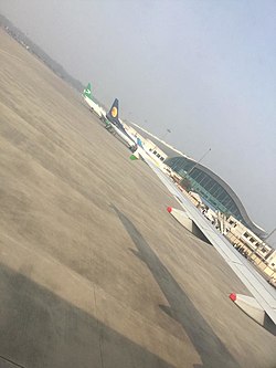
Raja Sansi Assembly constituency is a Punjab Legislative Assembly constituency that includes Rajasansi in Amritsar district, Punjab state, India.
Bhatkhedi is a Gram Panchayat under sub-division Dr. Ambedkar Nagar (Mhow) in Indore district in the Indian state of Madhya Pradesh. Total geographical area of Bhatkhedi gram panchayat is 9 km2. Mhowgaon is nearest town to Bhatkhedi which is approximately 7 km away.