
Cotuit is one of the villages of the Town of Barnstable on Cape Cod in Barnstable County, Massachusetts, United States. Located on a peninsula on the south side of Barnstable about midway between Falmouth and Hyannis, Cotuit is bounded by the Santuit River to the west on the Mashpee town line, the villages of Marstons Mills to the north and Osterville to the east, and Nantucket Sound to the south. Cotuit is primarily residential with several small beaches including Ropes Beach, Riley's Beach, The Loop Beach and Oregon Beach.

This is a list of the National Register of Historic Places listings in Barnstable County, Massachusetts.

The Provincetown Post Office is located at 217 Commercial Street in Provincetown, Massachusetts. It is located in a 2+1⁄2-story brick building that was built in 1930. The main facade has a loggia-style arcade of three arches on the first level, leading to a recessed entrance. The second story has three large windows across, and the gable end has an oculus window and dentil moulding. The building is crowned by a cupola.

The Unitarian Universalist Meeting House of Provincetown is an historic church at 236 Commercial Street in Provincetown, Massachusetts. The Greek Revival building was built in 1847 based on a design by Benjamin Hallett, for a congregation that had been established in 1829. It is a massive post and beam timber-frame construction, and was originally built without the tower. The tower, which is telescopic in form, with Greek ornamentation, is the only surviving steeple in Provincetown, and is a landmark for seafarers.

The Adams-Crocker-Fish House is an historic house in Barnstable, Massachusetts. Built about 1830, this half-Cape is a rare surviving example of a small farmstead with period outbuildings. The property was listed on the National Register of Historic Places in 1987.
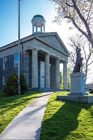
The Barnstable County Courthouse is an historic courthouse at 3195 Main Street in Barnstable, Massachusetts. The two-story Greek Revival building was built in 1831 to a design by architect Alexander Parris. It is built mostly out of Quincy granite, although its front portico and fluted Doric columns are made of wood fashioned to look like stone. The building has been expanded five times between 1879 and 1971, with each addition made in a style sensitive to its original styling, and its main courtroom features original Federal styling. The building was listed on the National Register of Historic Places in 1981, and included in the Old King's Highway Historic District in 1987. The Barnstable Superior Court is located in the building.

The Capt. Seth Baker Jr. House is a historic house in Barnstable, Massachusetts, USA. Built about 1850, it is a late example of transitional Federal-Greek Revival architecture, and a somewhat modest house built for a ship's captain. It was listed on the National Register of Historic Places in 1987.

The building at 614 Main Street in Barnstable, Massachusetts is a modest commercial building built in 1910, during the area's main period of development as a commercial district. Stylistically, the single story wood-frame building is similar to 606 Main Street, although it has more obvious Arts and Crafts features, including exposed rafters. The building has a gable roof, whose front slope includes a shed-roof dormer providing access to storage space above the stores.
237–239 Main Street is a historic commercial building located at the address of the same name in Barnstable, Massachusetts.
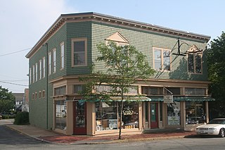
606 Main Street is a historic commercial building located in Barnstable, Massachusetts.
The Centerville Historic District is a historic district encompassing the heart of the village of Centerville in Barnstable, Massachusetts. The district extends along Main Street from a point north of its junction with Old Stage Road and Park Avenue, south to the junction with Church Hill Road. Most of the buildings in the district were built in the middle decades of the 19th century, although its oldest building, the Austin Bearse House, was built c. 1690. The area's growth was spurred by the relocation in 1826 of the Congregational Church building to its present location. The district was listed on the National Register of Historic Places in 1987.

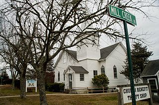
The Cotuit Historic District is a historic district encompassing the heart of the village of Cotuit in Barnstable, Massachusetts. It extends along Main Street from Lowell Street in the north to Sea Street in the south, and includes portions of Ocean View Avenue and properties on adjacent roads. The oldest properties date to the late 18th century, but saw its greatest development during the height of the area's maritime industry in the mid 19th century. In the late 19th and early 20th century the area saw new development as a summer resort area. The district was listed on the National Register of Historic Places in 1987.

The Craigville Historic District encompasses a historic religious camp meeting area in the Craigville section of Barnstable, Massachusetts, United States. It is centered on the junction of Lake Elizabeth Drive and Ocean Avenue, just west of Lake Elizabeth. The camp meeting was established in 1871 by the New England Convention of Christian Churches on land that was purchased from members of the Perry family. Along the grid of roads south of the main junction, gingerbread-decorated Gothic cottages were built over the following decades. The main tabernacle, an open-walled church, was built in 1887. The district was listed on the National Register of Historic Places in 1987.

The Old King's Highway Historic District encompasses what was historically the principal east–west thoroughfare through Barnstable, Massachusetts. It encompasses Barnstable's entire length of what is now designated Massachusetts Route 6A and called Main Street, between the town lines of Sandwich and Yarmouth. It includes more than 1,000 acres (400 ha), and includes all of the buildings whose properties front on the road, nearly 500 in all. The area includes the main population centers of Barnstable from its founding in the late 1630s until the mid-19th century, when the southern parts of the community became more significant in economic prominence. The district was listed on the National Register of Historic Places in 1987.

The Pleasant–School Street Historic District is a predominantly residential historic district in the Hyannis village of Barnstable, Massachusetts. It includes 37 properties on Pleasant and School Streets, between Main and South Streets, near the center of Hyannis. Pleasant Street was laid out in the 18th century, and School Street was laid out c. 1850, and is distinctive for its cohesive collection of Greek Revival cottages, most of which were owned by mariners active in the coasting trade. The district was listed on the National Register of Historic Places in 1987.
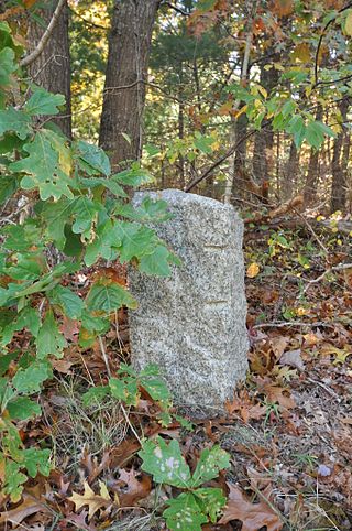
The town of Barnstable, Massachusetts has four surviving stone markers that were used in colonial days to mark the town's boundaries with its neighbors. All four are listed on the National Register of Historic Places, three of them individually, and one as part of the Old King's Highway Historic District. Barnstable was established in 1639.

The South Yarmouth/Bass River Historic District is a historic district in the southeastern part of Yarmouth, Massachusetts. It encompasses a predominantly residential area centered on a portion of Old Main Street and South Street between the villages of South Yarmouth and Bass River. The area's history is one of maritime-related industry from the late 18th to late 19th century, and then its growth as a tourist resort community. The district was listed on the National Register of Historic Places in 1990.

The Santuit Post Office is a historic post office building on Main Street in the Santuit village of Barnstable, Massachusetts. The 1+1⁄2-story wood-frame cottage was built c. 1846, and exhibits simple Gothic Revival styling reminiscent of seaside cottages that were constructed in the area between 1850 and 1875. The building served as a post office for Santuit village until the 1970s, when it was converted into a private residence.

Barnstable, Massachusetts, has more than 75 entries on the National Register of Historic Places. For listings elsewhere in Barnstable County, see National Register of Historic Places listings in Barnstable County, Massachusetts.
The South Chatham Village Historic District is a historic district encompassing much of the linear village of South Chatham in Chatham, Massachusetts. Extending eastward from the Harwich town line along Main Street, the district developed in the 18th and 19th centuries as a maritime and farming village. The district was listed on the National Register of Historic Places in 2022.


