
Caroline County is a rural county located in the U.S. state of Maryland on its Eastern Shore. As of the 2010 census, the population was 33,066. Its county seat is Denton.

Dorchester County is a county located in the U.S. state of Maryland. At the 2010 census, the population was 32,618. Its county seat is Cambridge. The county was formed in 1669 and named for the Earl of Dorset, a family friend of the Calverts.
Talbot County is a county located in the heart of the Eastern Shore of Maryland in the U.S. state of Maryland. As of the 2010 census, the population was 37,782. Its county seat is Easton. The county was named for Lady Grace Talbot, the wife of Sir Robert Talbot, an Anglo-Irish statesman, and the sister of Lord Baltimore.
Harmony is an unincorporated community in Caroline County, Maryland, United States. It is little more than an intersection of state Routes 16 and 578 on Maryland's Eastern Shore. Its original name was Fowling Creek, named after a stream nearby that is a tributary of the Choptank River.

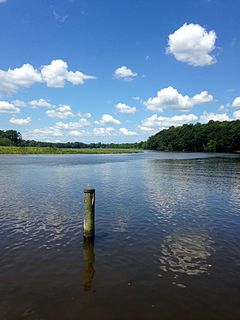
The Choptank River is a major tributary of the Chesapeake Bay and the largest river on the Delmarva Peninsula. Running for 71 miles (114 km), it rises in Kent County, Delaware, runs through Caroline County, Maryland and forms much of the border between Talbot County, Maryland on the north, and Caroline County and Dorchester County on the east and south. It is located north of the Nanticoke River and its mouth is located south of Eastern Bay. Cambridge, the county seat of Dorchester County, and Denton, the county seat of Caroline County, are located on its south shore.

American Corner is a populated place in Caroline County, Maryland, United States. American Corner is home to Colonel Richardson High School and Colonel Richardson Middle School. On older maps, it is sometimes referred to as American Corners. There was formerly a post office, cannery, blacksmith, and a store located there, as seen on the 1875 and 1897 Maps of Caroline County, Maryland.
Choptank is an unincorporated town and census-designated place on the Eastern Shore of Maryland, in Caroline County, Maryland, United States. As of the 2010 census it had a population of 129.
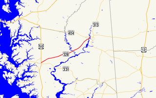
Maryland Route 328 is a state highway in the U.S. state of Maryland. The state highway runs 15.24 mi (24.53 km) from U.S. Route 50 in Easton east to just north of MD 404 in West Denton. MD 328 connects Easton with Denton, passing through eastern Talbot County and a neck of land in Caroline County between the Choptank River and Tuckahoe Creek. MD 328 was constructed in Talbot County in the late 1910s between downtown Easton and a point west of Matthews. The state highway was constructed in Caroline County in the late 1920s and early 1930s, and was originally designated MD 457. The gap between the two highways was filled in the late 1940s and included a modern bridge over Tuckahoe Creek. MD 328's western terminus was moved to US 50 in the early 1960s. In West Denton, the highway was relocated and extended north to present MD 404 in the early 1980s.
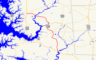
Maryland Route 331 is a 28.74-mile (46.25 km) state highway on the Eastern Shore of Maryland in the United States. The route runs from Vienna in Dorchester County northwest to Easton in Talbot County, intersecting U.S. Route 50 at both ends. MD 331 is a two-lane undivided road most of its length that passes mostly through agricultural areas. The road also passes through the communities of Hurlock and Preston along the way. It encounters several routes during its journey, including MD 14 near Rhodesdale and MD 16 in the Preston area, both of which the route forms concurrencies with. In addition, the route also intersects with MD 392 and MD 307 in Hurlock and with MD 318 near Preston.
Andersontown is a populated place on Maryland's Eastern Shore in Caroline County, Maryland, United States. It is situated near the Delaware line, centered on the intersection of Andersontown Road and Maryland Route 404.
Williston is an unincorporated town and census-designated place on the Eastern Shore of the U.S. state of Maryland, in Caroline County. As of the 2010 census it had a population of 155. It is situated between Maryland Route 16 on its eastern edge and the Choptank River on its west. It was originally known as Potter's Landing for its first resident, Zabdiel Potter. His home, Potter Hall, was listed on the National Register of Historic Places in 1982.
Two Johns, is an unincorporated community on Maryland's Eastern Shore in Caroline County, Maryland, United States. It is situated on Maryland Route 16. The name derives from two early residents who were vaudeville actors, both named John. It appears on the 1897 Map of Caroline County.
Baltimore Corner is a populated place on the Eastern Shore of Maryland, in Caroline County, Maryland, United States. It is near the Queen Anne's County line at the intersection of Maryland routes 312 and 313. It is not to be confused with Baltimore City, located on the opposite shore of the Chesapeake Bay.
Tuckahoe Creek is a 21.5-mile-long (34.6 km) tributary of the Choptank River on Maryland's Eastern Shore. It is sometimes (erroneously) referred to as the Tuckahoe River. Upstream of Hillsboro, it forms the boundary between Caroline County and Queen Anne's County, passing through Tuckahoe State Park and dividing the small towns of Queen Anne and Hillsboro. Downstream of Hillsboro, it forms the boundary between Caroline County and Talbot County, before flowing into the Choptank.
Bill Burton Fishing Pier State Park is a public recreation area on the Choptank River in Trappe, Maryland. The state park preserves portions of the former Choptank River Bridge as a pier, and includes 25 acres (10 ha) of land upriver from the pier in Talbot County.
West Denton is an unincorporated community and census-designated place (CDP) in Caroline County, Maryland, United States. As of the 2010 census it had a population of 52.
The Choptank were an Algonquian-speaking Native American people that historically lived on the Eastern Shore of Maryland on the Delmarva Peninsula. They occupied an area along the lower Choptank River basin, which included parts of present-day Talbot, Dorchester and Caroline counties. The river emptied into the Chesapeake Bay. They spoke Nanticoke, an Eastern Algonquian language closely related to Delaware.
Burrsville is a populated place in Caroline County, Maryland, United States. One of the first references is on the 1875 Map of Caroline County, where the Burrsville Post Office appears. Burrsville is located near the Delaware border.
Anthony is a populated place in Caroline County, Maryland, United States and its name is federally recognised as Anthony.
Hynson, is an unincorporated community on Maryland's Eastern Shore in Caroline County, Maryland, United States. The earliest record of its existence is from the 1875 Map of Caroline County, where it is referred to as Newhope. In the 1897 Map of Caroline County, it is referred to as Hynson. The Hynson Post Office was located there, which operated from 1881 to 1907.


