Byron, London, Ontario

Last updated
Byron
Neighbourhood
Boler Rd mosbo6.jpg
Middlesex locator map 2021.svg
Red pog.svg
Byron
Canada Southern Ontario location map 2.png
Red pog.svg
Byron
Coordinates: 42°57′14″N81°19′56″W / 42.95389°N 81.33222°W / 42.95389; -81.33222
CountryFlag of Canada (Pantone).svg  Canada
ProvinceFlag of Ontario.svg  Ontario
City London
Settled1880 (as Westminster)
Incorporated (village)1804 (as Hall's Mill)
Amalgamation (city)1961 (as London)
Government
  TypeMunicipal (Ward 9)
  Administrative body London City Council
  CouncillorAnna Hopkins
Elevation
254 m (833 ft)
Population
 (2011)
  Total15,525
   Average Income
$130,587
Time zone UTC-5 (Eastern Time Zone)
  Summer (DST) UTC-6 (Eastern Time Zone)
Postal Code
N6P
Area code(s) 519, 226

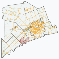
Byron is a neighbourhood in the City of London, Ontario, Canada. It is adjacent to the Thames River in the south-west of London. Almost all of its residents live in low-density, single detached dwellings. As of 2011, the area is home to 15,525 residents. [1] The neighbourhood is considered a high-income area, with an average family income of $130,587 an average dwelling value of $312,896 and a home ownership rate of 93%. [1]

Contents

History

Byron was originally called Westminster, then renamed Hall's Mill, and then finally Byron; named for the poet Lord Byron. [2] The Byron area was settled in 1800 and first became a village in 1804. Up until 1857 the community was known as Hall's Mills, for Charles Hall, post master. [2] On March 7, 1961, it was annexed by the city of London [3] and the population grew substantially with the development of large subdivisions around the original village.

Government and politics

Byron exists within the federal electoral district of London West. It is currently represented by Arielle Kayabaga of the Liberal Party of Canada, first elected in 2021.

Provincially, the area is within the constituency of London West. It is currently represented by Peggy Sattler of the New Democratic Party, first elected in 2013 and re-elected in 2014, 2018, and 2022.

In London's non-partisan municipal politics, Byron lies within ward 9. It is currently represented by Councillor Anna Hopkins, first elected in 2014.

Education

Elementary schools

Byron Somerset Public School Byron Somerset.JPG
Byron Somerset Public School

There are six publicly funded elementary schools in Byron:

Opened in the early 1990s, this school has 337 students in JK to Grade 8. It was built in a former gravel pit, excavated by AAROC Aggregates. Its architecture was by the firm Lamb, Jorden and Jensen, which later became Carsten Jensen.

The first three schools are under the jurisdiction of the Thames Valley District School Board and the latter three are part of the London District Catholic School Board.

Secondary schools

There are no secondary schools located in Byron (a source of some consternation to residents, as a secondary school was originally promised by the city of London when Byron was annexed). Two publicly funded secondary schools serve the needs of Byron students. The nearest is St. Thomas Aquinas Catholic Secondary School in the London District Catholic School Board, to the north across the Thames River. This school primarily serves the needs of Roman Catholic students, though, as it is publicly funded, students of any religious denomination may attend. Most secondary school age students in Byron choose to attend Saunders Secondary School in the Thames Valley District School Board in the Westmount suburb of London. Though they do not live within the drawing area, a number of secondary school age children from Byron currently attend Oakridge Secondary School, located in the neighbourhood of Oakridge in London.

Private schools

There is one private (for profit) school in Byron. This is a Montessori pre-school, located on Commissioners Road between Grand View Ave and Chestnut Hill.

Attractions

Byron is home to Springbank Park, a picturesque urban park and the largest in London. [4] Within Springbank Park is Storybook Gardens, a popular children's attraction open year-round. [5] Byron also has Boler Mountain, a small co-operative that offers skiing, snowboarding, snow-tubing, and mountain bike terrains.

Byron hosted two cycling events during the 2001 Canada Summer Games: the mountain biking event on Boler Mountain, and the road cycling event, where cyclists raced through the heart of the village. [6] [7]

Infrastructure

Byron Telephone Company

Byron was served until August 1960 by the Byron Telephone Company, when it was sold to Bell Canada. A manual telephone exchange continued to operate until September 15, 1963, and in 1962 or 1963, the short code 471 was introduced to London exchange customers for the convenience of immediately reaching the Byron operator to complete a call. Upon dial introduction, 471 became the exchange prefix.

However, some two or three years before 1960, the Byron Telephone Company converted its Lambeth-area customers to a dial exchange, the OLiver 2 exchange.

Location

The current boundaries of Byron are generally regarded to be the land south of the Thames River and west of Colonel Talbot Road. Recent housing developments have expanded Byron southward to Southdale Road and westward to Wickerson Road. Outside of the urban area, Byron is surrounded by farmland and forested areas. On the eastern border of Byron is the Byron Gravel Pit, the sixteenth-largest gravel pit in Canada. Historically, Byron also consisted of some land north of the Thames River in the area known today as Oakridge Park, including the Byron Bog (now Sifton Bog).

Controversy

In 2000, Tim Hortons, which had 44 locations throughout London, sought to open its first full-service location in Byron. At the time, Tim Horton's presence in Byron was limited to a kiosk inside the A&P grocery store with no seating, limited hours, and a limited menu.

Tim Hortons was met by bitter opposition from a small group of members of the community, which had also stopped an entry by Tim Hortons into Byron in 1998. Some members of the group claimed building a Tim Hortons would ruin the "small-town atmosphere," generating too much traffic and noise.

London City Council sided with local residents and refused to rezone a parcel of land along Commissioners Road to permit Tim Hortons to build a store there. TDL Group Ltd. appealed the decision to the Ontario Municipal Board (OMB), which sided with TDL and ordered the city to permit the required rezoning. Tim Hortons opened its Byron location in December 2001.

Notable Byronites

Related Research Articles

<span class="mw-page-title-main">Downsview</span> Neighbourhood in Toronto, Ontario, Canada

Downsview is a neighbourhood in the north end of Toronto, Ontario, Canada, located in the district of North York. The area takes its name from the Downs View farm established around 1842 near the present-day intersection of Keele Street and Wilson Avenue. It now extends beyond the intersection of Sheppard Avenue and Dufferin Street, though it is popularly seen as including the areas to the north right up to the Toronto city limit at Steeles Avenue. The area includes several large post-World War II subdivisions. Within the area is Downsview Airport, the former site of Canadian Forces Base Downsview, which has since been largely converted following the end of the Cold War into an urban park known as Downsview Park. The airport is still used as a manufacturing and testing facility for Bombardier Aerospace. As of the 2021 census, the Downsview-Roding-CFB neighbourhood was split into the two neighbourhoods of Downsview and Oakdale–Beverley Heights.

<span class="mw-page-title-main">Lawrence Heights</span> Neighbourhood in Toronto, Ontario, Canada

Lawrence Heights is a neighbourhood in Toronto, Ontario, Canada. It is located north-west of central Toronto, in the district of North York. The neighbourhood is roughly bounded by Lawrence Avenue to the south, Yorkdale Road to the north, Varna Drive to the east and Dufferin Street to the west. It is part of the greater Yorkdale-Glen Park official Toronto neighbourhood.

<span class="mw-page-title-main">Lambeth, London, Ontario</span> Neighbourhood in London, Ontario, Canada

Lambeth is a neighbourhood in the City of London, Ontario, Canada. It is immediately north of Highway 402, and east of Colonel Talbot Road. Almost all of its residents live in low-density, single detached dwellings. As of 2011, the area is home to 4,410 residents. The neighbourhood is considered a middle to upper-income area, with an average family income of $129,685 an average dwelling value of $340,707 and a home ownership rate of 93%.

The Thames Valley District School Board is a public school board in southwestern Ontario, Canada. It was created on January 1, 1998, by the amalgamation of the Elgin County Board of Education, The Board of Education for the City of London, Middlesex County Board of Education, and Oxford County Board of Education.

<span class="mw-page-title-main">Saunders Secondary School</span> School in London, Ontario, Canada

Saunders Secondary School is a public secondary school located at 941 Viscount Road in the Westmount suburb of London, Ontario, Canada. It is named after William Saunders. William Saunders was a Canadian pioneer and an authority on agriculture and horticulture. Grades offered are 9–12. Saunders' school colours are red and gold and its mascot is a sabre-tooth tiger. Saunders Secondary School is the largest high school in the Thames Valley District School Board with close to 2000 students and 120 teachers. As of 2008, Saunders is also the site of new credit summer school for the TVDSB.

<span class="mw-page-title-main">Lansing, Toronto</span> Neighbourhood in Toronto, Ontario, Canada

Lansing is a neighbourhood in Toronto, Ontario, Canada. It originated as a minor settlement of a store, other services and a post office at the corner of Yonge Street and Sheppard Avenue and later got consolidated with Toronto as sprawling development took place. A larger area was designated as the postal village of Lansing. The City of Toronto labels it as Lansing-Westgate for neighbourhood planning purposes with the boundaries Yonge Street to the east, Highway 401 to the south, Bathurst Street to the west and Burnett Avenue to the north.

<span class="mw-page-title-main">Thames River (Ontario)</span> River in Ontario, Canada

The Thames River is located in southwestern Ontario, Canada.

<span class="mw-page-title-main">Victoria Village</span> Neighbourhood in Toronto, Ontario, Canada

For the settlement established by former slaves in Guyana known as Victoria Village see Victoria, Guyana

<span class="mw-page-title-main">Rockcliffe–Smythe</span> Neighbourhood in Toronto, Ontario, Canada

Rockcliffe–Smythe is a neighbourhood in Toronto, Ontario, Canada. It was developed after World War II as part of the urbanization of the former suburb of York Township. It is in Ward 5 in the City of Toronto.

<span class="mw-page-title-main">Clairlea</span> Neighbourhood in Toronto, Ontario, Canada

Clairlea is a safe, quiet, middle to upper-middle income neighbourhood in Toronto, Ontario, Canada that features well treed streets and detached homes with large backyards. The neighbourhood is located in east Toronto just east of Victoria Park Avenue.

<span class="mw-page-title-main">Rouge, Toronto</span> Neighbourhood in Toronto, Ontario, Canada

Rouge is a neighbourhood in the northeastern area of Toronto, Ontario, within the former city of Scarborough. It is Toronto's largest neighbourhood by surface area; however, unlike other neighbourhoods, most of its area remains undeveloped, as the neighbourhood is adjacent to Rouge National Urban Park.

<span class="mw-page-title-main">Oakridge Acres</span> Neighbourhood in London, Ontario, Canada

Oakridge Acres is a neighbourhood in north-west of the City of London, Ontario, Canada. It is north of Westmount and north-east of Byron. The neighbourhood comprises the subdivisions of Oakridge Acres, Oakridge Park, Oakridge Meadows, Thornwood Estates, Hunt Club Green, Hazelden, and Hazelden Park. Almost all of its residents live in low-density, single detached dwellings. As of 2011, the area is home to 16,730 residents. The neighbourhood is considered a middle to upper-income area, with an average family income of $124,966 an average dwelling value of $319,726 and a home ownership rate of 89%.

Byron Northview Public School is an elementary school in the community of Byron in London, Ontario, Canada and part of the Thames Valley District School Board. Byron Northview is a JK-8 school with a long tradition of educating young people. The present building sits on the oldest site of a school location in southern Ontario. In 1987, the school celebrated the 150th Anniversary of the Byron Northview School site. Former students came from as far away as Australia and Africa to celebrate this significant event. Each year at the Graduation Ceremony, two deserving students are awarded cash prizes from a special fund established to recognize the anniversary.

<span class="mw-page-title-main">Wonderland Road</span>

Wonderland Road is a major north-south arterial road in London, Ontario, designated as Ontario Highway 4 between Highway 401 and Sunningdale Road. Outside of the City limits, the road extends north into Middlesex Centre as Middlesex County Road 56 and south into Southwold. It is one of the busiest roads in London, carrying over 43,000 vehicles per day between Springbank Drive and Riverside Drive as of 2013.

<span class="mw-page-title-main">St. Thomas Aquinas Catholic Secondary School (London, Ontario)</span> Roman catholic school in London, Ontario, Canada

St. Thomas Aquinas Catholic Secondary School (STA) is a Catholic secondary school in London, Ontario, located in the neighbourhood of Oakridge in the west end of the city. It currently serves students in the London District Catholic School Board in the London Areas of Byron, Oakridge, Westmount, Lambeth, as well as some areas outside of the city limits such as Delaware, Komoka and even as far as Mount Brydges.

<span class="mw-page-title-main">Oakridge Secondary School</span> Secondary, government-operated/public school in London, Ontario, Canada

Oakridge Secondary School is one of the government-operated high schools in the neighbourhood of Oakridge in London, Ontario, Canada. The school enrolls around 1000 students, and is located on Oxford Street in West London. The school's demonym is Oakridge Oaks and its colours are red, blue and gold.

<span class="mw-page-title-main">Birch Cliff</span> Neighbourhood in Toronto, Ontario, Canada

Birch Cliff is a neighbourhood in Toronto, Ontario, Canada. It is located in the eastern part of the city, part of the district of Scarborough running along the shore of Lake Ontario atop the western part of the Scarborough Bluffs. Birch Cliff has a large Irish population. About one-third of Birch Cliff residents are of Irish origin.

Huron Heights is a neighbourhood in the City of London, Ontario, Canada. Located in the northeast part of the city, development began around 1960 and continued to the late 1960s in four distinct phases, and included three public elementary schools, and provided students to one Catholic elementary in the area and one public secondary school just northwest of the development. A large commercial plaza with anchor grocery and department stores was developed at the west edge, and a neighbourhood plaza was developed in the central part. A city arena was built and later supplemented with a public swimming pool.

References

  1. 1 2 "Byron". Neighbourhood Profiles. City of London – Planning Division. 2022. Retrieved 2022-01-07.
  2. 1 2 Hamilton, William (1978). The Macmillan Book of Canadian Place Names. Toronto: Macmillan. p. 139. ISBN   0-7715-9754-1.
  3. Grainger, Jennifer (2002). Vanished Villages of Middlesex. Dundurn Press. p. 293. ISBN   978-1-896219-51-6 . Retrieved 2009-01-27.
  4. D'Oria, Lina (February 25, 2016). "Special Event Location Guide" (PDF). www.london.ca. City of London. Retrieved 25 April 2016.
  5. "Parks and Recreation Strategic Master Plan" (PDF). City of London. 2011. p. 13. Retrieved 25 April 2016.
  6. "2001 Canada Summer Games in London". www.canadagames.ca. Canada Games. Retrieved 25 April 2016.
  7. "2000 Springbank Road Races". www.canadiancyclist.com. Canadian Cyclist. Retrieved 25 April 2016.
  8. Lumley, Elizabeth, ed. (2004). "Calhoun, Ronald George". Canadian Who's Who 2004. Toronto: University of Toronto Press. p. 198. ISBN   978-0-8020-8892-5 . Retrieved 4 September 2010.
  9. Fischler, Stan (2003). Who's Who in Hockey. Andrews McMeel Publishing. p. 344. ISBN   978-0-7407-1904-2 . Retrieved 2009-01-27.
  10. "Rob Ramage found guilty of 5 charges". CBC News. 2007-10-11.