
A satellite navigation or satnav system is a system that uses satellites to provide autonomous geopositioning. A satellite navigation system with global coverage is termed global navigation satellite system (GNSS). As of 2024, four global systems are operational: the United States's Global Positioning System (GPS), Russia's Global Navigation Satellite System (GLONASS), China's BeiDou Navigation Satellite System (BDS), and the European Union's Galileo.

FalconSAT is the United States Air Force Academy's (USAFA) small satellite engineering program. Satellites are designed, built, tested, and operated by Academy cadets. The project is administered by the USAFA Space Systems Research Center under the direction of the Department of Astronautics. Most of the cadets who work on the project are pursuing a bachelor of science degree in astronautical engineering, although students from other disciplines join the project.

Radio occultation (RO) is a remote sensing technique used for measuring the physical properties of a planetary atmosphere or ring system. Satellites carrying onboard GNSS-Radio occultation instruments include CHAMP, GRACE and GRACE-FO, MetOp and the recently launched COSMIC-2.

In 2015, the maiden spaceflights of the Chinese Long March 6 and Long March 11 launch vehicles took place.

Several new rockets and spaceports began operations in 2016.

This article documents notable spaceflight events during the year 2019.

Notable spaceflight activities in 2017 included the maiden orbital flight of India's Geosynchronous Satellite Launch Vehicle Mark III on 5 June and the first suborbital test of Rocket Lab's Electron rocket, inaugurating the Mahia spaceport in New Zealand. The rocket is named for its innovative Rutherford engine which feeds propellants via battery-powered electric motors instead of the usual gas generator and turbopumps.

This article documents notable spaceflight events during the year 2018. For the first time since 1990, more than 100 orbital launches were performed globally.
Technology Education Satellite (TechEdSat) is a successful nano-sat flight series conducted from the NASA Ames Research Center in collaboration with numerous universities. While one of the principal aims has been to introduce young professionals and university students to the practical realm of developing space flight hardware, considerable innovations have been introduced. In addition, this evolving flight platform has tested concepts for Low Earth Orbit (LEO) sample return, as well as planetary nano-sat class mission concepts.

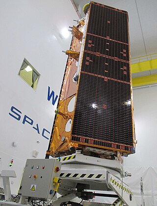
AsiaSat 6 / Thaicom 7 is a geostationary communications satellite which is operated by the Asia Satellite Telecommunications Company (AsiaSat) and was launched into orbit on 7 September 2014. The satellite project was developed in cooperation between satellite operators AsiaSat and Thaicom. AsiaSat owns half of the satellite's 28 transponders which are marketed as AsiaSat 6. The other half of the satellite is owned by Thaicom and is marketed as Thaicom 7. AsiaSat's part of the satellite is operated under license of the China (PRC), whereas Thaicom's part is operated under license of Thailand.
Space Tethered Autonomous Robotic Satellite II or STARS-II, was a nanosatellite built by Japan's Kagawa University to test an electrodynamic tether in low Earth orbit, a follow-on to the STARS mission.

COSMIC-2 also known as FORMOSAT-7, is the constellation of satellites for meteorology, ionosphere, climatology, and space weather research. FORMOSAT-7 is a joint US-Taiwanese project including National Space Organization (NSPO) on the Taiwanese side and the National Oceanic and Atmospheric Administration (NOAA) and the United States Air Force (USAF) on the US side. FORMOSAT-7 is the successor of FORMOSAT-3 The six satellites of the constellation were launched 25 June 2019 on a Falcon Heavy rocket. They reached their designated mission orbits in February 2021, after eighteen months of gradual orbital adjustments. Full operational capability was achieved in October 2021.
Spire Global, Inc. is a space-to-cloud data and analytics company that specializes in the tracking of global data sets powered by a large constellation of nanosatellites, such as the tracking of maritime, aviation and weather patterns.
Paz is a Spanish Earth observation and reconnaissance satellite launched on 22 February 2018. It is Spain's first spy satellite. The satellite is operated by Hisdesat. Paz was previously referred to as SEOSAR.
Fox-1E, AO-109 or AMSAT OSCAR 109 is an American amateur radio satellite. It is a 1U Cubesat, was built by the AMSAT-NA and carries a 30KHz linear transponder radio. Fox-1E is the fifth amateur radio satellite of the Fox series of AMSAT North America.
SatRev S.A. is a Polish aerospace company established in 2016, that specialises in building small, lightweight, nanosatellites. The company was listed in the NASA's "State of the Art Small Spacecraft Technology" report as one of 12 in the world.
Yunhai-3 is the third set of satellites in a series of Chinese meteorological satellites developed by the Chinese military. The satellites are built by the China Aerospace Science and Technology Corporation (CASC) and then transported to Taiyuan for launch. Their main uses are in the fields of atmospheric data for weather prediction, ionosphere, gravity and climate research, as well as disaster prevention. Like the Yunhai-2 series, the satellites reportedly use the Global Navigation Satellite System Radio Occultation (GNSS-RO).
