Route information | ||||
---|---|---|---|---|
Maintained by Caltrans | ||||
Length | 49.651 mi [1] (79.906 km) | |||
History | State highway in 1910 and 1933; became SR 24 in the 1930s and SR 160 in 1964 | |||
Tourist routes | River Road between the Contra Costa–Sacramento county line and the City of Sacramento [2] | |||
Section 1 | ||||
South end | SR 4 in Antioch | |||
Major intersections | SR 12 near Rio Vista CR J11 in Walnut Grove CR E9 near Paintersville | |||
North end | Freeport Boulevard at Sacramento south city limit | |||
Section 2 | ||||
South end | 16th Street Bridge over the American River | |||
North end | I-80 BL in Sacramento | |||
Location | ||||
Country | United States | |||
State | California | |||
Counties | Contra Costa, Sacramento | |||
Highway system | ||||
|
State Route 160 (SR 160) is a state highway in the U.S. state of California consisting of two sections. The longer, southern, section is a scenic highway through the alluvial plain of the Sacramento River, linking SR 4 in Antioch with Sacramento via the Antioch Bridge. The northern section, separated from the southern by Sacramento city streets, is the North Sacramento Freeway, running from the 16th Street Bridge over the American River to Interstate 80 Business towards Roseville.
This northern section was deleted from the definition in the Streets and Highways Code in 2003, when the relinquished portion through downtown Sacramento was also removed, but it is still maintained and signed by the California Department of Transportation (Caltrans) as SR 160.
State Route 160 begins in eastern Antioch at SR 4 as a four-lane freeway. After two interchanges, the highway becomes a two-lane expressway and rises onto the Antioch Bridge over the San Joaquin River. It cuts north across the center of Sherman Island as a two-lane surface road, reaching the Sacramento River on the opposite shore. From here to Sacramento, SR 160 never strays far from the river, first following the east levee over the 1949 [3] Three Mile Slough Bridge (a lift bridge), past Brannan Island State Recreation Area, and across SR 12 opposite the river from Rio Vista. After passing Isleton, the highway crosses the river on the Isleton Bridge, a bascule bridge built in 1923, [3] and runs along the west shore on Grand Island, where it meets the east end of SR 220. The Walnut Grove Bridge carries County Route J11 east across the river to Walnut Grove, and, at the north end of the island, SR 160 crosses the 1924 [3] Steamboat Slough Bridge onto Sutter Island and then the 1923 [3] Paintersville Bridge across the Sacramento River to the mainland, both bascule bridges. [4]
On the mainland, SR 160 once again runs atop the east levee, now 1–2 miles (1.5–3 km) west of Interstate 5. The final bridge over the river is the Freeport Bridge, which carries County Route E9 to the west levee, where it turns south to return to SR 160 at the west end of the Paintersville Bridge. About a mile (1.5 km) beyond the Freeport Bridge, SR 160 leaves the levee, enters the city of Sacramento (where state maintenance and control ends), passes under I-5, and farms give way to suburbs. Here the former SR 160 is known as Freeport Boulevard, a major surface road that passes the Sacramento Executive Airport and Sacramento City College. Freeport Boulevard turns to the northwest at about 4th Avenue. It was formerly a one-way pair with 21st Street with Freeport heading one-way southbound and 21st heading one-way northbound. The city converted these streets back to two-way streets for traffic calming purposes in 2008. [5] After a short jog west on Broadway, former SR 160 turns north on the one-way pair of 15th (southbound) and 16th (northbound) Streets, almost immediately crossing Business 80 and entering downtown Sacramento. [4]
15th and 16th Streets lead traffic north past the east side of the State Capitol grounds, which lie between L and N Streets. At F Street, the path of southbound SR 160 jogged west for three blocks to 12th Street; both 12th and 16th Streets pass under the Union Pacific Railroad's Martinez Subdivision (where B Street would be) in four-lane subways, but 15th Street dead-ends. 12th Street remains a one-way southbound roadway, but the two-way SacRT light rail now occupies its east side. 12th Street turns northeast at North B Street, and the two directions of former SR 160 come together at Richards Boulevard, just south of the 16th Street Bridge over the American River and the south end of the state-maintained North Sacramento Freeway. The light rail, which crosses the river between the two directions of SR 160, soon leaves at the Del Paso Boulevard interchange as the freeway turns east. Two folded diamonds at local streets and a northbound-only entrance ramp from Tribute Road are all that remains before SR 160 merges with Business 80 at the Arden Way interchange. Business 80 is also known as the Capital City Freeway here. [4]
The northern portion is also part of the California Freeway and Expressway System, as is the piece south of SR 12 near Rio Vista, [6] though, of the latter, only the southernmost piece in Antioch is built to freeway standards. The northern piece and the southern piece south of SR 12 are also part of the National Highway System, [7] a network of highways that are considered essential to the country's economy, defense, and mobility by the Federal Highway Administration. [8] The entire southern portion, from SR 4 to Sacramento, is eligible to be included in the State Scenic Highway System, [9] and is officially designated as a scenic highway by the California Department of Transportation, [10] meaning that it is a substantial section of highway passing through a "memorable landscape" with no "visual intrusions", where the potential designation has gained popular favor with the community. [11]
In the late 1910s, Sacramento County improved the county road along the levee of the Sacramento River between Sacramento and Rio Vista, which crossed the river twice on free ferries near Paintersville and Isleton. [12] A toll ferry across the San Joaquin River connected Sherman Island, south of Rio Vista, with Antioch, where drivers could head west through the Broadway Tunnel to reach the San Francisco Bay, but the road between Rio Vista and the ferry was poor. [13] [14] In 1922, the Victory Highway Association selected this "Netherlands Route" (through what was locally promoted as the "Netherlands of America") for the Victory Highway west of Sacramento, as it was both shorter than the Lincoln Highway route via Stockton and more scenic. In particular, the river district would "impress [the motorist] with the enormous productive resources of this state as well as supply him with an unmatched scenic drive", and the Broadway Tunnel approach to the bay would bring him "over the Victory Highway to the end of his journey in such a fashion that he will never forget the view spread before him as he first comes into sight of the San Francisco Bay region". [15]
Two bascule bridges—the Paintersville Bridge and Isleton Bridge—replaced the free ferries in 1923, and are of a type patented by Joseph B. Strauss, who went on to design the Golden Gate Bridge. [16] [17] Local businessmen Aven Hanford and Oscar Klatt replaced the toll ferry with the tolled Antioch Bridge in mid-1926, [18] [19] almost a year before they opened the larger Carquinez Bridge to the west. [20] The counties of Contra Costa and Sacramento organized a joint highway district in November 1925 to fund an improvement of the northern approach from Rio Vista; [21] the concrete highway was completed in July 1927, creating a fully paved continuous route between Sacramento and the bay. [22]
The legislature added this road to the state highway system in 1933, and it became part of Legislative Route 11, which had stretched east from Sacramento along US 50. [23] [24] This part of Route 11 was not assigned a sign route number in 1934, [25] but, by 1937, when the new Broadway Low Level Tunnel opened, it was part of Sign Route 24. That route had initially begun at Woodland and traveled northeast and east through the Feather River Canyon, and was extended southeast from Woodland along Sign Route 16 to Sacramento and then south and west via Antioch to the San Francisco – Oakland Bay Bridge approach in Berkeley. [26] [27] The California Freeway and Expressway System was formed in 1959, and included in the planned upgrades was the road between Antioch and Rio Vista. (North of Rio Vista the present SR 84 was part of the system.) [28] The entire length was included in the State Scenic Highway System in 1963. [29] In the 1964 renumbering, the Antioch-Sacramento roadway was split between two routes: Route 84 from Antioch to SR 12 near Rio Vista, and Route 160 from SR 12 to Sacramento. [30] However, the entire route was marked as SR 160, [31] and in 1981 the legislative definition was changed to reflect this. [32]
The part of SR 160 through and north of downtown Sacramento began as part of Legislative Route 3, which was added to the state highway system under the first bond issue, passed in 1910, [33] and left the city on the 16th Street Bridge over the American River, following Del Paso Boulevard, El Camino Avenue, and Auburn Boulevard to Roseville. [12] [34] (The short piece from the end of Route 3 near the State Capitol south to Broadway and Freeport Boulevard was Route 4, which followed SR 99 towards Los Angeles. [35] ) Route 3 between Sacramento and Roseville was also part of the Victory Highway, and was marked as part of US 40 in 1928 [36] and US 99E in 1929. [37] The North Sacramento Freeway opened on October 6, 1947, bypassing this route from the bridge to Auburn Boulevard near Ben Ali. [38] In 1955, the Elvas Freeway opened from the midpoint of the North Sacramento Freeway to the east side of downtown, [39] and US 99E was moved off the south half of the older North Sacramento Freeway and onto the Elvas Freeway. [35] The North Sacramento Freeway was included in the California Freeway and Expressway System when it was created in 1959, [40] and the part of Route 3 southwest of the Elvas Freeway, which carried I-80, became part of SR 160 in the 1964 renumbering. [30]
By 2000, the city of Sacramento maintained the non-freeway portion of SR 160 within the city limits under a contract with Caltrans. However, since Caltrans's main goal is to move traffic efficiently, the city was not able to carry out pedestrian-friendly projects that they and local residents wanted. Under a law passed in July 1999, Caltrans was authorized to relinquish any part of Route 160 within the city limits to Sacramento. [41] [42] The two agencies agreed, and on October 19, 2000, the portion from the south city limits to the American River became the full responsibility of the city. [43] A 2003 amendment to the Streets and Highways Code erroneously deleted not only this part, but the North Sacramento Freeway as well. [44]
A project to convert the former southbound-only Richards Boulevard access just south of the American River to a standard signalized intersection was completed in August 2007; this improves access to existing and future development in the area, including redevelopment of a former rail yard, [45] while slowing northbound traffic heading for the bridge and freeway. [43] Another project converting Freeport Boulevard and 21st Street south of Broadway into two-way streets was also completed. 21st Street has carried northbound traffic since 1974, when Caltrans took it over. This will calm traffic while improving the intersection at the south end of the former one-way pair, which the SacRT light rail now crosses 21st Street just to the north of. [46] [47] In addition, the three blocks of F Street that carried southbound SR 160 from 12th Street to 15th Street have been calmed by the addition of a roundabout at 13th Street. [4]
In 2012, SR 4 was re-routed to go further south to bypass Oakley and Brentwood. The southern end of SR 160 was then extended south to cover the part of the freeway that is no longer designated as SR 4, from Main Street (where State Route 4 originally exited the freeway) to the fork of the new SR 4 (formerly known as the State Route 4 Bypass, or Bypass Road).
In 2014, construction began at the interchange with SR 4 to complete the two remaining ramps that would link southbound SR 160 to eastbound SR 4 and westbound SR 4 to northbound SR 160. Construction was completed in March 2016. [48]
Except where prefixed with a letter, postmiles were measured on the road as it was in 1964, based on the alignment as it (and State Route 84 south of State Route 12) existed at that time, and do not necessarily reflect current mileage. R reflects a realignment in the route since then, M indicates a second realignment, L refers to an overlap due to a correction or change, and T indicates postmiles classified as temporary ( ). [1] Segments that remain unconstructed or have been relinquished to local control may be omitted. The numbers reset at county lines; the start and end postmiles in each county are given in the county column.
County | Location | Postmile [1] [3] [49] | Exit [50] | Destinations | Notes | ||
---|---|---|---|---|---|---|---|
Contra Costa CC L0.00-1.33 | Antioch | L0.00 | — | SR 4 east – Stockton | Southern end of SR 160; SR 4 exit 30 | ||
— | SR 4 west – Martinez, Oakland | ||||||
0.00 | 1A | Main Street, East 18th Street – Downtown Oakley | Former exit 1B southbound; former SR 4 east | ||||
0.49 | 1B | Wilbur Avenue | Former exits 1 northbound and 1C southbound | ||||
| Northern end of freeway | ||||||
San Joaquin River | 1.33– L0.00 | Antioch Bridge (northbound toll only) | |||||
Sacramento SAC L0.00-47.05 | | L6.98 | Three Mile Slough Bridge over Three Mile Slough | ||||
| L10.78 0.00 | SR 12 – Lodi, Rio Vista | |||||
| 5.95 | Isleton Bridge over Sacramento River | |||||
Ryde | 11.46 | SR 220 – Hogback Island | Eastern terminus of SR 220 | ||||
Walnut Grove | 14.16 | CR J11 (Walnut Grove Bridge) – Locke, Thornton, Stockton | Western terminus of CR J11 | ||||
| 19.76 | Steamboat Slough Bridge over Steamboat Slough | |||||
| 20.87 | CR E9 (Sutter Slough Bridge Road) | Southern terminus of CR E9 | ||||
| 20.98 | Paintersville Bridge over Sacramento River | |||||
| 34.07 | Freeport Bridge (CR E9) – Clarksburg | Northern terminus of CR E9 | ||||
Sacramento | 35.05 | North end of southern segment of SR 160 at Sacramento south city limit | |||||
Freeport Boulevard | Continuation beyond the Sacramento city limits; former SR 24 / SR 160 north; access to I-5 is via Pocket Road | ||||||
Gap in route | |||||||
R44.37 | North 12th Street | Continuation beyond Richards Boulevard; former US 40 west / SR 160 south | |||||
R44.37 | Richards Boulevard | ||||||
R44.46 | South end of northern segment of SR 160 Southern end of freeway | ||||||
16th Street Bridge over American River | |||||||
R44.62 | 46A | Northgate Boulevard | Northbound exit and southbound entrance | ||||
R44.98 | 46B | Del Paso Boulevard | Northbound left exit and southbound entrance; former US 40 east | ||||
45.60 | 47A | Leisure Lane, Canterbury Road | |||||
46.16 | 47B | Exposition Boulevard, Royal Oaks Drive | Exposition Boulevard not signed southbound | ||||
46.33 | — | Tribute Road | Northbound entrance only; serves traffic from Exposition Boulevard to I-80 BL east because there is no direct ramp | ||||
46.58 | 48 | Arden Way | Northbound exit and southbound entrance | ||||
47.05 | — | I-80 BL east (Capital City Freeway) – Reno | Northbound exit and southbound entrance; no access to I‑80 BL west; former US 99E north / I-80 east; north end of SR 160; I‑80 BL west exit 9B | ||||
1.000 mi = 1.609 km; 1.000 km = 0.621 mi |
State Route 1 (SR 1) is a major north–south state highway that runs along most of the Pacific coastline of the U.S. state of California. At 656 miles (1,056 km), it is the longest state route in California, and the second-longest in the US after Montana Highway 200. SR 1 has several portions designated as either Pacific Coast Highway (PCH), Cabrillo Highway, Shoreline Highway, or Coast Highway. Its southern terminus is at Interstate 5 (I-5) near Dana Point in Orange County and its northern terminus is at U.S. Route 101 (US 101) near Leggett in Mendocino County. SR 1 also at times runs concurrently with US 101, most notably through a 54-mile (87 km) stretch in Ventura and Santa Barbara counties, and across the Golden Gate Bridge.
Interstate 680 (I-680) is a north–south auxiliary Interstate Highway in Northern California. It curves around the eastern cities of the San Francisco Bay Area from San Jose to I-80 at Fairfield, bypassing cities along the eastern shore of San Francisco Bay such as Oakland and Richmond while serving others more inland such as Pleasanton and Concord.
Route 110, consisting of State Route 110 (SR 110) and Interstate 110 (I-110), is a state and auxiliary Interstate Highway in the Los Angeles metropolitan area of the US state of California. The entire route connects San Pedro and the Port of Los Angeles with Downtown Los Angeles and Pasadena. The southern segment from San Pedro to I-10 in downtown Los Angeles is signed as I-110, while the northern segment to Pasadena is signed as SR 110. The entire length of I-110, as well as SR 110 south of the Four Level Interchange with US Route 101 (US 101), is the Harbor Freeway, and SR 110 north from US 101 to Pasadena is the historic Arroyo Seco Parkway, the first freeway in the western United States.
State Route 57 (SR 57), also known as the Orange Freeway for most of its length, is a north–south state highway in the Greater Los Angeles Area of the U.S. state of California. It connects the interchange of Interstate 5 (I-5) and SR 22 near downtown Orange, locally known as the Orange Crush, to the Glendora Curve interchange with I-210 and SR 210 in Glendora. The highway provides a route across several spurs of the Peninsular Ranges, linking the Los Angeles Basin with the Pomona Valley and San Gabriel Valley.
State Route 24 is a heavily traveled east–west state highway in the U.S. state of California that serves the eastern side of the San Francisco Bay Area. A freeway throughout its entire length, it runs from the Interstate 580/Interstate 980 interchange in Oakland, and through the Caldecott Tunnel under the Berkeley Hills, to the Interstate 680 junction in Walnut Creek. It lies in Alameda County, where it is highly urban, and Contra Costa County, where it passes through wooded hillsides and suburbs. SR 24 is a major connection between the San Francisco–Oakland Bay Bridge/MacArthur Maze complex and the inland cities of the East Bay.
State Route 38 is a mostly rural and scenic state highway in the U.S. state of California, connecting Interstate 10 in Redlands with State Route 18 in the Big Bear Lake area. It is one of the primary routes into the San Bernardino Mountains. Despite the orientation of its alignment, SR 38 is assigned in a west–east direction.
State Route 84 is a state highway in the U.S. state of California that consists of two unconnected segments, one in the San Francisco Bay Area and the other primarily in the Sacramento–San Joaquin River Delta area.
State Route 3 is a state highway in the U.S. state of California that serves Trinity and Siskiyou counties. It runs from SR 36 north along the shore of Trinity Lake, Fort Jones and Etna. The route then approaches Yreka, intersecting with Interstate 5 (I-5), and turns east to Montague. The road was numbered SR 3 in 1964, and most of it has been part of the state highway system since 1933.
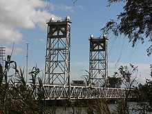
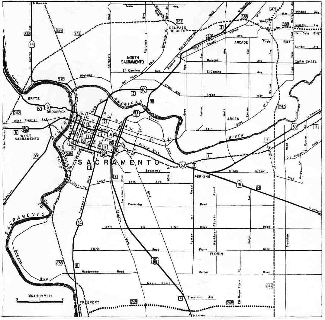
State Route 275 is an unsigned state highway connecting West Sacramento, California and Downtown Sacramento. Since 1996, the highway has been legally defined to be the length of the Tower Bridge crossing the Sacramento River. Prior to that year, SR 275 was also known as the West Sacramento Freeway, and was a short spur connecting Interstate 80 Business / U.S. Route 50 in West Sacramento, and the Tower Bridge. SR 275 also extended east into Sacramento along the Capitol Mall from the bridge to 9th Street, just west of the California State Capitol. West Sacramento completed a project to replace the freeway with a pedestrian-friendly street initially named Tower Bridge Gateway. The street was renamed Cabaldon Parkway in honor of former West Sacramento mayor Christopher Cabaldon.
State Route 16 is a state highway in the northern region of the U.S. state of California that runs from Route 20 in Colusa County to Route 49 just outside Plymouth in Amador County, primarily crossing the Sacramento Valley. Much of the route through the Sacramento area is unsigned as it runs on a concurrency with the I-5 and US 50 freeways.
State Route 12 is a state highway in the U.S. state of California that travels in an east–west direction from State Route 116 in Sebastopol in Sonoma County to State Route 49 just north of San Andreas in Calaveras County. The route connects the Sonoma and Napa valleys with the Sacramento–San Joaquin River Delta and the Sierra Foothills. It is constructed to freeway standards from the Fulton Road/South Wright Road stoplight in Santa Rosa, to its partial interchange with Farmers Lane.
State Route 4 is a state highway in the U.S. state of California, routed from Interstate 80 in the San Francisco Bay Area to State Route 89 in the Sierra Nevada. It roughly parallels the Sacramento-San Joaquin River Delta, a popular area for boating and fishing, with a number of accesses to marinas and other attractions. After crossing the Central Valley, the highway ascends up the Sierra foothills. It passes through Ebbetts Pass and contains the Ebbetts Pass Scenic Byway, a National Scenic Byway.
State Route 27, commonly known by its street name Topanga Canyon Boulevard, is a state highway in the U.S. state of California that runs from the Pacific Coast Highway at Topanga State Beach near Pacific Palisades, through the Topanga Canyon in Topanga, and continuing through Woodland Hills, Canoga Park, West Hills, and Chatsworth to the Ronald Reagan Freeway.
State Route 54 (SR 54) is a state highway in the U.S. state of California that consists of two segments in San Diego County. The westernmost part of the highway is known as the South Bay Freeway, beginning at Interstate 5 (I-5) in National City and running along the Sweetwater River before ending at the intersection with SR 125 and Jamacha Boulevard near Spring Valley. SR 54 then resumes at SR 94 in Rancho San Diego as an undivided highway that leads to the city limits of El Cajon. County Route S17 (CR S17) connects the two portions of the highway; the center portion of SR 54 was never constructed.
State Route 62 is a state highway in the U.S. state of California that cuts across the Little San Bernardino Mountains in Riverside and San Bernardino counties. Its western terminus is at Interstate 10 in unincorporated Riverside County outside the borders of Whitewater and Palm Springs. Its eastern terminus is at the Arizona state line just east of Parker, Arizona. The highway passes through the city of Twentynine Palms and along the northern boundary of the Joshua Tree National Park.
State Route 70 is a state highway in the U.S. state of California, connecting SR 99 north of Sacramento with U.S. Route 395 near Beckwourth Pass via the Feather River Canyon. Through the Feather River Canyon, from SR 149 to US 395, SR 70 is the Feather River Scenic Byway, a Forest Service Byway that parallels the ex-Western Pacific Railroad's Feather River Route.
State Route 244 is an unsigned state highway in the U.S. state of California located northeast of Sacramento. It serves as a short freeway connection between the Interstate 80/Interstate 80 Business junction and Auburn Boulevard. SR 244 was first added to the state highway system in 1959 as Legislative Route 288, and was renumbered as SR 244 in the 1964 renumbering. Portions of this route have been removed from the system as recently as 1994.
State Route 174 is a state highway in the U.S. state of California. The two-lane 13-mile (21 km) highway in the western Sierra Nevada, added to the state highway system in 1933, connects Interstate 80 in Colfax with SR 20/SR 49 in Grass Valley, crossing the Bear River next to a 1924 concrete arch bridge. The majority of the route is eligible for the State Scenic Highway System, but local residents have blocked its designation due to property right concerns.
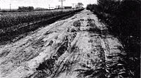
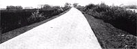
U.S. Route 50 (US 50) is a transcontinental United States Numbered Highway, stretching from West Sacramento, California, in the west to Ocean City, Maryland, in the east. The California portion of US 50 runs east from Interstate 80 (I-80) in West Sacramento to the Nevada state line in South Lake Tahoe. A portion in Sacramento also has the unsigned designation of Interstate 305. The western half of the highway in California is a four-or-more-lane divided highway, mostly built to freeway standards, and known as the El Dorado Freeway outside of downtown Sacramento. US 50 continues as an undivided highway with one eastbound lane and two westbound lanes until the route reaches the canyon of the South Fork American River at Riverton. The remainder of the highway, which climbs along and out of the canyon, then over the Sierra Nevada at Echo Summit and into the Lake Tahoe Basin, is primarily a two-lane road.
U.S. Route 95 (US 95) is a United States Numbered Highway, stretching from the Mexican border in San Luis, Arizona to the Canadian border near Eastport, Idaho. The California portion of US 95 traverses through the far eastern edges of both Riverside and San Bernardino counties. US 95 serves Blythe and Needles and junctions with SR 62 at Vidal Junction.