State Highway 6 runs from the Red River, the Texas–Oklahoma boundary, to northwest of Galveston, where it is known as the Old Galveston Highway. In Sugar Land and Missouri City, it is known as Alvin-Sugarland Road and runs perpendicular to I-69/US 59. In the Houston area, it runs north to FM 1960, then northwest along US Highway 290 to Hempstead, and south to Westheimer Road and Addicks, and is known as Addicks Satsuma Road. In the Bryan–College Station area, it is known as the Earl Rudder Freeway. In Hearne, it is known as Market Street. In Calvert, it is known as Main Street. For most of its length, SH 6 is not a limited-access road.

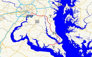
Maryland Route 2 is the longest state highway in the U.S. state of Maryland. The 79.24-mile (127.52 km) route runs from Solomons Island in Calvert County north to an intersection with U.S. Route 1 /US 40 Truck in Baltimore. The route runs concurrent with MD 4 through much of Calvert County along a four-lane divided highway known as Solomons Island Road, passing through rural areas as well as the communities of Lusby, Port Republic, Prince Frederick, and Huntingtown. In Sunderland, MD 2 splits from MD 4 and continues north as two-lane undivided Solomons Island Road into Anne Arundel County, still passing through rural areas. Upon reaching Annapolis, the route runs concurrent with US 50/US 301 around the city. Between Annapolis and Baltimore, MD 2 runs along the Governor Ritchie Highway, a multilane divided highway that heads through suburban areas, passing through Arnold, Severna Park, Pasadena, Glen Burnie, and Brooklyn Park. In Baltimore, the route heads north on city streets and passes through the downtown area of the city.
Maryland Route 4 is a state highway in the U.S. state of Maryland. The highway runs 64.85 miles (104.37 km) from MD 5 in Leonardtown north to Southern Avenue in Suitland at the District of Columbia boundary, beyond which the highway continues into Washington as Pennsylvania Avenue. MD 4 is a four- to six-lane highway that connects Washington and communities around Interstate 95 (I-95)/I-495 with southern Prince George's County with southwestern Anne Arundel County. The highway is the primary highway for the length of Calvert County, during most of which the route runs concurrently with MD 2. MD 4 also connects Calvert and St. Mary's counties via the Governor Thomas Johnson Bridge across the Patuxent River. The highway connects the Southern Maryland county seats of Leonardtown, Prince Frederick, and Upper Marlboro.
Maryland Route 274 is a state highway in the U.S. state of Maryland. Known for most of its length as Joseph Biggs Memorial Highway, the state highway runs 7.35 miles (11.83 km) from MD 273 in Rising Sun east to MD 272 in Bay View. In conjunction with MD 272, MD 274 connects Rising Sun with Interstate 95 (I-95) in central Cecil County. The highway was built near Rising Sun in two segments, one before 1910 and the other in the mid-1920s. MD 274 was completed to Bay View in the early 1940s. The highway was relocated at Bay View in the late 1960s and reconstructed the rest of the way to Rising Sun in the late 1970s and early 1980s. MD 274 had a truck bypass using MD 273 and MD 272 via Calvert.

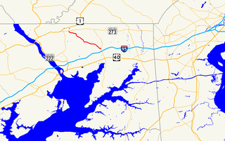
Maryland Route 273 is a state highway in the U.S. state of Maryland. Known for most of its length as Telegraph Road, the highway runs 16.58 miles (26.68 km) from U.S. Route 1 near Harrisville east to the Delaware state line near Appleton, where the highway continues east as Delaware Route 273. MD 273 is the main east–west highway of northern Cecil County, connecting Conowingo, Port Deposit, and Rising Sun with Newark, Delaware, via the communities of Calvert and Fair Hill, where the highway intersects MD 272 and MD 213, respectively. The state highway also provides access to the Fair Hill Training Center.

Maryland Route 272 is a state highway in the U.S. state of Maryland. The state highway runs 20.67 miles (33.27 km) from Turkey Point within Elk Neck State Park north through North East to the Pennsylvania state line near Calvert, where the highway continues as Pennsylvania Route 272. MD 272 is the main north–south highway of central Cecil County, connecting the Elk Neck Peninsula between the North East River and Elk River with U.S. Route 40 and Interstate 95 (I-95) in North East, MD 273 in Calvert, and Rising Sun via MD 274. The section of MD 272 between North East and Bay View was paved by 1910. The remainder of the state highway north to Calvert and south to Elk Neck was completed in several sections in the 1930s. The first relocations of MD 272 occurred when both railroads near North East were bridged in the early 1940s and mid-1950s. Multiple relocations occurred in the late 1950s and early 1960s along the whole length of the highway to eliminate curves and tie the state highway into I-95. MD 272 reached its current extent when it was extended south into Elk Neck State Park in 1979.

Maryland Route 231 (MD 231) is a state highway in the U.S. state of Maryland. The state highway runs 16.39 miles (26.38 km) from Olivers Shop Road near Hughesville east to MD 765 in Prince Frederick. MD 231 crosses the Patuxent River on the Benedict Bridge, which connects Benedict in eastern Charles County with Hallowing Point in central Calvert County. The highway directly connects MD 5 in Hughesville with MD 2 and MD 4 in Prince Frederick. MD 231 was constructed from Hughesville to Benedict and from Hollowing Point to Prince Frederick in the early 1920s. The portion of the state highway west of Hughesville was built in the early 1930s, about the same time ferry service began between Benedict and Hallowing Point. The Benedict Bridge was started in 1950 and was completed in 1952; the bridge remained the southernmost crossing of the Patuxent River for 25 years. The bridge was tolled from its opening until around 1955. MD 231 was reconstructed between Hughesville and Prince Frederick in the mid- to late 1950s to better serve intercounty traffic.

Maryland Route 765 is a collection of state highways in the U.S. state of Maryland. These 26 highways are service roads constructed or old alignments maintained to provide access to private property or county highways whose access was compromised by the realignment of MD 2 and MD 4 in Calvert County. There are six signed mainline segments of MD 765 comprising the old alignment of the concurrency of MD 2 and MD 4 through Solomons, Lusby, St. Leonard, and Port Republic, and the county seat of Prince Frederick in southern Calvert County. There are also 20 unsigned sections of MD 765 south of Prince Frederick and along MD 2 between its junction with MD 4 in Sunderland and Owings in northern Calvert County.

Maryland Route 506 is a state highway in the U.S. state of Maryland. Known as Sixes Road, the state highway runs 3.79 miles (6.10 km) from MD 508 in Bowens east to MD 2 and MD 4 near Port Republic. MD 506 provides access to Battle Creek Cypress Swamp. The state highway was constructed from MD 2 to the swamp in the early 1930s and extended to Bowens in the late 1950s.

Maryland Route 508 is a state highway in the U.S. state of Maryland. Known as Adelina Road, the state highway runs 1.20 miles (1.93 km) from MD 506 in Bowens north to MD 231 near Barstow. MD 508 was constructed in the early 1930s from MD 231 to Adelina. The southern terminus was rolled back to Bowens in the late 1950s.

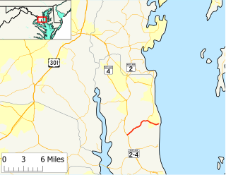
Maryland Route 261 is a state highway in the U.S. state of Maryland. The highway runs 12.86 miles (20.70 km) from MD 263 near Parran north to MD 778 at Friendship. MD 261 connects Prince Frederick with and serves as the main street through the Chesapeake Bay beach communities of Chesapeake Beach and North Beach in northeastern Calvert County and Rose Haven in southeastern Anne Arundel County. The highway was constructed from north of its present terminus through Chesapeake Beach in the early 1930s. The road was built as MD 613 east from Friendship in the mid-1930s and extended east to Rose Haven in the late 1940s. MD 261 was extended south to its present terminus near Parran and north through North Beach to Rose Haven in the mid-1950s. MD 261 took over MD 613 west to Friendship in the early 1960s.
Maryland Route 263 is a state highway in the U.S. state of Maryland. Known as Plum Point Road, the state highway runs 6.17 miles (9.93 km) from MD 2/MD 4 near Huntingtown east to a dead end at Plum Point. MD 263 also connects Prince Frederick with the northeastern Calvert County towns of Chesapeake Beach and North Beach; access to the towns is provided through a connection with MD 261 at Parran. The state highway was constructed in the late 1920s.
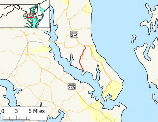
Maryland Route 264 is a state highway in the U.S. state of Maryland. Known as Broomes Island Road, the route runs 6.66 miles (10.72 km) from Oyster House Road at Broomes Island north to MD 2/MD 4 in Port Republic. MD 264 connects the central Calvert County communities of Broomes Island, Island Creek, and Mutual with the county's main highway at Port Republic. The state highway was constructed in the early 1920s.

Maryland Route 265 is a state highway in the U.S. state of Maryland. Known as Mackall Road, the state highway runs 1.75 miles (2.82 km) from the beginning of state maintenance near Mutual north to MD 264 at Mutual. MD 265 was constructed in the late 1920s and early 1930s. The state highway originally extended south through Wallville to St. Leonard Creek. MD 265's southern terminus was moved north four times between 1962 and 1995.

Maryland Route 402 is a state highway in the U.S. state of Maryland. Known for most of its length as Dares Beach Road, the state highway runs 4.33 miles (6.97 km) from MD 2 and MD 4 in Prince Frederick east to Chesapeake Avenue in Dares Beach. MD 402 was mostly constructed in 1932. Both termini have changed multiple times; the state highway settled into its present routing in the late 1950s.

Maryland Route 509 is a state highway in the U.S. state of Maryland. Known for most of its length as Governor Run Road, the state highway runs 1.14 miles (1.83 km) from MD 2 and MD 4 east to a dead end at the Chesapeake Bay within Port Republic. MD 509 was constructed east from what is now MD 765 in the early 1930s. The highway was extended west to MD 2 and MD 4 in the early 1980s.

Maryland Route 521 is a state highway in the U.S. state of Maryland. Known as Hunting Creek Road, the state highway runs 4.43 miles (7.13 km) from Lowery Road near Huntingtown north to MD 524 in Huntingtown. MD 521 was constructed in the early 1930s.
Cresswell Road is a designated state route in the Northern Territory of Australia. Forming part of State Route 16, it connects Calvert Road near Elliott with the Tablelands Highway and the Barkly Stock Route.