Camphora | |
---|---|
Unincorporated community | |
Coordinates: 36°27′11″N121°22′16″W / 36.45306°N 121.37111°W Coordinates: 36°27′11″N121°22′16″W / 36.45306°N 121.37111°W | |
Country | United States |
State | California |
County | Monterey County |
Elevation [1] | 171 ft (52 m) |
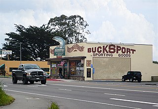
Camphora (formerly, Camp Four) is an unincorporated community in Monterey County, California. [1] It is located on U.S. Route 101 and the Southern Pacific Railroad line, 3 miles (4.8 km) northwest of Soledad, [2] at an elevation of 171 feet (52 m). [1]
In law, an unincorporated area is a region of land that is not governed by a local municipal corporation; similarly an unincorporated community is a settlement that is not governed by its own local municipal corporation, but rather is administered as part of larger administrative divisions, such as a township, parish, borough, county, city, canton, state, province or country. Occasionally, municipalities dissolve or disincorporate, which may happen if they become fiscally insolvent, and services become the responsibility of a higher administration. Widespread unincorporated communities and areas are a distinguishing feature of the United States and Canada. In most other countries of the world, there are either no unincorporated areas at all, or these are very rare; typically remote, outlying, sparsely populated or uninhabited areas.
Monterey County, officially the County of Monterey, is a county located on the Pacific coast of the U.S. state of California. As of the 2010 census, the population was 415,057. The county seat and largest city is Salinas.
California is a state in the Pacific Region of the United States. With 39.6 million residents, California is the most populous U.S. state and the third-largest by area. The state capital is Sacramento. The Greater Los Angeles Area and the San Francisco Bay Area are the nation's second and fifth most populous urban regions, with 18.7 million and 8.8 million residents respectively. Los Angeles is California's most populous city, and the country's second most populous, after New York City. California also has the nation's most populous county, Los Angeles County, and its largest county by area, San Bernardino County. The City and County of San Francisco is both the country's second-most densely populated major city after New York City and the fifth-most densely populated county, behind only four of the five New York City boroughs.
Camphora began in 1873 as a railroad construction camp called Camp Four. [2] Mexican workers pronounced the place as "camphora" and the railroad used this as the official name of the town. [2]
Camp Four, Camp 4, or Camp IV may refer to:
Caliente is an unincorporated community in Kern County, California. It is located 22 miles (35 km) east-southeast of Bakersfield, at an elevation of 1,312 feet (400 m).
Manzanar was a town in Inyo County, California found by Canadian-American water engineer George Chaffey.
Pinedale is a previously unincorporated community in Fresno County, California. It lies at an elevation of 348 feet. It was once a rural community located on the Southern Pacific Railroad 3.5 miles (5.6 km) north-northwest of Clovis but has since become surrounded and annexed by the city of Fresno. Millerton Lake State Recreational Area is to its NE. The ZIP Code is 93650, and the community is inside area code 559.
Pulga is an unincorporated community in Butte County, California. It is located along the west slope of the Feather River canyon, at an elevation of 1398 feet. A variant name for the community is Big Bar. Other nearby communities include Mayaro, Poe and Parkhill. The town hosts a Caltrans highway maintenance station along State Route 70 (SR70). The place is at the mouth of the Flea Valley Creek, which gives rise to the toponym.
Arboga is an unincorporated community in Yuba County, California. It is located 3 miles (4.8 km), south of Olivehurst on the Sacramento Northern Railroad, at an elevation of 56 feet. It was named in 1911 by the pastor of the Mission Covenant Church of Sweden for his hometown of Arboga, Sweden.
Fort Camp is a former settlement in Fresno County, California. It was located on the Atchison, Topeka and Santa Fe Railroad and the Fresno Interurban Railroad 4.25 miles (6.8 km) south-southeast of Clovis, at an elevation of 341 feet. It still appeared on maps as of 1923.
Bucksport was a town in Humboldt County, California. The original location was 2.5 miles (4 km) southwest of downtown Eureka, on Humboldt Bay about 5 miles (8 km) northeast of entrance. at an elevation of 16 feet (4.9 m). Prior to American settlement a Wiyot village named Kucuwalik stood here.
Crannell is a former settlement in Humboldt County, California. It is located 4.5 miles (7.2 km) southeast of Trinidad, at an elevation of 203 feet (62 m).
Fort Seward is an unincorporated community in Humboldt County, California. It is located on the Eel River 3.5 miles (5.6 km) north-northwest of Alderpoint, at an elevation of 328 feet.
Cactus is an unincorporated community in Imperial County, California. It is located on the Southern Pacific Railroad 4.5 miles (7.2 km) northwest of Ogilby, at an elevation of 394 feet.
Cawelo is an unincorporated community in Kern County, California. It is located on the Southern Pacific Railroad at an elevation of 427 feet (130 m). Cawelo is approximately 2 miles (3 km) east of Shafter-Minter Field, 6.5 miles (10 km) east of central Shafter, and 13 miles (21 km) northwest of Bakersfield. Its ZIP Code is 93263.
Hazelton is an unincorporated community in Kern County, California. It is located on the Sunset Railroad 1.5 miles (2.4 km) southeast of Maricopa, at an elevation of 771 feet (235 m).
Bothin is a former settlement in Marin County, California. It was located on the Northwestern Pacific Railroad 8 miles (13 km) south-southwest of downtown Novato, at an elevation of 292 feet. Bothin still appeared on maps as of 1914.
Andersonia is an unincorporated community in Mendocino County, California. It is located near U.S. Route 101 on the South Fork of the Eel River 1 mile (1.6 km) north-northwest of Piercy, at an elevation of 541 feet.
DeCamp is an unincorporated community in Mendocino County, California. It is located on the Northwestern Pacific Railroad 2 miles (3.2 km) north of Willits, at an elevation of 1342 feet.
Mono Mills is a ghost town in Mono County, California. It is located 9.5 miles (15 km) east-southeast of Lee Vining, at an elevation of 7356 feet. Mono Mills has nearly vanished. Its site is along California State Route 120, 9.1 miles (15 km) east from the junction with U.S. Route 395.
Metz is an unincorporated community in the Salinas Valley, in Monterey County, California. It is located on the Southern Pacific Railroad and County Route G15, 3 miles (4.8 km) northeast of Greenfield, at an elevation of 236 feet.
Rodgers Flat is an unincorporated community in Plumas County, California. It lies at an elevation of 2096 feet. Rodgers Flat is located on the Western Pacific Railroad, 3.5 miles (5.6 km) northeast of Storrie.
Camp Noyo is an unincorporated community in Mendocino County, California, United States. There is a camp named after the unincorporated community making it what is the name of the community today Camp Noyo. The settlement was originally a logging camp, and a stop along the California Western Railroad.
![]() | This Monterey County, California-related article is a stub. You can help Wikipedia by expanding it. |