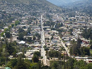
Canela, Chile

Last updated
Canela
Canela baja.jpg
Canela Baja
Logo canelas.jpg
Coat of Arms of Canela.svg
Comuna de Canela.svg
Chile location map.svg
Red pog.svg
Canela
Location in Chile
Coordinates(city): 31°23′56″S71°27′22″W / 31.39889°S 71.45611°W / -31.39889; -71.45611 Coordinates: 31°23′56″S71°27′22″W / 31.39889°S 71.45611°W / -31.39889; -71.45611
Country Flag of Chile.svg  Chile
Region Flag of Coquimbo Region, Chile.svg  Coquimbo
Province Choapa
Named for Quechua: sun sparkling
Capital Canela Baja
Government
  Type Municipality
   Alcalde Juan Bernardo Leyton Lemus
Area
[3]
  Total2,196.6 km2 (848.1 sq mi)
Elevation
295 m (968 ft)
Population
 (2012 Census) [3]
  Total9,182
  Density4.2/km2 (11/sq mi)
   Urban
1,744
   Rural
7,635
Demonym(s) Canelino/a
Sex
[3]
  Men4,737
  Women4,642
Time zone UTC-4 (CLT [4] )
  Summer (DST) UTC-3 (CLST [5] )
Area code(s) 56 + 53
Website www.canela.cl

Canela is one of four communes in the Choapa Province of Chile's north-central IV Coquimbo Region. The capital is the town of Canela Baja.

Contents

Administration

Municipal building at Luis Infante No 520 in Canela Baja. Municipalidad canela.jpg
Municipal building at Luis Infante Nº 520 in Canela Baja.

As a commune, Canela is administered by a municipal council, headed by a directly elected alcalde. The municipal building (alcaldía) is located at Luis Infante Nº 520 in Canela Baja. [2] The commune is administered by alcalde Juan Bernardo Leyton Lemus (Independent-PC) from 2012 to 2016, who won the election with 50,21% of the vote against 41,15% of his nearest rival, former mayor Norman Araya Araya (Independent). The commune has a total of six councilors: [1]

  1. Manuel Ángel Navarro Vega (PC)
  2. Ana Margarita Vega Flores (PPD)
  3. Miguel Pereira Bugueño (RN)
  4. Darwin Cortés Palma (UDI)
  5. Néstor Valle Tapia (PC-Ind.)
  6. Gustavo Gallardo Trigo (PDC)

Canela belongs to the 9th electoral district and the 4th Senate District (for that of the Coquimbo Region). It is represented in the Chamber of Deputies of the National Congress by the Members Jorge Insunza Gregorio de las Heras (PPD) and Luis Lemus (PS). Currently, Coquimbo is represented in the Senate by Jorge Pizarro (PDC) and Adriana Muñoz (PPD).

Geography

Canela spans an area of 2,196.6 km (1,365 mi). [3] The commune is bordered to the west by the Pacific Ocean and to the north by three communes of the Limarí Province: Ovalle, Punitaqui, and Combarbalá to the north and east. To the southeast lies the commune of Illapel, and Los Vilos borders on the south. Canela Baja is located approximately 12 km (7 mi) east of the Panamerican Highway, Route 5, at kilometer 299.

Climate

The waters of the Canela stream flow into the Choapa River, which drains into the Pacific Ocean. The area's climate is steppe or semiarid. The average annual precipitation is about 169.51 mm (7 in).

Demographics

According to data from the 2002 Census of Population and Housing, the Canela commune had 9,379 inhabitants; of these, 1,744 (18.9%) lived in urban areas and 7,635 (81.4%) in rural areas. Thus, the Canela population represents 1.5% of regional population and 11.4% of the provincial population.

Related Research Articles

Illapel City and Commune in Coquimbo, Chile

Illapel is a Chilean city, which is the capital of the Choapa Province, Coquimbo Region. It lies along the Illapel River and marks the country's narrowest point along a parallel (94 km). It is located to the east of Los Vilos.

El Bosque is a commune of Chile located in Santiago Province, Santiago Metropolitan Region. The commune spans an area of 14.1 km2 (5 sq mi).

La Pintana City and Commune in Chile

La Pintana is a commune of Chile located in Santiago Province, Santiago Metropolitan Region. La Pintana is home to Antumapu, the agricultural and veterinary sciences campus of University of Chile, Chile's oldest university.

Quinta Normal is a commune of Chile located in Santiago Province, Santiago Metropolitan Region. It is named after a large park in the area.
Recoleta, Chile City and Commune in Santiago Metro., Chile

Recoleta is a commune of Chile located in the north of Santiago Province. It belongs to the Santiago Metropolitan Region which is the capital and seat of the executive branch. It is south of Huechuraba, east of Independencia and Conchalí, west of Providencia and Vitacura, and north of Santiago. The Mapocho River and the San Cristóbal Hill form the natural boundary on the south and east sides, respectively, of Recoleta.

Coquimbo City and Commune in Chile

Coquimbo is a port city, commune and capital of the Elqui Province, located on the Pan-American Highway, in the Coquimbo Region of Chile. Coquimbo is situated in a valley 10 km (6 mi) south of La Serena, with which it forms Greater La Serena with more than 400,000 inhabitants. The commune spans an area around the harbor of 1,429.3 km2 (552 sq mi). The average temperature in the city lies around 14 °C (57 °F), and precipitation is low.

Cauquenes City and Commune in Maule, Chile

Cauquenes, a city and commune in Chile, is the capital of the Cauquenes Province and is located in the Maule Region.

Villa Alegre, Chile City and Commune in Maule, Chile

Villa Alegre a commune and city located in Linares Province, Maule Region of Chile. With 189.8 km2 (73 sq mi), Villa Alegre is the smallest commune by area in the Maule Region. It sits 92 m (302 ft) above sea level.
Los Vilos City and Commune in Coquimbo, Chile

Los Vilos? is both a Chilean coastal commune and a coastal city with over 9,000 inhabitants, located in the Province of Choapa, part of the IV Region of Coquimbo. The city has a harbour called Puerto Punta Chungo, that ships the material of Los Pelambres mine. Fishing is one of its main activities. The city also has a significant amount of tourism, mainly due to its two beaches: La Principal and Las Conchas. It is located at 246 kilometres (153 mi) from La Serena and 246 kilometres (153 mi) from Santiago.

Melipilla is a Chilean commune and capital city of the province of the same name, located in the Santiago Metropolitan Region southwest of the nation's capital. The commune spans an area of 1,344.8 km2 (519 sq mi).

Buin, Chile City and Commune in Santiago, Chile

Buin is a city and commune of Chile, in the Maipo Province, Metropolitan Region of Santiago, which forms part of Greater Santiago. It is a city composed of the towns of Maipo, Viluco, Linderos, Valdivia de Paine, Alto Jahuel, Los Guindos and El Recurso. Buin is located about 35 km (22 mi) south of Santiago in the Maipo Valley wine region.

Salamanca, Chile City and Commune in Coquimbo, Chile

Salamanca is a Chilean city and commune in Choapa Province, Coquimbo Region. It is located 30 km (19 mi) east of Illapel, the province's administrative center, and 316 km (196 mi) north of Santiago, Chile. It is normally accessed from Los Vilos, which lies next to the Panamerican Highway, and connects the city to the rest of the country.

Algarrobo, Chile Commune in Valparaíso, Chile

Algarrobo is a Chilean city and commune in San Antonio Province, Valparaíso Region. Located on the country's central coast, it is a popular summer resort for the population of Santiago. It is an upscale community near El Quisco and Valparaíso. The San Alfonso del Mar resort, located north of the city, is home to the world's largest outdoor pool.

San Nicolás, Chile Town and Commune in Ñuble, Chile

San Nicolás is a Chilean town and commune in Punilla Province, Ñuble Region.

Punitaqui Town and Commune in Coquimbo, Chile

Punitaqui is a town and commune of Chile in the Limarí Province.

Monte Patria City and Commune in Coquimbo, Chile

Monte Patria is a city and one of four communes in the Limarí Province of Chile's north-central IV Coquimbo Region.

Río Hurtado Commune in Coquimbo, Chile

Río Hurtado is one of five communes in the Limarí Province of Chile's north-central IV Coquimbo Region.

Alhué is a Chilean town and commune located in Melipilla Province, Santiago Metropolitan Region.

Santa María is a city and commune in the San Felipe de Aconcagua Province of central Chile's Valparaíso Region.

Nogales is a city and commune in the Quillota Province of central Chile's fifth region of Valparaíso.

References

  1. 1 2 "Municipality of Canela" (in Spanish). Retrieved 7 September 2010.
  2. 1 2 "Government of Chile: SUBDERE - Alcaldes and Councilors" (in Spanish). Archived from the original on June 6, 2007. Retrieved 1 September 2010.
  3. 1 2 3 4 "National Statistics Institute" (in Spanish). Retrieved 1 May 2010.
  4. "Chile Time". WorldTimeZones.org. Archived from the original on 2007-09-11. Retrieved 2010-07-29.
  5. "Chile Summer Time". WorldTimeZones.org. Archived from the original on 2007-09-11. Retrieved 2010-07-29.