
Great Bookham is a village in Surrey, England, one of six semi-urban spring line settlements between the towns of Leatherhead and Guildford. With the narrow strip parish of Little Bookham, it forms part of the Saxon settlement of Bocham. The Bookhams are surrounded by common land, and Bookham railway station in Church Road, Great Bookham, serves both settlements.
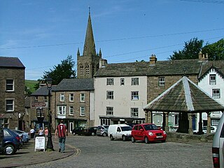
Alston is a town in Cumbria, England, within the civil parish of Alston Moor on the River South Tyne. It shares the title of the 'highest market town in England', at about 1,000 feet (300 m) above sea level, with Buxton, Derbyshire. Despite its altitude, the town is easily accessible via the many roads which link the town to Weardale, Teesdale, and towns in Cumbria such as Penrith via Hartside Pass, as well as Tynedale. Historically part of Cumberland, Alston lies within the North Pennines, a designated Area of Outstanding Natural Beauty. Much of the town centre is a designated Conservation Area which includes several listed buildings.
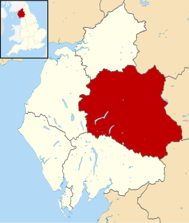
Eden is a local government district in Cumbria, England, based at Penrith Town Hall in Penrith. It is named after the River Eden, which flows north through the district toward Carlisle. Its population of 49,777 at the 2001 census, increased to 52,564 at the 2011 Census. A 2019 estimate was 53,253. In July 2021 it was announced that in April 2023, Cumbria will divide into two unitary authorities. Eden District Council will cease and its functions pass to a new authority, Westmorland and Furness Council, covering the current districts of Barrow-in-Furness, Eden and South Lakeland.

Penrith is a market town and civil parish in the county of Cumbria, England, less than 3 miles (5 km) outside the Lake District National Park. It had a population of 15,181 at the 2011 Census. Historically in Cumberland, Penrith's local authority is currently Eden District Council, which is based in the town, as were the defunct Penrith Urban and Rural District councils. From 1974 to 2015, it was an unparished area with no local council, but a civil parish was reintroduced as Penrith Town Council and first elected on 7 May 2015.

Erdington is a suburb and ward of Birmingham that is historically part of Warwickshire. It is 5 miles (8 km) northeast of central Birmingham, England and borders Sutton Coldfield. It was also a council constituency, managed by its own district committee. The former council district consisted of the ward of Erdington, and Tyburn,, Stockland Green and Kingstanding, although all of Kingstanding and most of both Tyburn and Stockland Green wards lie outside the historical boundaries of Erdington. Stockland Green was formerly part of Aston, Kingstanding part of Perry Barr and Tyburn partially split between Aston and Hodge Hill. Erdington (ward) was part of the Sutton Coldfield constituency before 1974.

Aylestone is a suburb of Leicester, England, southwest of the city centre and to the east of the River Soar. It was formerly a separate village, but the growth of the city since the Leicester Extension Act of 1891 incorporated Aylestone into the Borough of Leicester and it is now part of the suburban area.

Seacroft is an outer-city suburb/township consisting mainly of council estate housing covering an extensive area of east Leeds, West Yorkshire, England. It lies in the LS14 Leeds postcode area, around 4 miles (6.4 km) east of Leeds city centre.

Kingsthorpe is a suburb and civil parish of Northampton, England. It is situated to the north of Northampton town centre and is served by the A508 and A5199 roads which join at Kingsthorpe's centre. The 2011 Census recorded the population of the district council ward as 4,477.

Walmley is a village in Sutton Coldfield, Birmingham, England. It is in south Sutton Coldfield, near to Erdington, Minworth, Wylde Green, Pype Hayes and south of Thimble End. It is approximately 6 miles (9.7 km) northeast of Birmingham City Centre. It is the main focus of the Sutton New Hall Birmingham City Council ward.

Manor House, also known as Woodberry Down, is an area of North London in the northwest corner of the London Borough of Hackney. It lies immediately east of Finsbury Park, north of Stoke Newington, west of Stamford Hill and Seven Sisters, and south of Harringay. The area was originally known as Woodberry Down. However, the construction of the Seven Sisters Road and the consequent establishment of the Manor House Tavern gave rise to the alternative name Manor House Crossroads and with the arrival of the tube station in 1932, the area immediately around the tube station began to be known as Manor House. The demolition of the once very fashionable area of Woodberry Down and its replacement with one of London's biggest public housing estates resulted in 'Woodberry Down Estate' being used to refer to the public housing area and 'Manor House' for the area beyond. With the regeneration of the area during the early part of the 21st Century, the area is now being referred to once again by its nineteenth-century name of 'Woodberry Down'.
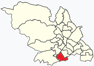
Beauchief and Greenhill ward—which includes the districts of Batemoor, Beauchief, Chancet Wood, Greenhill, Jordanthorpe, and Lowedges—is one of the 28 electoral wards in City of Sheffield, England. It is located in the southern part of the city and covers an area of 2.4 square miles (6.2 km2). The population of this ward in 2016 was estimated to be 19,669 people in 9,209 houses.

Mosborough is an electoral ward of the City of Sheffield, England, in the eastern part of the city, on the border with Rotherham. The population in 2011 was 17,097. It is one of the wards that make up the Sheffield South East constituency.

Walderslade is a large suburb in Kent to the south of Chatham split between the unitary authority of Medway and the boroughs of Maidstone and Tonbridge & Malling in South East England. It was, until 1998, fully part of Kent and is still ceremonially associated via the Lieutenancies Act. It encompasses almost all the ME5 postcode district.

Frampton Cotterell is a village and parish, in South Gloucestershire, South West England, on the River Frome. The village is contiguous with Winterbourne to the south-west and Coalpit Heath to the east. The parish borders Iron Acton to the north and Westerleigh to the south-east, the large town of Yate is 2.1 miles (3.4 km) away. The village is 7.5 miles (12 km) north-east of the city of Bristol.

Acton is a community in Wrexham County Borough, Wales. It lies in the north-eastern part of the market town of Wrexham. The area is largely residential and at its centre, lies Acton Park, the location of the former Acton Hall.

Bitterne is an eastern suburb and ward of Southampton, England.

Heathfield and Waldron is a civil parish within the Wealden District of East Sussex, England. Heathfield is surrounded by the High Weald Area of Outstanding Natural Beauty.

The A686 is a road in Northern England. It runs from Penrith in Cumbria to Haydon Bridge in Northumberland. AA Magazine named the A686 as one of their "Ten Great Drives" owing to the dramatic scenery of the North Pennines hills encountered along its route. Travel journalist Phil Llewellin said:
England’s great wilderness sprawls across the northern Pennines, where the mountains have fascinating names such as Fiend’s Fell and Wildboar Fell. Penrith merits a visit after leaving the M6, and memories of the motorway fade as the A686 crosses the River Eden valley. The mood changes dramatically in Melmerby, where the road starts its long climb to the cafe at Hartside, 1,900 feet (580 m) above sea level, with stunning views across the Solway Firth and Scotland. The road leads to Alston, which claims to be England’s highest market town, a charming little place with cobbled streets and quaint buildings. The A686 beyond Alston crosses another breathtaking expanse of windswept upland before running down to the River Allen’s beautiful wooded gorge.


