Carpenter's Road Lock

Last updated

Carpenter's Road Lock
Carpenters Lock from Marshgate Lane 1.jpg
Carpenter's Road Lock, seen from Marshgate Lane, before the construction of the Olympic Park
Carpenter's Road Lock
51°32′30″N0°00′59″W / 51.541774°N 0.016437°W / 51.541774; -0.016437
Waterway Bow Back Rivers
County Newham
Greater London
Maintained by Canal and River Trust
Operationautomatic (original)
First built1934
Length92 feet (28 m)
Width20 feet (6.1 m)
Fallwas tidal

Carpenter's Road Lock is a rising radial lock in the London Borough of Newham, near Marshgate Lane in Stratford, England. It is located on the Bow Back Rivers and was constructed in 1933/34. It is the only lock in Britain with rising radial gates at both ends. British Waterways were hoping to restore it as part of the upgrade to Bow Back Rivers which took place for the 2012 Summer Olympics, but the gantries which enabled the gates to be raised were demolished to accommodate a wide bridge giving access to the main stadium. After the Games, most of the overbridge was removed. Funding for the restoration of the lock was in place by early 2016, and it is expected to be brought back into use in 2017.

Contents

History

The Bow Back Rivers are a network of channels, which although they form a link between the River Lea and the River Thames, were never officially a part of the Lee Navigation. They were used commercially for navigation, but no tolls could be collected and there was no incentive to the trustees or conservators of the Lea to spend any money on their maintenance. [1] Most of the channels had at various times been associated with water mills, [2] and also formed an essential part of the flood relief system of the River Lea, but by the 1920s, they posed a flood risk to the surrounding area as they became choked. At the time, there were high rates of unemployment in the West Ham area, and the government had recently introduced an unemployment relief scheme. West Ham Corporation, working with the Lee Conservancy Board, applied for and received grants to enable major improvements to be carried out to the Bow Back Rivers. [1] The work was authorised by the granting of an Act of Parliament, the River Lee (Flood Relief) Act 1930. [3]

The work included dredging and reconfiguration of most of the channels, a new lock at Bow, rebuilding of Marshgate Lock on a new site further to the east, and the construction of a new lock at Carpenter's Road, at the northern end of the City Mills River. The whole project took around four years to complete, with work starting in 1931. [1] Work on the lock itself, which was 92 feet (28 m) long and 20 feet (6.1 m) wide, began in 1933, and it was completed in 1934. It was built with rising radial gates at both ends. The use of rising radial gates was fairly common in continental Europe, but Carpenter's Road was the first use of them in Britain. The choice was dictated by the fact that the structure had to act both as a navigation lock and as a means of discharging flood water. It also had to be able to cope with variable water levels in both the City Mills River to the south, and the tidal Waterworks River to the north, where either one could be higher than the other. It was therefore built with two rising radial gates, one at each end. [4]

The lock was built with a gantry over each of the gates, which housed the counterbalance weights and the operating mechanism. There were also steps up to the gantry, so that it provided a footbridge from one side of the lock to the other. Each gate, which formed an arc, could be raised out of the water in order to allow a boat to pass underneath it. A house for the lock keeper was completed by February 1935, and the lock was officially named Ward's Lock, after a local councillor, but soon became Carpenter's Road Lock. The lock house was demolished in 1967. Three other locks were built on the British canal system with rising radial gates, but this was the only one with such gates at both ends. [4] Use of the Bow Back Rivers declined, and the last use of the lock by commercial traffic was in the 1960s. [5] By the mid 1970s, both Carpenter's Road Lock and the new Marshgate Lock, by then known as City Mills Lock, were impassible and virtually derelict. [1]

The lock controlled access to the northern section of the City Mill River, the southern approach being controlled by City Mills Lock. Two locks were needed as, when tidally controlled, there was insufficient headroom for barges passing beneath the Northern Outfall Sewer, which passes over the City Mill River.

Restoration

The gantries were demolished and the lock was blocked off with stop planks during the Olympic event Carpenters Road Lock geograph-4553500.jpg
The gantries were demolished and the lock was blocked off with stop planks during the Olympic event

As a result of the passing of the Transport Act 1968, Bow Back Rivers were classified as a remainder waterway, meaning that no investment was likely to be made in them. However, in 2002, British Waterways decided that full restoration of the channels should be a national priority, and the Mayor of London ensured that this was included in the London Plan. [6] By 2006, the International Olympic Committee had awarded the 2012 Games to London, and the chosen site for the main venues included most of the Bow Back Rivers. Initial restoration of City Mills Lock was completed early that year, [7] In July 2006, the Olympic Development Authority sanctioned the building of a new lock on the Prescott Channel, which was subsequently named Three Mills Lock. Its purpose was to control water levels in the Waterworks River, maintaining them at a level where navigation was possible throughout the day. Previously, it had been a muddy creek at low tide, and at high tide, there was inadequate headroom to pass beneath the Northern Outfall Sewer, which crossed on a low bridge. [8] The lock and associated flood defence structure were completed in 2009. [6]

Once Three Mills Lock was operational, the Waterworks River was no longer tidal, and so water levels at Carpenter's Road Lock were more predictable. In 2010, British Waterways were hopeful that negotiations with High Speed 1 Ltd, who were operating the Channel Tunnel rail link, would result in £800,000 towards the cost of restoring Carpenter's Road Lock. This was part of a larger programme to ensure that the Stratford and Olympic areas were adequately drained. [9] Little progress was made, and with the 2012 Olympic stadium sited about 100 metres (109 yd) south of the lock, on an island site between the Old River Lea and the City Mill River which branches just to the south of the lock, it was cosmetically restored and a wide bridge was constructed above the lock from Stratford City to the stadium. In order to accommodate the bridge, the gantries and ramps were demolished. [4]

By early 2016, the wide bridge over the lock had been demolished, and replaced by much narrower structures, to allow the lock to be rebuilt. The Canal & River Trust, successors to British Waterways, approved a £1.75 million project to restore the lock in February 2016. Grants of £680,000 were received from the Heritage Lottery Fund, £100,000 from the London Legacy Development Corporation and £4,500 from the Inland Waterways Association. Restoration saw the gantries replaced, to accommodate the counterbalance weights, and two new radial rising gates installed. These enable the new structure to operate as a lock, and also to distribute flood water to the various channels in the Bow Back Rivers when the need arises. Operation of the gates to achieve this is automatic. [10] [11] Hyder Consulting managed the project, with Kier Construction carrying out the construction work. The new radial gates and control gear were designed by Kgal, and because there is limited headroom, they were built as a series of modules, each weighing less than 0.5 tonnes, which were assembled on site. During the Olympics, the underside of the bridge over the lock was covered in mirrors, and this feature has been retained on the new narrower structure. [12] The job of manufacturing the gates, the new gantries and the controls was awarded to Mayflower Engineering of Sheffield. The gantries were clad in weathering steel, which forms a rust-coloured protective layer over time, and this is designed to contrast with the bridge over the lock, which is clad in stainless steel. [13]

The gates were installed at the lock in mid-May, 2017. [14] The reconstructed lock was formally opened as part of the first East London Waterways Festival, held over the August bank holiday. The event was attended by over 50 narrow boats and around 700 boaters, many using paddles or pedal-powered craft. All of the powered boats made a passage through the lock. One anomaly is that the 0.5-mile (0.8 km) stretch of the navigable River Lea to the north of Carpenter's Road lock is managed by Lea Valley Regional Park Authority, and they do not allow powered boats to use it. [15]

Related Research Articles

<span class="mw-page-title-main">North Walsham & Dilham Canal</span> Waterway in the English county of Norfolk

The North Walsham and Dilham Canal is a waterway in the English county of Norfolk. It was authorised by Parliament in 1812, but work on the construction of a canal which ran parallel to a branch of the River Ant did not start until 1825. It included six locks, which were sized to accommodate wherries, and was officially opened in August 1826. It was 8.7 miles (14.0 km) long and ran from two bone mills at Antingham to a junction with the River Ant at Smallburgh. It carried offal for the bone mills and agricultural products, as it proved cheaper to land coal on the beach at Mundesley and cart it overland than to use the canal.

<span class="mw-page-title-main">Chelmer and Blackwater Navigation</span> United Kingdom legislation

The Chelmer and Blackwater Navigation is the canalisation of the Rivers Chelmer and Blackwater in Essex, in the east of England. The navigation runs for 13.75 miles (22.13 km) from Springfield Basin in Chelmsford to the sea lock at Heybridge Basin near Maldon. Initial plans faced spirited opposition from Maldon, which were overcome by avoiding the town and terminating at Heybridge, and the navigation opened in 1797. There were some teething problems, and the engineer John Rennie was called back on two occasions to recommend improvements. The impact of the railways was less severe than on many canals, as there was never a direct line between Chelmsford and Maldon. The sea lock at Heybridge was enlarged after the Second World War, but trade gradually declined and ceased in 1972.

<span class="mw-page-title-main">River Lea</span> River in the south east of England

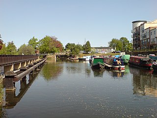
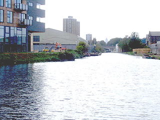
The River Lea is in the East of England and Greater London. It originates in Bedfordshire, in the Chiltern Hills, and flows southeast through Hertfordshire, along the Essex border and into Greater London, to meet the River Thames at Bow Creek. It is one of the largest rivers in London and the easternmost major tributary of the Thames.

<span class="mw-page-title-main">Hertford Union Canal</span> Canal in the London Borough of Tower Hamlets

The Hertford Union Canal or Duckett's Cut, just over 1 mile (1.6 km) long, connects the Regent's Canal to the Lee Navigation in the London Borough of Tower Hamlets in East London. It was opened in 1830 but quickly proved to be a commercial failure. It was acquired by the Regents Canal Company in 1857, and became part of the Grand Union Canal in 1927.

<span class="mw-page-title-main">Bow Creek (London)</span> River in England

Bow Creek is a 2.25-mile (3.6 km) long tidal estuary of the English River Lea and is part of the Bow Back Rivers. Below Bow Locks the creek forms the boundary between the London Boroughs of Newham and Tower Hamlets, in East London.

<span class="mw-page-title-main">Bow Back Rivers</span> Waterways in east London

Bow Back Rivers or Stratford Back Rivers is a complex of waterways between Bow and Stratford in east London, England, which connect the River Lea to the River Thames. Starting in the twelfth century, works were carried out to drain Stratford Marshes and several of the waterways were constructed to power watermills. Bow Creek provided the final outfall to the Thames, and the other channels were called Abbey Creek, Channelsea River, City Mill River, Prescott Channel, Pudding Mill River, Saint Thomas Creek, Three Mills Back River, Three Mills Wall River and Waterworks River.

<span class="mw-page-title-main">Montgomery Canal</span> Canal in Shropshire, England, and Powys, Wales

The Montgomery Canal, known colloquially as "The Monty", is a partially restored canal in eastern Powys and northwest Shropshire. The canal runs 33 miles (53 km) from the Llangollen Canal at Frankton Junction to Newtown via Llanymynech and Welshpool and crosses the England–Wales border.

<span class="mw-page-title-main">City Mill River</span> Canal in east London, England

City Mill River is part of the Bow Back Rivers in London, England. It formerly fed City Mill, used for the production of chemicals in the late nineteenth and early twentieth centuries. In the 1930s, the mill was removed and the river was isolated from the tides by the construction of locks at both ends. City Mill Lock, at the southern end, has been refurbished and reopened in 2010.

<span class="mw-page-title-main">Lower Lea Valley</span> Southern end of the Lea Valley in Greater London

The Lower Lea Valley is the southern end of the Lea Valley which surrounds the River Lea in eastern Greater London. It is part of the Thames Gateway redevelopment area and was the location of the 2012 Summer Olympics.

<span class="mw-page-title-main">Ribble Link</span> Canal in Lancashire

The Millennium Ribble Link is a linear water park and new navigation which links the once-isolated Lancaster Canal in Lancashire, England to the River Ribble. The Lancaster Canal was never connected to the rest of the English waterways network, because the planned aqueduct over the River Ribble was never built. Instead, a tramway connected the southern and northern parts of the canal. An idea for a connecting link following the course of the Savick Brook was proposed in 1979, and the Ribble Link Trust campaigned for twenty years to see it built. The turn of the Millennium, and the funds available from the Millennium Commission for projects to mark the event was the catalyst for the project to be implemented, and although completion was delayed, the navigation opened in July 2002.

<span class="mw-page-title-main">Buckingham Arm</span> English canal

The Buckingham Arm is an English canal that once ran from Cosgrove, Northamptonshire to Buckingham. It was built as an arm of the Grand Junction Canal in two separate phases, a broad canal to Old Stratford, which opened in 1800 and a narrow canal onwards to Buckingham, which opened in 1801. It was disused from 1932, and was dammed at the first bridge in 1944 to reduce leakage from the Grand Union Canal, as the Grand Junction had then become known, but was not finally abandoned until 1964. The remains were severed by the construction of new roads in the 1970s and again in the late 1980s. The section through Old Stratford and Deanshanger was sold off in the 1990s, and the route there has been lost to housing development. The Buckingham Canal Society was formed in 1992, and is actively pursuing a restoration programme. Some 440 yards (400 m) of the canal near Buckingham are now holding water, but the main focus in 2020 was at the Cosgrove end, where a restored channel would be accessible by boat from the Grand Union. Progress was made in September 2023, when 550 yards (500 m) of canal were reopened to navigation.

<span class="mw-page-title-main">Prescott Channel</span> Canal in East London, England

The Prescott Channel was built in 1930–35 as part of a flood relief scheme for the River Lee Navigation in the East End of London, England, and was named after Sir William Prescott, the then chairman of the Lee Conservancy Board. Rubble from the demolished Euston Arch was used in 1962 to improve the channel, which forms part of the Bow Back Rivers.

<span class="mw-page-title-main">Bow Locks</span> Canal lock in London

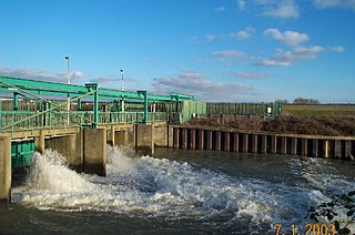
Bow Locks No. 20 is a set of bi-directional locks in Bromley-by-Bow in the London Borough of Tower Hamlets and Newham. The locks link the tidal Bow Creek to the River Lee Navigation, which is a canalised river. These locks were first built in 1850 and then rebuilt in 1930, at the same time as the Prescott Channel was cut nearby. At high tide, the tide from Bow Creek formerly flowed through Bow Locks, to raise the level of the canals, such as the Limehouse Cut. In 2000, these locks were modified to keep the tide out, to reduce silting in the canal system.

<span class="mw-page-title-main">Stroudwater Navigation</span> Canal in Gloucestershire, England

The Stroudwater Navigation is a canal in Gloucestershire, England which linked Stroud to the River Severn. It was authorised in 1776, although part had already been built, as the proprietors believed that an Act of Parliament obtained in 1730 gave them the necessary powers. Opened in 1779, it was a commercial success, its main cargo being coal. It was 8 miles (13 km) in length and had a rise of 102 ft 5 in (31.22 m) through 12 locks. Following the opening of the Thames and Severn Canal in 1789, it formed part of a through route from Bristol to London, although much of its trade vanished when the Kennet and Avon Canal provided a more direct route in 1810. Despite competition from the railways, the canal continued to pay dividends to shareholders until 1922, and was not finally abandoned until 1954.

<span class="mw-page-title-main">Lee Flood Relief Channel</span>

The Lee Flood Relief Channel (FRC) is located in the Lea Valley and flows between Ware, Hertfordshire, and Stratford, east London. Work started on the channel in 1947 following major flooding and it was fully operational by 1976. The channel incorporates existing watercourses, lakes, and new channels. Water from the channel feeds the Lee Valley Reservoir Chain.

<span class="mw-page-title-main">Old Ford Lock</span> Lock on the River Lee Navigation, London, England

Old Ford Lock is a paired lock and weir on the River Lee Navigation, in the London Borough of Tower Hamlets, England. It is at Fish Island in Old Ford and takes its name from the natural ford which used to cross the River Lea.

<span class="mw-page-title-main">Three Mills Lock</span> Lock on Prescott Channel

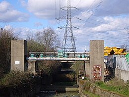
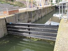
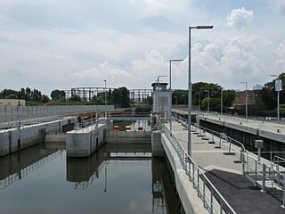
Three Mills Lock, also known as Prescott Lock, is a lock on the Prescott Channel on the River Lea in London. The current structure was constructed by British Waterways and officially opened on 5 June 2009.

<span class="mw-page-title-main">Three Mills Wall River Weir</span> Weir on the Bow Back Rivers in London, England

Three Mills Wall River Weir is a weir on the Bow Back Rivers, in Mill Meads in the London Borough of Newham, England, near to Three Mills. It was built in 2009, when the Bow Back Rivers were refurbished to make them a key feature of the Queen Elizabeth Olympic Park, and maintains water levels through much of the park in conjunction with the Three Mills Lock and sluice on the Prescott Channel.

<span class="mw-page-title-main">Hackney Cut</span> Canal in East London

The Hackney Cut is an artificial channel of the Lee Navigation built in England in 1769 by the River Lea Trustees to straighten and improve the Navigation. It begins at the Middlesex Filter Beds Weir, below Lea Bridge, and is situated in the (modern) London Borough of Hackney. When built it contained two pound locks and a half-lock, but was rebuilt to handle larger barges in the 1850s, and now only Old Ford Lock, which is actually a duplicated pair, remains.

<span class="mw-page-title-main">Waterworks River</span>

Waterworks River is a river, at one time a tidal river, in the London Borough of Newham, one of the Bow Back Rivers that flow into the Bow Creek part of the River Lea, which in turn flows into the River Thames.

References

  1. 1 2 3 4 Boyes & Russell 1977, p. 36.
  2. Boyes & Russell 1977, p. 35.
  3. Nicholson 2006, p. 104.
  4. 1 2 3 "Bow Back Rivers". Lee and Stort. Archived from the original on 22 May 2022.
  5. "IWA London Region contributes to Olympic Park Lock restoration". Towpath Talk. 20 May 2016. Archived from the original on 29 October 2016. Retrieved 28 October 2016.
  6. 1 2 "Bow Back Rivers – A potted history". British Waterways. Archived from the original on 7 February 2012.
  7. "First steps in Bow Back regeneration". Waterways World. Waterways World. February 2006. p. 42. ISSN   0309-1422.
  8. "Olympic Freight Hope". Waterways World. Waterways World. September 2006. p. 45. ISSN   0309-1422.
  9. "London lock to be restored". Waterways World. Waterways World. August 2010. p. 44. ISSN   0309-1422.
  10. Ranson, Jacob (24 February 2016). "Stratford lock given a £1.75 million boost". Newham Recorder. Archived from the original on 20 December 2016.
  11. "£1.75 million to restore historic lock at Olympic Park". canalrivertrust.org.uk. Canal & River Trust. Archived from the original on 8 May 2021. Retrieved 25 February 2016.
  12. "Radial lock gate design for London's hidden canal". Kgal Global. Archived from the original on 29 July 2021. Retrieved 29 October 2016.
  13. "Mayflower helps to restore historic lock". Mayflower Engineering. Archived from the original on 17 May 2019. Retrieved 31 October 2016.
  14. "London's new cruising ring" (PDF). Waterways World. July 2017. p. 43. ISSN   0309-1422. Archived (PDF) from the original on 8 January 2023.
  15. "East London Waterways Festival 'smashing' say boaters" (PDF). Waterways World. November 2017. p. 28. ISSN   0309-1422. Archived (PDF) from the original on 8 January 2023.

Bibliography