
The fourth Berkley–Dighton Bridge is a four-span concrete arch bridge with closed spandrel walls of cast-in-place concrete, using pile-supported abutments and piers. The bridge was made such that it appears to be constructed of stone masonry rather than concrete. The two end spans are 74 feet (23 m) and the two center spans are 92 feet (28 m) for a total bridge length of approximately 350 feet (110 m).

The Church Street Covered Bridge, also called the Village Covered Bridge, is a wooden covered bridge that crosses the North Branch of the Lamoille River in Waterville, Vermont off State Route 109. Built in the late 19th century, it is one of five covered bridges in a space of about five miles that cross the North Branch Lamoille. It was listed on the National Register of Historic Places in 1974.

The Ashuelot Covered Bridge is a historic wooden covered bridge over the Ashuelot River on Bolton Road, just south of its intersection with NH 119 in Ashuelot, an unincorporated village of Winchester, New Hampshire. Built in 1864-65, it is one of the state's few surviving 19th-century covered bridges. It was listed on the National Register of Historic Places in 1981.

Watson Settlement Bridge was a historic covered bridge in eastern Littleton, Maine, United States. Built in 1911, it was one of the youngest of Maine's few surviving covered bridges. It formerly carried Framingham Road over the Meduxnekeag River, but was closed to traffic, the road passing over a modern bridge to its south. It was listed on the National Register of Historic Places in 1970. It was destroyed by fire on July 19, 2021, and subsequently delisted from the National Register in 2023.

The West Dummerston Covered Bridge is a historic covered bridge spanning the West River in Dummerston, Vermont, between Vermont Route 30 and Camp Arden Road. Built in 1872, it is at 280 feet (85 m) the longest covered bridge entirely within the state of Vermont. It was listed on the National Register of Historic Places in 1973.

The Halpin Covered Bridge, also called the High Covered Bridge, is a wooden covered bridge carrying Halpin Bridge Road across the Muddy Branch of the New Haven River in Middlebury, Vermont. It was listed on the National Register of Historic Places in 1974.
The Northfield Falls Covered Bridge, also called the Station Covered Bridge, is a wooden covered bridge that carries Cox Brook Road across the Dog River in Northfield, Vermont. Built in 1872, this Town lattice truss bridge is one of five surviving covered bridges in the town, and one of two that are visible from each other. It was listed on the National Register of Historic Places in 1974.

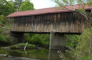
The Mill Covered Bridge is a wooden covered bridge that crosses the North Branch Lamoille River on Back Road in Belvidere, Vermont. Built about 1890, it is one of two surviving covered bridges in the rural community. It was listed on the National Register of Historic Places in 1974.

The Hammond Covered Bridge is a Town lattice covered bridge spanning Otter Creek in Pittsford, Vermont. The bridge was built in 1842 by Asa Norse, and originally carried Kendall Hill Road, which now passes just to its south. The bridge was added to the National Register of Historic Places on January 21, 1974.
The Eldean Covered Bridge is a historic covered bridge spanning the Great Miami River in Miami County, Ohio north of Troy. Built in 1860, it is one of the nation's finest surviving examples of a Long truss, patented in 1830 by engineer Stephen H. Long. At 224 feet (68 m) in length for its two spans, it is the longest surviving example of its type. It was listed on the National Register of Historic Places in 1975, and was designated a National Historic Landmark in 2016.

The Gilsum Stone Arch Bridge carries Surry Road over the Ashuelot River in Gilsum, New Hampshire. Built in 1862–63, it is one of the highest stone arch bridges in the state. It has a span of 47 feet 8 inches (14.53 m), and an average height over the river of 36 feet 6 inches (11.13 m). The roadway is 43 feet 6 inches (13.26 m) above the riverbed. It stands on the site of four previous bridges, where the river passes through a deep gorge. The previous bridge was also a stone arch bridge, which was built in 1860 and collapsed a few months later. It was designed by William Leonard Kingsbury, a local official; its builders are not known because the town's records were destroyed in a fire. The present bridge's vault is carefully constructed from dry-laid granite voussoirs that were shaped for a very precise fit, with larger stones at the lower ends of the arch, and a smaller ones at the crown. Some of the stones were left with rough surfaces, while others were hammered smooth.

The Hillsborough Railroad Bridge was a historic covered railroad bridge spanning the Contoocook River in Hillsborough, New Hampshire. Built in 1903 by the Boston and Maine Railroad, it was destroyed by arson in 1985. The bridge was listed on the National Register of Historic Places in 1975. At the time of its nomination it was one of six covered railroad bridges in the state; it and at least one other were destroyed by the actions of arsonists.

The Sacketts Brook Stone Arch Bridge, also known locally as the Hi-Lo Biddy Stone Arch Bridge, is a historic bridge just outside the village of Putney, Vermont. It is a stone arch bridge that formerly carried Mill Street across Sacketts Brook, about 0.25 miles (0.40 km) east of United States Route 5. It was built in 1906 by James Otis Follett, an area stonemason, and is one of a few surviving examples of his work. The bridge was listed on the National Register of Historic Places in 1976.
The Howe Covered Bridge is a historic covered bridge carrying Belknap Brook Road across the White River in Tunbridge, Vermont, just east of Vermont Route 110. Built in 1879, it is one of five surviving bridges in the town, one of the highest concentrations of covered bridges in the state. It was listed on the National Register of Historic Places in 1974.

The Mill Covered Bridge is a replica historic covered bridge carrying Spring Road across the First Branch White River in Tunbridge, Vermont. It was built in 2000, nearly replicating a previous structure built on the site in 1883 and lost due to ice damage. It is one of a high concentration of covered bridges in Tunbridge and Chelsea. The 1883 bridge was listed on the National Register of Historic Places in 1974.
The Moxley Covered Bridge is a historic covered bridge carrying Moxley Road across the First Branch White River in southern Chelsea, Vermont. Built in 1886-87, it is the town's only surviving 19th-century covered bridge. It was listed on the National Register of Historic Places in 1974.

The Upper Falls Covered Bridge, also known as the Downers Covered Bridge, spans the Black River, carrying Upper Falls Road just south of Vermont Route 131 in western Weathersfield, Vermont. The Town lattice truss bridge was built in 1840 and rebuilt in 2008. Its gable ends are distinctive for their Greek Revival styling. The bridge was listed on the National Register of Historic Places in 1973.
The Thetford Center Covered Bridge is a historic covered bridge, carrying Tucker Hill Road across the Ompompanoosuc River in Thetford, Vermont. It is the state's only known example of the Haupt patent truss system. It was listed on the National Register of Historic Places in 1974.

The Farmington River Railroad Bridge spans the Farmington River in Windsor, Connecticut, just west of Palisado Avenue and north of Pleasant Street. It carries two tracks of the main railroad line between Hartford, Connecticut and Springfield, Massachusetts. Built in 1867, it is one of the state's finest examples of a stone arch railroad bridge. It was listed on the National Register of Historic Places in 1972.
Bridge Number VT105-10 is a historic bridge, carrying Vermont Route 105 across the Missisquoi River in Sheldon, Vermont. Built in 1947 and rehabilitated in 1980, it is the state's oldest surviving four-span girder bridge. It was listed on the National Register of Historic Places in 2018.


