Castor, Louisiana

Last updated
Castor, Louisiana
Village
Revised photo, Castor, LA, Town Hall IMG 0704.JPG
Castor Village Hall
Bienville Parish Louisiana Incorporated and Unincorporated areas Castor Highlighted.svg
Location of Castor in Bienville Parish, Louisiana.
Louisiana in United States (US48).svg
Location of Louisiana in the United States
Coordinates: 32°15′10″N93°09′54″W / 32.25278°N 93.16500°W / 32.25278; -93.16500 Coordinates: 32°15′10″N93°09′54″W / 32.25278°N 93.16500°W / 32.25278; -93.16500
CountryUnited States
StateLouisiana
Parish Bienville
Government
Area
[1]
  Total1.19 sq mi (3.08 km2)
  Land1.19 sq mi (3.08 km2)
  Water0.00 sq mi (0.00 km2)
Elevation
174 ft (53 m)
Population
 (2020)
  Total230
  Density193.12/sq mi (74.58/km2)
Time zone UTC-6 (CST)
  Summer (DST) UTC-5 (CDT)
ZIP code
71016
Area code 318
FIPS code 22-13260

Castor is a village in Bienville Parish in north Louisiana, United States. The population was 209 at the 2000 census but increased 23% to 258 in 2010. The median age was 32.2 years. [2] The village was established in 1900. The name "Castor" refers to the genus Castoridae or beaver, a Latin term, contrary to an oral tradition of the word being Native American in origin.

Contents

Castor's ZIP code is 71016, and the local landline AT&T telephone numbers start with 544, with wireless number prefixes varying according to service provider. A number of surrounding smaller villages, both incorporated and not, including Roy, utilize the ZIP code of Castor.

History

During the Civil War, Castor supplied salt for the Confederacy. A salt works was operated west of Castor by Alfred P. King. [3] The area supplied hundreds of young men as soldiers during the Civil War, including the Castor Guards and the Bienville Rifles.

Dr. Dempsey Sullivan was a physician who saw patients from horseback. His daughter, Willie Sullivan, married Sam Smith, and the couple had 21 children. All but one of the children who died are interred at the New Ebenezer Cemetery. Mrs. Bonnie Daniel and Mrs. Merlene Young lived the furthest away in Weatherford and Kerrville, Texas, respectively, but they too are buried at Ebenezer.

The Sam and Willie Sullivan Smith family, one of the oldest in Castor, lost six members in a tornado in 1950. Mr. and Mrs. Smith, Elaine Smith, Celia Sullivan (Mrs. Smith's sister), Dottie Jo Knotts, and Prentice Little were all killed. The homestead was wiped clean except for a bucket on the water well which remained undisturbed. The Smith family sold most of its land to Jerry "Cotton" Guin, an employee of Libbey Glass in Shreveport, who raised bees there until 2009.

The Louisiana rails to trails project, which extends from Sibley to Winnfield, deconstructed the once Kansas City Southern Railway track to make a recreational nature trail that, on completion, runs through the center of Castor. [4]

The first school in Castor was located in the former Masonic lodge near the site of the present United Methodist Church. By 1912, Castor State Bank joined a small group of businesses on North Front Street. The bank and other buildings burned in 1929. A new bank building, a two-story brick structure, opened with the upper floor reserved for the Masonic lodge. This bank closed in 1933, but the top floor was still maintained by the lodge and the Order of the Eastern Star, which had been chartered in Castor on June 6, 1912. In the winter of 1983, fire destroyed this building, and the lodge records were lost. A new lodge hall was constructed in 1985 across from the Methodist Church. [5]

In the late evening of April 23, 2000, Castor was struck by a tornado with a half-mile-wide path of destruction, which caused massive damage. There were no severe injuries, but the infrastructure damage caused the closure of most small businesses as well as the public school for a period of weeks. Most of the affected buildings were demolished or renovated because of the severe damage.

Discovered in 2007-2008, the Haynesville Shale, one of the largest natural gas deposits in the United States, sits underneath northwest Louisiana, including Castor. [6] A large pocket of the Haynesville Shale was developed at the edge of the village, but an industrial/production accident involving the site damaged the pocket, making it unusable for the time being.

Geography

Castor is located at 32°15′10″N93°9′54″W / 32.25278°N 93.16500°W / 32.25278; -93.16500 (32.252757, -93.164933). [7]

According to the United States Census Bureau, the village has a total area of 1.2 square miles (3.1 km2), all land.

Landscape

At ground level, Castor seems flat and surrounded by trees; however, in reality it sits in a valley which makes it a dead area for cell phone coverage. Verizon recently constructed a tower within a few miles of the village, allowing satisfactory reception of the Verizon Wireless network.

The active area or center of Castor is the four-way intersection of LA 4/LA 153 and LA 507, but the city limits extend from the light for about a quarter mile in all directions.

Castor Creek is a tributary of Black Lake Bayou, which flows approximately 4 miles (6 km) southwest of Castor.

Demographics

Historical population
CensusPop.Note
1930 256
1940 244−4.7%
1950 171−29.9%
1960 142−17.0%
1970 18328.9%
1980 1956.6%
1990 1960.5%
2000 2096.6%
2010 25823.4%
2020 230−10.9%
U.S. Decennial Census [8]

As of the census [9] of 2000, there were 209 people, 88 households, and 52 families residing in the village. The population density was 174.6 inhabitants per square mile (67.4/km2). There were 101 housing units at an average density of 84.4 per square mile (32.6/km2). The racial makeup of the village was 85.17% White, 11.96% African American, 2.87% from other races. Hispanic or Latino of any race were 3.83% of the population.

There were 88 households, out of which 30.7% had children under the age of 18 living with them, 46.6% were married couples living together, 10.2% had a female householder with no husband present, and 39.8% were non-families. 38.6% of all households were made up of individuals, and 23.9% had someone living alone who was 65 years of age or older. The average household size was 2.38 and the average family size was 3.25.

In the village, the population was spread out, with 30.1% under the age of 18, 5.3% from 18 to 24, 30.1% from 25 to 44, 14.8% from 45 to 64, and 19.6% who were 65 years of age or older. The median age was 36 years. For every 100 females, there were 97.2 males. For every 100 females age 18 and over, there were 87.2 males.

The median income for a household in the village was $23,125, and the median income for a family was $35,000. Males had a median income of $23,750 versus $35,833 for females. The per capita income for the village was $11,963. About 17.3% of families and 20.3% of the population were below the poverty line, including 20.8% of those under the age of eighteen and 15.7% of those 65 or over.

Education

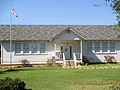
Castor has one school located on Front Street. The complex contains a Pre-K and Kindergarten, elementary, middle, and high school buildings. The current principal is Mrs. Joy-Dee Wallace.

Castor has spawned notable academic achievements. In 2015, three competitors (Sydney Anderson, Kaitlyn Calhoun, and Brittony Cole) in the Future Business Leaders of America National Conference became the first competitors in the parish and Castor High School history to place top 15 in the nation. In 2016, one BETA club member (Mateo Chavez) placed first and third at the state conference and advanced to the national competition. There he placed top ten in both events; seventh in Spelling Division I and first in the nation in Creative Writing. One year later, another Castor High BETA member (Gabrielle Guin) placed second at the state conference in the Handmade Jewelry competition. She qualified and will compete at the national competition. In 2018, at the Future Business Leaders of America State Conference, Mateo Chavez and Brittney Lea made school history. Mateo became the first ever winner of the Richard D Clanton Memorial Scholarship Award from Castor. Brittney Lea won the 2018 Who’s Who in Louisiana FBLA Award. She will be recognized st the National Leadership Conference in Baltimore this summer.

Public transportation

The Council on Aging works in the area to give elderly and disabled means of transportation.

Roads

Running through Castor are three main highways: Hwy 153 (known in Castor as Front Street), Hwy 507 and Hwy 4 which intersect in the middle of Castor at a 4-way-stop caution light. Other roads include The Ridge Rd, Elm St, Pardee St, Oak St, Watson Rd and Lodge St.

Water systems

Castor and the area around has two sources of water: the Castor Water System and the Alberta Water System. The Alberta Water System was founded by local businessman Reginald A. Page.

Media

The primary source of news in Castor is the Shreveport Times . There are also the Ringgold Progress and the Bienville Democrat, which is published in Arcadia.

Cable television does not reach into Castor area. Viewers rely on antennas or satellites for coverage.

Economy

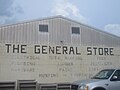
Castor has several businesses: the General Store, a gasoline station, flower shop, a cafe, a beauty shop, a laundromat, a branch of the Bank of Montgomery (formerly Bank of Ringgold), United States Post Office, retirement homes, and a mobile home park. The majority of working adults commute to one of the more urban areas nearby for employment.

Notable people

Related Research Articles

<span class="mw-page-title-main">Webster Parish, Louisiana</span> Parish in Louisiana, United States

Webster Parish is a parish located in the northwestern section of the U.S. state of Louisiana. The seat of the parish is Minden.

<span class="mw-page-title-main">Bienville Parish, Louisiana</span> Parish in Louisiana, United States

Bienville Parish is a parish located in the northwestern portion of the U.S. state of Louisiana. At the 2020 census, the population was 12,981. The parish seat is Arcadia.

<span class="mw-page-title-main">Arcadia, Louisiana</span> Town in Louisiana, United States

Arcadia is a town in, and the parish seat of, Bienville Parish in northern Louisiana, United States. The population was 2,919 at the 2010 census. Arcadia has the highest elevation of any incorporated municipality in Louisiana. Arcadia's name commemorates the Ancient Greek region of Arcadia.

<span class="mw-page-title-main">Bienville, Louisiana</span> Village in Louisiana, United States

Bienville is a village in Bienville Parish, Louisiana, United States. The population was 218 at the 2010 census.

<span class="mw-page-title-main">Bryceland, Louisiana</span> Village in Louisiana, United States

Bryceland is a village in Bienville Parish, Louisiana, United States. The population was 108 at the 2010 census.

<span class="mw-page-title-main">Jamestown, Louisiana</span> Village in Louisiana, United States

Jamestown is a village in Bienville Parish, Louisiana, United States. The population was 139 at the 2010 census and 130 in 2017.

<span class="mw-page-title-main">Lucky, Louisiana</span> Village in Louisiana, United States

Lucky is a village in Bienville Parish, Louisiana, United States. The population was 272 at the 2010 census.

<span class="mw-page-title-main">Mount Lebanon, Louisiana</span> Town in Louisiana, United States

Mount Lebanon is a town in Bienville Parish, Louisiana, United States. The population was 83 at the 2010 census.

<span class="mw-page-title-main">Ringgold, Louisiana</span> Town in Louisiana, United States

Ringgold is a town in the U.S. state of Louisiana, in the western half of Bienville Parish. The town of Ringgold is named for United States Army Major Samuel Ringgold. The population of Ringgold was 1,495 at the 2010 census, and 1,370 at the U.S. Census Bureau's 2019 estimates, down from 1,601 in 2018. The 2020 U.S. census estimates program recorded a population of 1,336, though the census established a population of 1,379. It is the second largest incorporated municipality in Bienville Parish by population.

<span class="mw-page-title-main">Saline, Louisiana</span> Village in Louisiana, United States

Saline is a village in southeastern Bienville Parish, Louisiana, United States. The population was 277 at the 2010 census. Saline is pronounced "Suh-LEEN".

<span class="mw-page-title-main">Haynesville, Louisiana</span> Town in Louisiana, United States

Haynesville is a town in northern Claiborne Parish, Louisiana, United States, located just south of the Arkansas border. The population was 2,039 in 2020.

<span class="mw-page-title-main">Grand Cane, Louisiana</span> Village in Louisiana, United States

Grand Cane is a village in DeSoto Parish, Louisiana, United States. The population was 242 at the 2010 census, up from 191 in 2000. It is part of the Shreveport–Bossier City Metropolitan Statistical Area. It is the hometown of women's basketball pioneer Linda Gamble.

<span class="mw-page-title-main">Montgomery, Louisiana</span> Town in Louisiana, United States

Montgomery is a town in the far northwestern portion of Grant Parish, which is located in north-central Louisiana, United States. The population of Montgomery was 726 at the 2010 census. The town has a poverty rate of 37 percent and a median household income of just under $22,000. The median age is just under forty; the population in 2010 was 78 percent white.

<span class="mw-page-title-main">Quitman, Louisiana</span> Village in Louisiana, United States

Quitman is a village in Jackson Parish, Louisiana, United States. As of the 2010 census, the village population was 181. Quitman is 15 miles (24 km) south of Ruston on U.S. Highway 167, and 9 miles (14 km) north of Jonesboro, the parish seat of Jackson Parish. It is also adjacent to the Jackson Bienville Wildlife Area.

<span class="mw-page-title-main">Choudrant, Louisiana</span> Village in Louisiana, United States

Choudrant is a village in Lincoln Parish, Louisiana, United States. The population was 845 at the 2010 census. It is part of the Ruston Micropolitan Statistical Area.

<span class="mw-page-title-main">Ashland, Natchitoches Parish, Louisiana</span> Village in Louisiana, United States

Ashland is a village in the northernmost portion of Natchitoches Parish, Louisiana, United States. A few residences and a convenience store to the north spill over into neighboring Bienville Parish. The population was 291 at the 2000 census but declined 9 percent to 269 in 2010. The median age was 45.7 years. Ashland is part of the Natchitoches Micropolitan Statistical Area but is located nearly forty miles to the north of the parish seat of Natchitoches.

<span class="mw-page-title-main">Anacoco, Louisiana</span> Village in Louisiana, United States

Anacoco is a village in Vernon Parish, Louisiana, United States. The population was 869 at the 2010 census. It is part of the Fort Polk South Micropolitan Statistical Area.

<span class="mw-page-title-main">Shongaloo, Louisiana</span> City in Louisiana, United States

Shongaloo is a village in Webster Parish, Louisiana, United States.

<span class="mw-page-title-main">Haynesville, Maine</span> Town in the state of Maine, United States

Haynesville is a town in Aroostook County, Maine, United States. The population was 97 at the 2020 census.

<span class="mw-page-title-main">Sullivan, Wisconsin</span> Village in Wisconsin, United States

Sullivan is a village in Jefferson County, Wisconsin, United States. The population was 651 at the 2020 census. The village is located within the Town of Sullivan, and is known to residents of southern Wisconsin including the Madison and Milwaukee metro areas as the location of the National Weather Service forecast office MKX, although its mailing address is in nearby Dousman.

References

  1. "2020 U.S. Gazetteer Files". United States Census Bureau. Retrieved March 20, 2022.
  2. "Castor, LA". zip-codes.com. Retrieved July 5, 2012.
  3. Historical marker, "King's Salt Works", U.S. Post Office in Castor
  4. LOUISIANA TRAILS – Enjoy the Landscape
  5. Mary K. Hamner, "Castor Eastern Star marks 100th anniversary", The Piney Woods Journal, October 2012, pp. 12, 21
  6. MyOilPro.com - Haynesville shale oil & gas leasing in the ark-la-tex
  7. "US Gazetteer files: 2010, 2000, and 1990". United States Census Bureau. 2011-02-12. Retrieved 2011-04-23.
  8. "Census of Population and Housing". Census.gov. Retrieved June 4, 2015.
  9. "U.S. Census website". United States Census Bureau . Retrieved 2008-01-31.

Movie " Arkansas" 2020