Cavenagh Bridge

Last updated
Cavenagh Bridge

加文纳桥
Jambatan Cavenagh
Cavenagh Bridge 3, Dec 05.JPG
Coordinates 1°17′12″N103°51′08″E / 1.28656°N 103.85235°E / 1.28656; 103.85235
CarriesPedestrians and bicycles (vehicles, rickshaws, horse and ox carts in the past)
Crosses Singapore River
Locale Downtown Core, Singapore
Official nameCavenagh Bridge
Characteristics
Design Cable-stayed bridge
Total length79.25 metres
Width9.45 metres
Longest span60.96 metres
History
DesignerColonel Collyer, Rowland Mason Ordish
Constructed byClutha Ironworks and P&W Maclellan, Glasgow Engineers
Opened1869;154 years ago (1869)
Statistics
Designated15 October 2019;4 years ago (2019-10-15)
Reference no.73
Location
Cavenagh Bridge

Cavenagh Bridge is the only suspension bridge and one of the oldest bridges in Singapore, spanning the lower reaches of the Singapore River in the Downtown Core. Opened in 1869 [1] to commemorate Singapore's new Crown colony of the Straits Settlements status in 1867, it is the oldest bridge in Singapore that exists in its original form.

Contents

History

Cavenagh Bridge, P&W Maclellan marker Cavenagh Bridge 2012 0045.jpg
Cavenagh Bridge, P&W Maclellan marker

Originally known as the Edinburgh Bridge to commemorate the visit of the Duke of Edinburgh, its name was changed to Cavenagh Bridge in honour of Major General Orfeur Cavenagh, the last India-appointed Governor of the Straits Settlements, who governed from 1859 to 1867. [2] The coat of arms of the Cavenagh family can still be seen atop the signage at both ends of the bridge.

Cavenagh Bridge linked the Civic District on the northern bank to the Commercial District on the southern bank of the Singapore River. Before Cavenagh Bridge was constructed, people could only move between the two districts via a detour over Elgin Bridge or by paying 1 duitcent) for a boat ride across the river.

This bridge has elaborate suspension struts in comparison with most other suspension bridges, and is the third bridge to be built in Singapore. It was constructed in 1869 to allay the inconvenience of crossing the Singapore River by boat. Numerous steel rivets were used in its construction, which employed steel casting methods commonly used during that era.

The bridge was designed by the colonial Public Works Department's John Turnbull Thomson and constructed by the P&W Maclellan, Glasgow Engineers at a cost of Straits $80,000. Built and tested in Glasgow to withstand a load four times its own weight, it was shipped to Singapore in parts and reassembled in 1869 by convict labour before opening to traffic a year later. Rickshaws and ox carts used the Cavenagh Bridge to cross Singapore River. Subsequently, the bridge became overloaded due to the flourishing trade on the Singapore River in the late 1880s.

The 1910s police notice at each end of the bridge still stands till today. CavenaghSign.JPG
The 1910s police notice at each end of the bridge still stands till today.

When Cavenagh Bridge became unable to cope with the increasing traffic into town and its low draught was insufficient for the passage of boats at high tide, the government decided to build the Anderson Bridge in 1910 to replace Cavenagh Bridge. Cavenagh Bridge was eventually spared from demolition and was converted to a pedestrian bridge, with the road traffic diverted to the Anderson Bridge. A police notice, which is still preserved until today, was thus erected at both ends of the bridge restricting the passage of vehicles that weighed beyond 3 cwt (152 kilograms or 336 pounds), including cattle and horses. The sign reads:

POLICE NOTICE
CAVENAGH BRIDGE
THE USE OF THIS BRIDGE IS PROHIBITED TO ANY VEHICLE OF WHICH THE LADEN WEIGHT EXCEEDS 3 CWT. AND TO ALL CATTLE AND HORSES
BY ORDER
CHIEF POLICE OFFICER.

Cavenagh Bridge today

Night view Hotel The Fullerton y puente Cavenagh, Marina Bay, Singapur, 2023-08-18, DD 36-38 HDR.jpg
Night view

Cavenagh Bridge is currently a pedestrian bridge, with lighting added in 1990 to accentuate its architectural features at nightfall. [2] It now provides the most convenient pedestrian link between the cultural district at the north bank and the commercial district to the south of the Singapore River, and complements the renovated Fullerton Hotel (previously Fullerton Building) which is sited beside the bridge.

There are numerous sculpture works near the Cavenagh Bridge, including a family of Singapura cats (kucinta or drain cats), recognised as one of the smallest breeds of cats in the world, located at the southwest abutment.

On 3 November 2008, the bridge was selected for conservation as part of the Urban Redevelopment Authority's expanded conservation programme. It was subsequently upgraded to a national monument, planned in the early 2010s and announced in 2019 by Deputy Prime Minister Heng Swee Keat. The historical significance is the old police signboard and the physical bridge where Singaporeans had walked past through, even during Lee Kuan Yew's lying-in-state in March 2015. [1] [3] [4] [5]

See also

Listen to this article (1 minute)
Sound-icon.svg
This audio file was created from a revision of this article dated 15 February 2005 (2005-02-15), and does not reflect subsequent edits.

Related Research Articles

<span class="mw-page-title-main">City Hall MRT station</span> Mass Rapid Transit station in Singapore

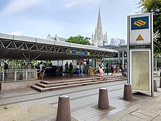
City Hall MRT station is an underground Singapore Mass Rapid Transit (MRT) interchange station on the North–South line (NSL) and East–West line (EWL). Situated in the Downtown Core district, it is underneath Stamford Road near the road junctions with North Bridge Road and St Andrew's Road. The station is near landmarks such as the former City Hall, Raffles City, the Padang, St Andrew's Cathedral and the Cenotaph.

<span class="mw-page-title-main">Raffles Place MRT station</span> Mass Rapid Transit station in Singapore

Raffles Place MRT station is an underground Mass Rapid Transit (MRT) interchange station on the North South Line (NSL) and East West Line (EWL) in Singapore. Located in the Downtown Core, the station is underneath Raffles Place south of the Singapore River. The station serves various landmarks including The Fullerton Hotel, Merlion Park and the Asian Civilisations Museum and various commercial buildings such as One Raffles Place and OCBC Centre.

<span class="mw-page-title-main">Singapore River</span> River in Singapore

The Singapore River is a river that flows parallel to Alexandra Road and feeds into the Marina Reservoir in the southern part of Singapore. The immediate upper watershed of the Singapore River is known as the Singapore River Planning Area, although the western part of the watershed is classified under the River Valley planning area.

National monuments of Singapore are sites, buildings and structures in Singapore that have been designated by the National Heritage Board (NHB) as being of special historic, traditional, archaeological, architectural or artistic value. For historical significance, these buildings are not allowed to be demolished. The Preservation of Monuments Act gives the board authority to order the preservation of such sites and promote research and public interest in the monuments.

<span class="mw-page-title-main">Padang, Singapore</span> A playing field in Singapore

The Padang is an open playing field located within the Downtown Core of the Central Area in Singapore. It includes the Padang Cricket Ground. The Padang is surrounded by several important landmarks, which include Saint Andrew's Cathedral, City Hall, the Old Supreme Court Building and the City Hall MRT station.

<span class="mw-page-title-main">Boat Quay</span> Subzone of Singapore River Planning Area

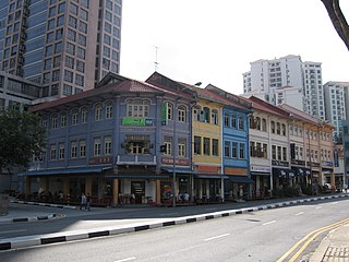
Boat Quay is a historical quay in Singapore which is situated upstream from the mouth of the Singapore River on its southern bank. It spans from the shophouses near UOB Plaza, stretching along one bank of the Singapore River, all the way till Elgin Bridge.

<span class="mw-page-title-main">Elgin Bridge (Singapore)</span> Bridge in Singapore River, Singapore

Elgin Bridge is a vehicular box girder bridge across the Singapore River, linking the Downtown Core to the Singapore River Planning Area located within Singapore's Central Area. It was built between 1925 and 1929.

<span class="mw-page-title-main">Anderson Bridge (Singapore)</span> Bridge in Singapore River, Singapore

Anderson Bridge is a pedestrian bridge that spans across the Singapore River. It is located near the river's mouth in the Downtown Core Planning Area of Singapore's Central Area.

<span class="mw-page-title-main">Lau Pa Sat</span> Historic building in Singapore used as a food centre

Lau Pa Sat, also known as Telok Ayer Market, is a historic building located within the Downtown Core in the Central Area of Singapore. It was first built in 1824 as a fish market on the waterfront serving the people of early colonial Singapore and rebuilt in 1838. It was then relocated and rebuilt at the present location in 1894. It is currently a food court with stalls selling a variety of local cuisine.

<span class="mw-page-title-main">Empress Place Building</span> Historic site in Empress Place

<span class="mw-page-title-main">River Valley, Singapore</span> Planning Area in Central ----, Singapore

River Valley is a planning area located within the Central Area of the Central Region of Singapore. The planning area shares boundaries with Orchard in the north, Museum in the east, Tanglin in the west and Singapore River in the south.

<span class="mw-page-title-main">Chesed-El Synagogue</span> Synagogue in Singapore

The Chesed-El Synagogue is a synagogue in Singapore. The synagogue was constructed in 1905 and is located at Oxley Rise in River Valley, within the Central Area of Singapore.

<span class="mw-page-title-main">National Museum of Singapore</span> National museum of Singapore

The National Museum of Singapore is a public museum dedicated to Singaporean art, culture and history. Located within the country's Civic District at the Downtown Core area, it is the oldest museum in the country. It is one of the largest museums in Asia.

<span class="mw-page-title-main">Civilian War Memorial</span> Monument in Singapore

The Memorial to the Civilian Victims of the Japanese Occupation, usually called the Civilian War Memorial, is a war memorial and heritage landmark in Singapore next to Esplanade MRT station. It was built in memory of the civilians killed during the Japanese occupation of Singapore during World War II. The Civilian War Memorial sits on serene parkland in the midst of busy city traffic near Singapore's Padang and City Hall. Located within the War Memorial Park at Beach Road within the Central Area, Singapore's central business district, it is usually easy to spot in most backdrops encompassing the CBD landscape. It was gazetted as the 65th national memorial on 15 August 2013.

<span class="mw-page-title-main">Tan Kim Seng</span>

Tan Kim Seng, was a prominent Straits-born Chinese merchant and philanthropist in Singapore in the 19th century.

<span class="mw-page-title-main">Connaught Drive</span> Road in Singapore

Connaught Drive is a one-way road linking Stamford Road to Fullerton Road on the northern side of the Singapore River within the Downtown Core in Singapore. Esplanade Park is on the left side of the road, and The Padang is on the right. Before the Esplanade Bridge was opened in 1997, the road was used by vehicles from Marina Centre and Nicoll Highway to cross the Singapore River. The road is still used by several bus services and as a car park on both sides of the road as well as for coach parking.

<span class="mw-page-title-main">Museum Planning Area</span> Planning Area in Central Region ----, Singapore

The Museum Planning Area is a planning area located in the Central Area of the Central Region of Singapore. The area plays a "bridging role" between the Orchard area and the Downtown Core, which necessitates proper transport networks for vehicles, pedestrians and public transport. Due to the sheer size of green areas in the district, the Urban Redevelopment Authority (URA) has designated it a 'green lung' in the Central Area. However, the Museum Planning Area is also home to cultural and commercial activities. Around 65% of the area is available for future development, making it a hotbed for new infrastructure and buildings.

<span class="mw-page-title-main">The Fullerton Hotel Singapore</span> Hotel in Singapore

The Fullerton Hotel Singapore is a five-star luxury hotel located near the mouth of the Singapore River, in the Downtown Core of the Central Area, Singapore. It was originally known as the Fullerton Building, and also as the General Post Office Building. The address is 1 Fullerton Square. The Fullerton Building was named after Robert Fullerton, the first Governor of the Straits Settlements (1826–1829). Commissioned in 1924 as part of the British colony's centennial celebrations, the building was designed as an office building by Major P.H. Keys of Keys & Dowdeswell, a Shanghai firm of architects, which won the project through an architectural design competition. The architectural firm also designed the Capitol Theatre, its adjoined Capitol Building and the Singapore General Hospital. In 2015, it was designated as a national monument of Singapore.

<span class="mw-page-title-main">Tan Kim Seng Fountain</span>

The Tan Kim Seng Fountain is a fountain in Singapore that was erected in 1882 in honor of notable philanthropist Tan Kim Seng for his donations for the Singapore's first reservoir and waterworks.

References

  1. 1 2 "Singapore River Bridges gazetted as Singapore's 73rd National Monument" (PDF). NHB. 15 October 2019. Retrieved 26 October 2019.
  2. 1 2 G. Chandradas, Tien Chung Ping (21 August 2008). "Bridging the gap", The Straits Times.
  3. Ang, Prisca (15 October 2019). "Another $15 million in restoration funds for owners of national monuments". The Straits Times. Retrieved 24 October 2019.
  4. "Singapore River Bridges and the Padang to be gazetted as National Monuments" (PDF). NHB. 3 August 2019. Retrieved 26 October 2019.
  5. "Padang, Singapore River Bridges to be gazetted as national monuments". CNA. 3 August 2019. Archived from the original on 6 August 2019. Retrieved 24 October 2019.