Cerro Pedernal

Last updated
Cerro Pedernal
Pedernal Mountain, NM.jpg
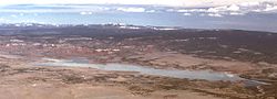
Pedernal viewed from Ghost Ranch
Highest point
Elevation 9,866 ft (3,007 m)  NAVD 88 [1]
Prominence 1,362 ft (415 m) [2]
Coordinates 36°09′48″N106°30′14″W / 36.16323126°N 106.50380896°W / 36.16323126; -106.50380896 [1]
Geography
USA New Mexico relief location map.svg
Red triangle with thick white border.svg
Cerro Pedernal
Location in New Mexico
Location Rio Arriba County, New Mexico, U.S.
Parent range Jemez Mountains
Topo map USGS Youngsville

Cerro Pedernal, (Tewa: Tsip'in) locally known as just "Pedernal", is a narrow mesa in northern New Mexico. [3] The name is Spanish for "flint hill". The mesa lies on the north flank of the Jemez Mountains, south of Abiquiu Lake, in the Coyote Ranger District of the Santa Fe National Forest. Its caprock was produced in the Jemez Volcanic Field. Its highest point is at 9,862 feet (3,006 meters).

Pedernal is the source of a chert used by the prehistoric Gallina people. Its cliffs are popular with rock climbers. Georgia O'Keeffe made many paintings of it, and her ashes were scattered on its top. [4]

The Tewa name of the mountain is Tsip’in (tsi’i, obsidian; p’in, mountain). The Cochiti name is Hest'e'yanyik'othe (hest'e'yanyi, obsidian; k'othe, mountain). [3]

Pedernal Coyote1.jpg
From near Coyote, New Mexico, in summer monsoon weather
Pedernal Youngsville1.jpg
From Youngsville, New Mexico, also in monsoon weather
AbiquiuLakeNM.jpg
View from summit in winter, looking north. Abiquiu Lake in foreground; Tusas Mountains on horizon

Related Research Articles

<span class="mw-page-title-main">Puebloans</span> Native Americans in the Southwestern United States

The Puebloans, or Pueblo peoples, are Native Americans in the Southwestern United States who share common agricultural, material, and religious practices. Among the currently inhabited Pueblos, Taos, San Ildefonso, Acoma, Zuni, and Hopi are some of the most commonly known. Pueblo people speak languages from four different language families, and each Pueblo is further divided culturally by kinship systems and agricultural practices, although all cultivate varieties of maize.

<span class="mw-page-title-main">Española, New Mexico</span> City in New Mexico, United States

Española is a city primarily in Rio Arriba County, New Mexico, United States. A portion of the central and eastern section of the city is in Santa Fe County. Founded as a railroad village some distance from the old Indian town of San Juan de los Caballeros, it was named Española and officially incorporated in 1925. It has been called the first capital city in the United States. At the time of the 2010 census, the city had a total population of 10,495. Española is within the Albuquerque–Santa Fe–Las Vegas combined statistical area.

<span class="mw-page-title-main">Valles Caldera</span> Volcanic caldera in the Jemez Mountains of northern New Mexico, United States

Valles Caldera is a 13.7-mile (22.0 km) wide volcanic caldera in the Jemez Mountains of northern New Mexico. Hot springs, streams, fumaroles, natural gas seeps and volcanic domes dot the caldera floor landscape. The highest point in the caldera is Redondo Peak, an 11,253-foot (3,430 m) resurgent lava dome located entirely within the caldera. Also within the caldera are several grass valleys, or valles, the largest of which is Valle Grande, the only one accessible by a paved road. In 1975, Valles Caldera was designated as a National Natural Landmark by the National Park Service with much of the caldera being within the Valles Caldera National Preserve, a unit of the National Park System.

<span class="mw-page-title-main">Bandelier National Monument</span> United States historic place

Bandelier National Monument is a 33,677-acre (13,629 ha) United States National Monument near Los Alamos in Sandoval and Los Alamos counties, New Mexico. The monument preserves the homes and territory of the Ancestral Puebloans of a later era in the Southwest. Most of the pueblo structures date to two eras, dating between 1150 and 1600 AD.

<span class="mw-page-title-main">Tewa</span> Ethnic group of Pueblo Native Americans

The Tewa are a linguistic group of Pueblo Native Americans who speak the Tewa language and share the Pueblo culture. Their homelands are on or near the Rio Grande in New Mexico north of Santa Fe. They comprise the following communities:

<span class="mw-page-title-main">Puye Cliff Dwellings</span> United States historic place

The Puye Cliff Dwellings are the ruins of an abandoned pueblo, located in Santa Clara Canyon on Santa Clara Pueblo Reservation land near Española, New Mexico. Established in the late 1200s or early 1300s and abandoned by about 1600, this is among the largest of the prehistoric Indian settlements on the Pajarito Plateau, showing a variety of architectural forms and building techniques.

<span class="mw-page-title-main">Jemez Mountains</span> Mountain range in New Mexico, United States

The Jemez Mountains are a group of mountains in Rio Arriba, Sandoval, and Los Alamos counties, New Mexico, United States.

<span class="mw-page-title-main">Chicoma Mountain</span> Mountain in New Mexico, United States

Chicoma Mountain is the highest point in the Jemez Mountains, a prominent mountain range in the U.S. State of New Mexico. The tree line in this area is exceptionally high, and the mountain is forested almost all the way to its summit which is conspicuous from the towns of Los Alamos, Santa Fe, and Española and other areas in the valley of the Rio Grande in northern New Mexico. Like the rest of the Jemez, it is of volcanic origin; it lies on the northeast rim of the Valles Caldera, one of the best examples of a caldera in the United States.

<span class="mw-page-title-main">Redondo Peak</span>

Redondo Peak is a conspicuous summit in the Jemez Mountains of New Mexico, in the southwestern United States. It is located entirely within the Valles Caldera National Preserve. It is the second highest summit in the Jemez after Chicoma Mountain. It is the most visually prominent peak in the range when viewed from the south, for example, from Albuquerque. From many other directions it is less prominent or not visible, due to its location in the center of the Valles Caldera, well away from the caldera's rim.

<span class="mw-page-title-main">Tsankawi</span> Archeological site in New Mexico, United States

Tsankawi is a detached portion of Bandelier National Monument near White Rock, New Mexico. It is accessible from a roadside parking area, just north of the intersection of East Jemez Road and State Road 4. A self-guided 1.5-mile loop trail provides access to numerous unexcavated ruins, caves carved into soft tuff, and petroglyphs.

<span class="mw-page-title-main">Cerro Grande Fire</span> Wildfire in New Mexico, United States

The Cerro Grande Fire was a prescribed forest fire in Los Alamos, New Mexico, United States of America, that occurred in May of 2000. The fire started as a controlled burn, and became uncontrolled owing to high winds and drought conditions. Over 400 families in the town of Los Alamos, New Mexico, lost their homes in the resulting 43,000-acre (170 km2) fire. Structures at Los Alamos National Laboratory were also destroyed or damaged, although without loss or destruction of any of the special nuclear material housed there. No loss of human life occurred. The US General Accounting Office estimated total damages at $1 billion.

<span class="mw-page-title-main">Albuquerque metropolitan area</span> Metropolitan area in central New Mexico

The Albuquerque Metropolitan Statistical Area, sometimes referred to as Tiguex, is a metropolitan area in central New Mexico centered on the city of Albuquerque. The metro comprises four counties: Bernalillo, Sandoval, Torrance, and Valencia. As of the 2010 United States Census, the MSA had a population of 887,077. The population is estimated to be 923,630 as of July 1, 2020, making Greater Albuquerque the 61st-largest MSA in the nation. The Albuquerque MSA forms a part of the larger Albuquerque–Santa Fe–Las Vegas combined statistical area with a 2020 estimated population of 1,165,181, ranked 49th-largest in the country.

<span class="mw-page-title-main">Gallina</span>

The Gallina or Largo-Gallina culture was an occupation sequence during the pre-Hispanic period in the American Southwest from approximately 1050 to 1300. The culture was located in north-central New Mexico roughly north of the Jemez Mountains, and was named after the Rio Gallina, which runs through the region.

New Mexico State Road 4 (NM 4) is a 67.946-mile-long (109.348 km) state highway in Sandoval, Los Alamos, and Santa Fe counties in New Mexico, United States. It is significant as the main access route connecting the remote town of Los Alamos, Los Alamos National Laboratory, and Bandelier National Monument to other, more major highways in New Mexico.

<span class="mw-page-title-main">Los Alamos, New Mexico</span> Census-designated place in New Mexico, United States

Los Alamos is a census-designated place in Los Alamos County, New Mexico, United States, that is recognized as one of the development and creation places of the atomic bomb—the primary objective of the Manhattan Project by Los Alamos National Laboratory during World War II. The town is located on four mesas of the Pajarito Plateau, and had a population of about 13,200 as of 2020. It is the county seat and one of two population centers in the county known as census-designated places (CDPs); the other is White Rock.

<span class="mw-page-title-main">Zia Formation</span> Rock formation in New Mexico

The Zia Formation is a geologic formation in the southwestern Jemez Mountains and northwestern Santo Domingo basin. It contains vertebrate fossils that date it to early to middle Miocene in age.

<span class="mw-page-title-main">Polvadera Group</span> A group of geologic formations in New Mexico

The Polvadera Group is a group of geologic formations exposed in and around the Jemez Mountains of northern New Mexico. Radiometric dating gives it an age of 13 to 2.2 million years, corresponding to the Miocene through early Quaternary.

<span class="mw-page-title-main">Keres Group</span> A group of geologic formations in New Mexico

The Keres Group is a group of geologic formations exposed in and around the Jemez Mountains of northern New Mexico. Radiometric dating gives it an age of 13 to 6 million years, corresponding to the Miocene epoch.

<span class="mw-page-title-main">Tewa Group</span> A group of geologic formations in New Mexico

The Tewa Group is a group of geologic formations exposed in and around the Jemez Mountains of northern New Mexico. Radiometric dating gives it an age of 1.85 million to 72 thousand years, corresponding to the Pleistocene epoch.

<span class="mw-page-title-main">Atalaya Mountain (Santa Fe County, New Mexico)</span>

Atalaya Mountain is a mountain peak located within the Santa Fe National Forest, in northern New Mexico, United States. It is part of the Santa Fe Mountains in the Sangre de Cristo Range, a subrange of the Southern Rocky Mountains. A relevant viewscape from the city of Santa Fe, there are no higher peaks between the city and Atalaya Mountain to the east. Viewed from the city, Atalaya Mountain is framed by Sun Mountain to the right (south), Picacho Peak to the left (north), and Thompson Peak behind it. Atalaya Mountain is accessible by following the Atalaya Trail, or via the Dale Ball Trails from the direction of Picacho Peak and trail marker number 36.

References

  1. 1 2 "Dernal". NGS Data Sheet. National Geodetic Survey, National Oceanic and Atmospheric Administration, United States Department of Commerce . Retrieved 2014-02-15.
  2. "Cerro Pedernal, New Mexico". Peakbagger.com. Retrieved 2014-02-15.
  3. 1 2 Harrington, J. P. (1920). "Old Indian Geographical Names around Santa Fe, New Mexico". American Anthropologist. 22 (4): 341–359. ISSN   0002-7294.
  4. Gómez, Art (2004). New Mexico: Images of a Land and its People. UNM Press. p. 61. ISBN   0-8263-3257-9 . Retrieved 2011-08-06.