This article needs additional citations for verification .(February 2008) |
Chaflin Bridge, Illinois | |
|---|---|
| Etymology: Isaac Chaflin, early settler | |
 Chaflin Bridge  Chaflin Bridge | |
| Coordinates: 38°12′43″N90°16′07″W / 38.21194°N 90.26861°W | |
| Country | United States |
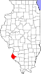
| State | Illinois |
| County | Monroe |
| Precinct | 15 |
| Elevation | 400 ft (120 m) |
| Time zone | UTC-6 (CST) |
| • Summer (DST) | UTC-5 (CDT) |
| Postal code | 62244 |
| Area code | 618 |
Chaflin Bridge is an unincorporated community in the historic Mitchie Precinct of Monroe County, Illinois, United States. It lies on the old Bluff Road in the American Bottoms between Fults and the old site of Valmeyer and near Maeystown.