
St. Clair County is the ninth most populous county in Illinois, located in the southwestern part of the state along the Mississippi River bordering Missouri. Located directly east of St. Louis, the county is part of the Metro East region of the Greater St. Louis metropolitan area. As of the 2020 United States census, St. Clair County had a population of 257,400, making it the third most populous county in Illinois outside the Chicago metropolitan area. Belleville is the county’s seat and largest city.

Monroe County is a county located in the U.S. state of Illinois. According to the 2020 census, it had a population of 34,962. Its county seat and largest city is Waterloo.
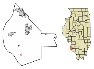
Fults is a village in the Renault precinct of Monroe County, Illinois, United States. The population was 28 at the 2020 census. It is located entirely within the American Bottom floodplain of the Mississippi River.

Kaskaskia is a village in Randolph County, Illinois. Having been inhabited by indigenous peoples, it was settled by France as part of the Illinois Country. It was named for the Kaskaskia people. Its population peaked at about 7,000 in the 18th century, when it was a regional center. During the American Revolutionary War, the town, which by then had become an administrative center for the British Province of Quebec, was taken by the Virginia militia during the Illinois campaign. It was designated as the county seat of Illinois County, Virginia, after which it became part of the Northwest Territory in 1787. Kaskaskia was later named as the capital of the United States' Illinois Territory, created on February 3, 1809. In 1818, when Illinois became the 21st U.S. state, the town briefly served as the state's first capital until 1819, when the capital was moved to more centrally located Vandalia.

The history of Missouri begins with settlement of the region by indigenous people during the Paleo-Indian period beginning in about 12,000 BC. Subsequent periods of native life emerged until the 17th century. New France set up small settlements, and in 1803, Napoleonic France sold the area to the U.S. as part of the Louisiana Purchase. Statehood for Missouri came following the Missouri Compromise in 1820 that allowed slavery. Settlement was rapid after 1820, aided by a network of rivers navigable by steamboats, centered in the City of St. Louis. It attracted European immigrants, especially Germans; the business community had a large Yankee element as well. The Civil War saw numerous small battles and control by the Union. After the war, its economy diversified, and railroads centered in Kansas City, opened up new farmlands in the west.

Southern Illinois, also known as Little Egypt, is the southern third of Illinois, principally along and south of Interstate 64. Although part of a Midwestern state, this region is aligned in culture more with that of the Upland South than the Midwest. Part of downstate Illinois, it is bordered by the two most voluminous rivers in the United States: the Mississippi below its connecting Missouri River to the west and the Ohio River to the east and south with the Wabash as tributary.

The Illinois Country —sometimes referred to as Upper Louisiana —was a vast region of New France claimed in the 1600s in what is now the Midwestern United States. While these names generally referred to the entire Upper Mississippi River watershed, French colonial settlement was concentrated along the Mississippi and Illinois Rivers in what is now the U.S. states of Illinois and Missouri, with outposts in Indiana. Explored in 1673 from Green Bay to the Arkansas River by the Canadien expedition of Louis Jolliet and Jacques Marquette, the area was claimed by France. It was settled primarily from the Pays d'en Haut in the context of the fur trade, and in the establishment of missions by French Catholic religious orders. Over time, the fur trade took some French to the far reaches of the Rocky Mountains, especially along the branches of the broad Missouri River valley. The French name, Pays des Ilinois, means "Land of the Illinois [plural]" and is a reference to the Illinois Confederation, a group of related Algonquian native peoples.
John Wood was the 12th governor of Illinois, serving from March 18, 1860, to January 14, 1861. Wood was a founder and the first settler of Quincy, Illinois.
Louisiana or French Louisiana was an administrative district of New France. Under French control from 1682 to 1769 and 1801 (nominally) to 1803, the area was named in honor of King Louis XIV, by French explorer René-Robert Cavelier, Sieur de la Salle. It originally covered an expansive territory that included most of the drainage basin of the Mississippi River and stretched from the Great Lakes to the Gulf of Mexico and from the Appalachian Mountains to the Rocky Mountains.

The American Bottom is the flood plain of the Mississippi River in the Metro-East region of Southern Illinois, extending from Alton, Illinois, south to the Kaskaskia River. It is also sometimes called "American Bottoms". The area is about 175 square miles (450 km2), mostly protected from flooding in the 21st century by a levee and drainage canal system. Immediately across the river from St. Louis, Missouri, are industrial and urban areas, but nearby marshland, swamps, and the Horseshoe Lake are reminders of the Bottoms' riparian nature.
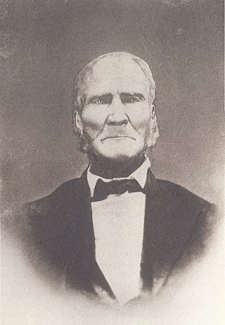
Samuel Whiteside was an Illinois pioneer. A farmer and backwoodsman, Whiteside briefly served in the Illinois General Assembly after statehood and led the Illinois militia for decades, rising to the rank of general but also enlisting as an ordinary soldier when militia calls declined at the end of wars. Whiteside fought the British in the War of 1812 and Native Americans through the Blackhawk War.
The history of large-scale slavery in the region which later became the State of Missouri began in 1720, when a French merchant named Philippe François Renault brought about 500 slaves of African descent from Saint-Domingue up the Mississippi River to work in lead mines in what is now southeastern Missouri and southern Illinois. These people were the first enslaved Africans brought en masse to the middle Mississippi River Valley. Prior to Renault's enterprise, slavery in Missouri under French colonial rule had been practiced on a much smaller scale as compared to elsewhere in the French colonies.
Philippe François Renault was a French politician, businessman, explorer, metallurgist, and favorite courtier of King Louis XV of France, who left his native Picardy in 1719 for the Illinois Country, Upper Louisiana, in French North America.
Harrisonville is an unincorporated community in the historic Harrisonville Precinct of Monroe County, Illinois.

Missouri French or Illinois Country French also known as français vincennois, français Cahok, and nicknamed "Paw-Paw French" often by individuals outside the community but not exclusively, is a variety of the French language spoken in the upper Mississippi River Valley in the Midwestern United States, particularly in eastern Missouri.
Old Mines is the name of an unincorporated community and surrounding area in southeast Missouri that were settled by French colonists in the early 18th century when the area was part of the Illinois Country of New France. The early settlers came to mine for lead, and their descendants still inhabit the area where, through a combination of geographic and cultural isolation, they maintained a distinctive French culture well into the 20th century. As recently as the late 1980s there may have been a thousand native speakers of the region's Missouri French dialect. This culturally distinct population has sometimes been referred to as "paw-paw French" and lives in an amorphous area in Washington, Jefferson, and St. Francois counties roughly 15 miles (24 km) either side of a line from Potosi to De Soto. The community of Old Mines itself is in northeastern Washington County, six miles north of Potosi.
St. Philippe is a former village in Monroe County, Illinois, United States. The settlement was founded in ca. 1723 by Frenchman, Philip Francois Renault, during the French colonial period. St. Philippe was strategically located near the bluffs that flank the east side of the Mississippi River in the vast Illinois floodplain known as the "American Bottom". The village was located three miles north of Fort de Chartres. Because of many decades of severe seasonal flooding, St. Philippe and the fort were both abandoned before 1765. After the British takeover of this area following their victory in the Seven Years War, many French from the Illinois country moved west to Ste. Genevieve, Saint Louis, and Missouri
The history of St. Louis, Missouri, from prehistory to 1762 was marked by the presence of the Moundbuilder indigenous culture, the explorations of Europeans, and the establishment of French trading posts along the Mississippi River.
The Colonial history of Missouri covers the French and Spanish exploration and colonization: 1673–1803, and ends with the American takeover through the Louisiana Purchase
The French Louisianians, also known as Louisiana French, are Latin French people native to the states that were established out of French Louisiana. They are commonly referred to as French Creoles. Today, the most famous Louisiana French groups are the Alabama Creoles, Louisiana Creoles, and the Missouri French.


