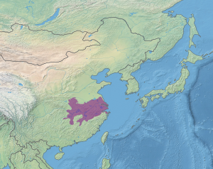
Changjiang Plain evergreen forests

Last updated
Changjiang Plain evergreen forests
Hukou Shizhongshan 2019.04.27 09-10-44.jpg
River traffic on Yangtze River and Poyang Lake
Ecoregion PA0415.svg
Ecoregion territory (in purple)
Ecology
Realm Palearctic
Biome Temperate broadleaf and mixed forest
Geography
Area437,967 km2 (169,100 sq mi)
Countries China
Coordinates 30°30′N117°45′E / 30.500°N 117.750°E / 30.500; 117.750

The Changjiang Plain evergreen forests ecoregion (WWF ID: PA0415) covers the plain of the Yangtze River (Changjiang) from where it leaves the mountains at the Three Gorges in the west, to the mouth of the Yangtze at the East China Sea. This plain is one of the most densely populated areas on Earth, and most of the original oak and conifer forests have long been converted to agriculture. Extensive wetlands, however, provide habitat for migratory waterfowl and for diverse aquatic species. [1] [2]

Contents

Location and description

The Yangtze River Plain stretches 1,000 km from the Three Gorges to the sea. The terrain is mostly flat or low alluvial hills, with numerous shallow lakes. Large lakes include Poyang Lake, the largest freshwater lake in China, and Dongting Lake which was formerly the largest but has seen significant conversion to farmland over the years. The floodplain lakes grow and shrink dramatically with the seasons - Dongting Lake grows from 3,700 km2 to 13,000 km2 in the summer (and its depth increases by 10 meters).

Climate

The climate of the ecoregion is Humid subtropical climate, warm wet summer (Köppen climate classification (Cfa)). This climate is characterized by large seasonal temperature differentials. No month averages below 0 °C (32 °F), at least one month averages above 22 °C (72 °F), and four months average over 10 °C (50 °F). Precipitation is relatively even throughout the year. [3] [4]

Flora and fauna

Wetlands in Poyang Lake National Wetland Park Poyang Baishazhou 2017.11.25 14-42-59.jpg
Wetlands in Poyang Lake National Wetland Park

The plain was once home to extensive evergreen oak (Cyclobalanopsis) or chinquapin ( Castanopsis ) forests, but the flat areas have mostly been converted to rice paddies. Better drained hills once supported conifers, but these areas are now mostly scrub or developed. Seasonal flooding of the river and surrounding wetlands provide habitat for waterfowl and aquatic life.

Aquatic life includes endangered species, such as the Chinese sturgeon ( Acipenser sinensis ) and the Chinese alligator ( Alligator sinensis ).

See also

Related Research Articles

<span class="mw-page-title-main">Pleshcheyevo Ozero National Park</span>

Pleshcheyovo Ozero (Lake) National Park covers Lake Pleshcheyevo and surrounding areas in the Zalesye part of the Yaroslavl Oblast. The lake is highly popular for recreational use, as an ecological habitat, and is a former resort for the Russian tsars. The lake is located on the central part of the East European Plain, about 130 km northeast of Moscow, in the basin of the Upper Volga. On the southeast shore is the old town of Pereslavl-Zalessky, included in the Golden Ring of Russia.

<span class="mw-page-title-main">Smolenskoye Poozerye National Park</span>

Smolenskoye Poozerye National Park is a forest-wetland ecosystem of 35 lakes and surroundings in the northwest of Smolensk Oblast near the Russian border with Belarus, about 40 miles (64 km) north of the city of Smolensk. The Western Dvina River flows through the lake region. The park was officially established in 1992. Since 2002, the park has been included in the international network of biosphere reserves. Administratively, the national park is shared between Demidovsky and Dukhovshchinsky Districts of Smolensk Oblast.

<span class="mw-page-title-main">Khingan Nature Reserve</span> Strict nature reserve in Amur Oblast, Russia

Khingan Nature Reserve is a Russian 'zapovednik', located in the extreme south-east of the Amur River region of the Russian Far East. The reserve covers two types of habitat: the flat Arkharinskaya lowlands with abundant wetlands, and forested spurs of the Lesser Khingan mountains. In particular, Khingan Reserve was created to protect steppe and forest-steppe landscapes, and nesting sites of the endangered Red-crowned crane and the vulnerable White-naped crane. The reserve is situated in the Arkharinsky District of Amur Oblast.

<span class="mw-page-title-main">Bolon Nature Reserve</span> Nature reserve in Khabarovsk Krai, Russia

Bolon Nature Reserve is the oldest Russian 'zapovednik' in the Russian Far East. It is located on the Middle Amur River lowlands adjacent to the south-west of Lake Bolon. The reserve covers the wetlands of international importance. Large numbers of migratory waterfowl use the area for nesting and stopovers on long flights. The reserve is situated half way between the city of Khabarovsk and Komsomolsk-on-Amur, in the Amursky District of Khabarovsk Krai. The reserve was created in 1997, and covers an area of 100,000 ha (390 sq mi).

<span class="mw-page-title-main">Nora Nature Reserve</span> Nature reserve in Amur Oblast, Russia

Nora Nature Reserve is a Russian 'zapovednik' on the northeastern part of the Amur-Zeya lowland plain between the Nora River and the Selemdzha River. The reserve is known for its herd of Norsk roe deer, the largest migrating herd in the world, with 5,000-7,000 individuals migrating through every September. The terrain is half forested, and half wetland and bogs, in the meeting zone between Siberian, Okhotsk, and Mongolian plant and animal communities. The reserve is situated in the Selemdzhinsky District of Amur Oblast.

Prisurski Nature Reserve is a Russian zapovednik in the northern Volga Uplands of the East European Plain. It protects for study an area of forest-steppe and mixed forest, with sections in different parts of Chuvashia. The largest sector is the Alatyrski Nature Reserve, located in the valley of the Sura River, and two small steppe sections to the southeast. The reserve is situated in the Alatyr, Chuvash Republic District of the Chuvash Republic. It was set aside as a reserve in 1995 to protect the largest and least disturbed area of southern taiga lowland forest in Chuvashia, as well as steppe habitat at the northern edge of its range. A particular concern was protecting habitat of the muskrat and seasonal waterfowl. The reserve covers an area of 9,150 ha (35.3 sq mi).

<span class="mw-page-title-main">Pryazovskyi National Nature Park</span> National park in Ukraine

Pryazovskyi National Nature Park is the second largest national park of Ukraine, covering the estuaries, coastal plains seaside landforms around the Molochna River estuary the Utlyuksky estuary, on the northwest coast of the Sea of Azov. The area is one of high biodiversity, protecting both steppe and aquatic habitats, and the unique transition zones in between. The wetlands support very large populations of nesting and migratory waterfowl. The park is crosses several administrative districts, including Pryazovske Raion, Melitopol Raion, Berdiansk Raion, and Yakymivka Raion in Zaporizhzhia Oblast.

<span class="mw-page-title-main">Lower Sula National Nature Park</span> National park in Ukraine

Lower Sula National Nature Park is a national park of Ukraine that covers the lower reaches of the Sula River as it enters the Kremenchuk Reservoir, 120 km southeast of Kyiv. The extensive marshes, swamps, and other wetlands of the area are important habitats for fish, waterfowl, and floodplain plants. The park is administratively in the Kremenchuk, Orzhytsia, and Semenivka raions of Poltava Oblast, and Zolotonosha Raion of Cherkasy Oblast.

<span class="mw-page-title-main">Northeast China Plain deciduous forests</span> Ecoregion in Northeast China

The Northeast China Plain deciduous forests ecoregion covers the flat interior Northeast China Plain and neighboring adjacent northwestern North Korea, in the region historically known as Manchuria. The plain is surrounded by mountains on the north and east, and supports some of China's largest forest tracts. There are also extensive low-lying wetlands, which support important bird populations.

<span class="mw-page-title-main">Changbai Mountains mixed forests</span> Ecoregion in China and North Korea

The Changbai Mountains mixed forests ecoregion covers the Changbai Mountains and surrounding foothills in China and North Korea. The region features extensive and naturally preserved deciduous and conifer forests. The region exhibits high biodiversity due to its relative isolation, temperate climate with high rainfall, and centrality to central Chinese, Siberian, and European floral communities. In 1979, a significant portion of the ecoregion was designated the Changbaishan Biosphere Reserve by UNESCO.

<span class="mw-page-title-main">Nenjiang River grassland</span> Ecoregion in the Nen river basin

The Nenjiang River grassland ecoregion covers the low wetlands of the lower Nen River in northeast China. The region is known for supporting migratory and permanent nesting populations of a variety of migratory waterfowl, including six species of crane.

<span class="mw-page-title-main">South China–Vietnam subtropical evergreen forests</span> Ecoregion in South China and Vietnam

The South China-Vietnam subtropical evergreen forests ecoregion covers the mountainous coastal region of southeastern China and northeastern Vietnam. The ecoregional also covers the coastal plain along the South China Sea and Hainan Island. The area has significant biodiversity and ecological importance, with high levels of both endemic and threatened species. Rapid urban expansion is reducing biologically-rich forests and wetlands. Ecologically, the subtropical forests are at the northeastern extent of the Indomalayan realm.

<span class="mw-page-title-main">Qin Ling Mountains deciduous forests</span> Ecoregion in Central China

The Qin Ling Mountains deciduous forests ecoregion covers the Qin Mountains, which run west-to-east across central China. The mountains effectively divide the biological regions of China into north and south. To the north is the Yellow River basin, a loess-soil region of temperate deciduous forests. To the south is the Yangtze River basic, a subtropical forest region. In between, the Qin Mountains support many rare and endemic species, including the Giant panda and the Sichuan snub-nosed monkey.

<span class="mw-page-title-main">Jiang Nan subtropical evergreen forests</span> Ecoregion in Southern China

The Jiang Nan subtropical evergreen forests ecoregion covers the mountainous divide between the lower Yangtze River and the coastal plain of South China. The region is also a climatic divide between the temperate valleys of the north and the subtropical forests of the south. The region is important for biodiversity and endemic species. The rugged limestone karst hills have been relatively protected from conversion to agriculture, and support specialized plant and animal communities.

<span class="mw-page-title-main">Manchurian mixed forests</span> Ecoregion in Korea, China, and Russia

The Manchurian mixed forests ecoregion covers the forested hills surrounding the river plains of northern China, Russia, North Korea, and South Korea. The ecoregion supports a number of rare species due to the relative isolation, the diversity of habitat, with mixed forests of deciduous Mongolian oak and conifers of Korean pine. Because mountains rise above the region on three sides, with plains and wetlands below, the area supports high biodiversity as a transition zone.

<span class="mw-page-title-main">Altai steppe and semi-desert</span> Ecoregion in the Altai Mountains

The Altai steppe and semi-desert ecoregion, as its name indicates, sits in a transition zine between steppe and semi-desert, supporting sparse grass and shrublands. The area is relatively undeveloped, with agriculture mostly represented by grazing livestock. There are a few shallow lakes in depressions used by migratory birds.

<span class="mw-page-title-main">Hokkaido deciduous forests</span> Ecoregion in Hokkaidō, Japan

The Hokkaidō deciduous forests ecoregion covers the northern and southern coasts of the island of Hokkaido, the northernmost of the main islands of Japan. The region sits in the transition zone between the colder subarctic forests to the north and the more temperate forests to the south. Characteristic trees include Mongolian oak, Basswood, and Ash trees.

<span class="mw-page-title-main">Tonle Sap freshwater swamp forests</span> Ecoregion in Cambodia and Southern Vietnam

The Tonle Sap freshwater swamp forests ecoregion covers the seasonally flooded forests surrounding Tonlé Sap, the largest lake in Cambodia, and the floodplains of its connections to the Mekong River. Over 35% of the ecoregion experiences flooding during the wet season.

<span class="mw-page-title-main">Northern Triangle subtropical forests</span>

The Northern Triangle subtropical forests ecoregion covers remote, mountainous terrain in the far north of Myanmar. Due to the regions isolation it is relatively untouched and unexplored by humans. Over 95% of the ecoregion is covered with closed evergreen forest, and importantly for conservation, these forests exist in large contiguous blocks. As of the late 1990s, 140 mammal species were known to be in the region, and new species, such the Leaf muntjac discovered in 1997, are still being found.

<span class="mw-page-title-main">Miskito pine forests</span> Central American ecological zone

The Miskito pine forests ecoregion covers lowland pine forests and savanna along much of the Mosquito Coast in northeastern Nicaragua and southeastern Honduras. Pines are adapted to grow in the poor soil, relative to the surrounding moist forest, and repeated burning have left one species – the Caribbean pine – dominant. Although the ecoregion receives high levels of rain, the hard soils, repeated burning, and exposure to hurricanes have left expanses of 'pine savanna' and seasonal wetlands. The area is thinly settled by humans and there is little crop agriculture.

References

  1. "Chainjiang Plain evergreen forests". World Wildlife Federation. Retrieved February 23, 2020.
  2. "Map of Ecoregions 2017". Resolve, using WWF data. Retrieved September 14, 2019.
  3. Kottek, M.; Grieser, J.; Beck, C.; Rudolf, B.; Rubel, F. (2006). "World Map of Koppen-Geiger Climate Classification Updated" (PDF). Gebrüder Borntraeger 2006. Retrieved September 14, 2019.
  4. "Dataset - Koppen climate classifications". World Bank. Retrieved September 14, 2019.