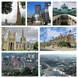
Sheffield is a city in South Yorkshire, England, whose name derives from the River Sheaf which runs through it. The city serves as the administrative centre of the City of Sheffield. It is historically part of the West Riding of Yorkshire and some of its southern suburbs were transferred from Derbyshire to the city council. It is the largest settlement in South Yorkshire.

The University of Sheffield is a public research university in Sheffield, South Yorkshire, England. Its history traces back to the foundation of Sheffield Medical School in 1828, Firth College in 1879 and Sheffield Technical School in 1884. University College of Sheffield was subsequently formed by the amalgamation of the three institutions in 1897 and was granted a royal charter as University of Sheffield in 1905 by King Edward VII.

Stocksbridge is a town and civil parish, in the City of Sheffield, in South Yorkshire, England. Historically part of the West Riding of Yorkshire, it lies just to the east of the Peak District. The town is located in the steep-sided valley of the Little Don River, below the Underbank Reservoir. It blends into the areas of Deepcar, Bolsterstone and the eastern end of Ewden valley around Ewden village, which are also within the civil parish. The population of the civil parish as of the 2011 census was 13,455.

Broomhill and Sharrow Vale — which includes the districts of Broomhill, Broomhall, Crookesmoor, Endcliffe, Sharrow Vale and Tapton Hill — is one of the 28 electoral wards in City of Sheffield, England. The ward was created following the 2015 local government boundary review out of parts of the old Broomhill, Central and Nether Edge wards. It is located in the western part of the city. The population of the Broomhill ward in 2011 was 16,966 people in 5,708 households, covering an area of 2.7 km2. Broomhill & Sharrow Vale is one of the wards that make up the Sheffield Central Parliamentary Constituency.

Thorncliffe Park is a neighbourhood in Toronto, Ontario, Canada, in the former Borough of East York.

Chapeltown is a suburb of north-east Leeds, in West Yorkshire, England. It is part of the Leeds City Council Ward of Chapel Allerton. It is approximately one mile north of Leeds city centre.

Doncaster Sheffield Airport, formerly named and commonly referred to as Robin Hood Airport, was an international airport in Finningley near Doncaster in South Yorkshire, England, in operation between 2005 and 2022. The site lies 6 mi (10 km) south-east of the centre of Doncaster and 19 mi (31 km) east of Sheffield.
Ecclesfield is a village and civil parish in the City of Sheffield, South Yorkshire, England, about 4 miles (6 km) north of Sheffield City Centre. Ecclesfield civil parish had a population of 32,073 at the 2011 Census. Ecclesfield wards of the City of Sheffield had a population of 35,994 in 2011. The population of Ecclesfield village stood at 7,163 in the most recent census.

East Ecclesfield ward—which includes the districts of Chapeltown and Ecclesfield—is one of the 28 electoral wards in City of Sheffield, England. It is located in the northern part of the city and covers an area of 3.8 square miles (9.8 km2) in the eastern part of Ecclesfield Parish. The population of this ward in 2011 was 18,295 people in 7,863. East Ecclesfield is one of the six wards that make up the Sheffield Hillsborough Parliamentary constituency. The Boundary Commission for England, in their final report, recommended that East Ecclesfield should become part of a reformed Penistone and Stocksbridge constituency. The East Ecclesfield ward is composed of eight polling districts. These include Blackburn, Chapeltown, Ecclesfield, Ecclesfield Common, High Greave, Horbury, Warren and Wheata.

Chapeltown is a suburb of Sheffield in South Yorkshire, England. It is part of the Parish of Ecclesfield. It is historically within the West Riding of Yorkshire.

Chapeltown railway station, originally known as Chapeltown South, is a railway station serves the Sheffield suburb of Chapeltown in South Yorkshire, England. The station is 7.25 miles (12 km) north of Sheffield on the Hallam and Penistone Lines.

The Blackburn Brook is a stream in Sheffield, South Yorkshire, England which flows through the Blackburn Valley along the M1 and Ecclesfield Road and joins the River Don near the Meadowhall shopping centre. Downstream from the A61 road at Chapeltown the Blackburn Brook is defined as a main river by the Environment Agency, which requires new building development to be at least 26 feet (8 m) from the bank side as a flood defence measure and to allow access to the watercourse for maintenance.

High Green is a
suburb of Sheffield, England, located about 8 miles from the city centre. It is found to the north of Chapeltown and is served by buses; the nearest rail station is in Chapeltown 1 mile away. The suburb falls within the West Ecclesfield ward of the city Council.

Chapeltown Central railway station was situated on the former South Yorkshire Railway's Blackburn Valley line between Ecclesfield East and Westwood. The station which was also known as Chapeltown and Thorncliffe was intended to serve Chapeltown, South Yorkshire, England, although about 1 mile (1.6 km) from its centre. It also served the works of Newton, Chambers & Company, one of the largest industrial companies in the area.

Westwood railway station was situated on the South Yorkshire Railway's Blackburn Valley line between Chapeltown Central and Birdwell & Hoyland Common. The station served an area of few houses apart from two rows of miners' cottages known as "Westwood Row". The nearest settlement was at High Green, just over 1.5 miles (2.4 km) away. Tankersley colliery was north of the station and was connected to the railway line by an industrial spur. Another spur left the line in Westwood station and led via a switchback to Thorncliffe Iron Works and Thorncliffe Colliery.

Newton, Chambers & Co. was one of England's largest industrial companies. It was founded in 1789 by George Newton and Thomas Chambers.

Potternewton also Potter Newton is a suburb and parish between Chapeltown and Chapel Allerton in north-east Leeds, West Yorkshire, England. It is in the Chapel Allerton ward of Leeds City Council.
Ecclesfield School is a coeducational secondary school with academy status situated on Chapeltown Road (A6135) between Chapeltown and Ecclesfield, South Yorkshire in the East Ecclesfield district of Sheffield, England. It is for ages 11–16. It has about 1,750 pupils, making it the largest school in Sheffield.

Furness Academy is a secondary school in Barrow-in-Furness, England. It is the fourth academy to have been formed in the county of Cumbria after the closure of Alfred Barrow School, Parkview Community College of Technology and Thorncliffe School in 2009. Having utilised numerous buildings of the former Parkview and Thorncliffe Schools since 2009, a single £22 million building opened in the Parkside area of the town in September 2013.

Chapeltown is a village on Valentia Island in the south-west of County Kerry. It is the second major settlement on the Island, the other being Knightstown 4 kilometers away. Chapeltown is located in the centre of the Island, approximately 3 kilometers from the bridge which links the island to the mainland at Portmagee.


