
High Bradfield is a rural village 6.5 miles (10 km) north-west of the centre of Sheffield in South Yorkshire, England and within the city's boundaries. The village lies just within the Peak District National Park, 1.3 miles (2 km) inside the park's north-eastern border, is at an altitude of 260 metres (850 feet) AOD, and has extensive views across Bradfield Dale towards Derwent Edge and the Dark Peak.
Wadsley Bridge is a suburb of Sheffield, South Yorkshire, England, 3 miles (4.8 km) northwest of the city centre. The area is a mixture of residential housing and small industrial and commercial premises. The suburb falls within the Hillsborough ward of the City.
Wadsley is a suburb of the City of Sheffield in South Yorkshire, England. It stands 3 miles (5 km) north-west of the city centre at an approximate grid reference of SK321905. At the 2011 Census the suburb fell within the Hillsborough ward of the City. Wadsley was formerly a rural village which was engulfed by the expansion of Sheffield in the early part of the 20th century.
Owlerton is a suburb of the city of Sheffield, England, 2.2 miles (3.5 km) northwest of the city centre near the confluence of the River Don and River Loxley. Owlerton was a small rural village from the Early Middle Ages; it became part of Sheffield in the early 1900s as the city expanded. Owlerton is just east of Hillsborough and within the Hillsborough ward. Hillsborough Stadium, Hillsborough Leisure Centre and Hillsborough College are in Owlerton.

Hillsborough Park is a large parkland area in Hillsborough, Sheffield, South Yorkshire, England. It is situated three miles north-west of the city centre. It owned by Sheffield City Council and is one of the 13 designated "City Parks".
Middlewood is a north western suburb of Sheffield, South Yorkshire, England. The suburb falls within the Stannington ward of the City.
Formal education in Sheffield, England, takes place at the city's two universities, 141 primary schools and 28 secondary schools.
Hillsborough is a suburb in north-west Sheffield, South Yorkshire, England. The centre of the district is popularly thought to be 'Hillsborough Corner' where Langsett Road, Middlewood Road, Holme Lane and Bradfield Road all meet. The Hillsborough ward population at the 2011 Census was 18,605.
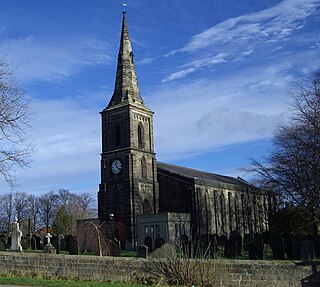
Wadsley Parish Church is situated within the city of Sheffield, South Yorkshire, England. It is located on Worrall Road, 3 miles (5 km) north west of the city centre in the suburb of Wadsley, which was formerly a village outside the city boundary. The church is quite unusual in that it is not dedicated to a saint. It is a grade II listed building.

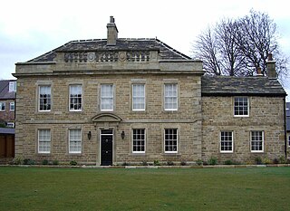
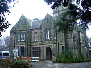
Hillsborough House, later called Hillsborough Hall, is a large, stone-built mansion constructed in the Adam style in the latter part of the 18th century. It stands 2+1⁄2 miles north-west of the centre of Sheffield at grid reference SK331901 in the suburb of Hillsborough within Hillsborough Park, a council-owned public recreational area. For 124 years the house was a private dwelling, but since 1906 it has housed the Hillsborough branch library. It is a Grade II listed building as are the coach house and stables which stand 22 yards (20 m) north-west of the main house.
Burrowlee House is a Georgian style building situated at grid reference SK334901 on Broughton Road in the Owlerton district of Sheffield, some 2.5 miles (4 km) north-west of the city centre. It is the oldest building in the Owlerton and Hillsborough area and was one of the first houses constructed wholly from brick in Sheffield. The house is a grade two listed building with two storeys and five bays with a stone balustrade over the three middle bays, there is a date stone over the main door.
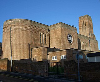
Sacred Heart Church is located in Forbes Road in the Hillsborough district of the city of Sheffield, South Yorkshire, England at grid reference SK333894. It is a Roman Catholic church in the Diocese of Hallam and is a Grade II listed building. The church is situated in an elevated position and its tower is a prominent landmark in the area.
Ecclesfield School is a coeducational secondary school with academy status situated on Chapeltown Road (A6135) between Chapeltown and Ecclesfield, South Yorkshire in the East Ecclesfield district of Sheffield, England. It is for ages 11–16. It has about 1,750 pupils, making it the largest school in Sheffield.

Fair House Farmhouse is a 17th-century building situated on Annet Lane in the village of Low Bradfield within the boundary of the City of Sheffield in South Yorkshire, England. The farmhouse is a Grade II* Listed Building while the stable and garage buildings immediately to the west of the main house are Grade II listed.

Underbank Chapel is a Unitarian place of worship in Stannington, a suburb of Sheffield, South Yorkshire. It is a member of the General Assembly of Unitarian and Free Christian Churches, the umbrella organisation for British Unitarians.

35 Well Meadow Street is the site of a house, attached workshops, courtyard complex and a crucible furnace. It is located in the St Vincent's Quarter of the City of Sheffield in England, it is also part of the Well Meadow Conservation Area. The buildings and furnace are grade II* listed buildings because of their importance as part of Sheffield’s industrial heritage and it is regarded as, “One of the most significant of the city’s 19th century industrial monuments”. It has now been converted into residences.
Gleadless Valley is a housing estate and electoral ward of the City of Sheffield in England. The population of the estate at the 2021 Census was 9,724. It lies 2.5 miles (4.0 km) south-southeast of the city centre. Formerly a rural area, Gleadless Valley was developed as a large housing project with around 4000 dwellings by Sheffield City Council between 1955 and 1962. It is an area of undulating land drained by the Meers Brook, which has its source on the high ground in the woodland at Gleadless. Adjacent are Gleadless to the east, Norton to the south-west, Heeley to the west and Arbourthorne to the north.

Banner Cross Methodist Church is situated in the district of Banner Cross in the city of Sheffield, England. The church stands on Ecclesall Road South, 2.5 miles (4 km) south-west of the city centre. The church and attached schoolroom as well as the boundary wall and gate piers are all Grade II listed buildings.
Mylnhurst is a small English country house on Button Hill in the Ecclesall area of Sheffield, England. The house was previously a private residence, it now serves as a private school. The house along with the attached stables and lodge are Grade II listed buildings.

Loxley United Reformed Church is a derelict Grade II* listed building located on Loxley Road in Loxley, a western suburb of the City of Sheffield, England. It is currently in a fire damaged state.

