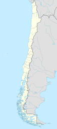
The Atacama Region is one of Chile's 16 first order administrative divisions. It comprises three provinces: Chañaral, Copiapó and Huasco. It is bordered to the north by Antofagasta, to the south by Coquimbo, to the east by the provinces of Catamarca, La Rioja and San Juan of Argentina, and to the west by the Pacific Ocean. The regional capital Copiapó is located 806 km (501 mi) north of the country's capital of Santiago. The region occupies the southern portion of the Atacama Desert, the rest of the desert is mainly distributed among the other regions of Norte Grande.

Proustite is a sulfosalt mineral consisting of silver sulfarsenide, Ag3AsS3, known also as ruby blende, light red silver, arsenic-silver blende or ruby silver ore, and an important source of the metal. It is closely allied to the corresponding sulfantimonide, pyrargyrite, from which it was distinguished by the chemical analyses of Joseph L. Proust (1754–1826) in 1804, after whom the mineral received its name.

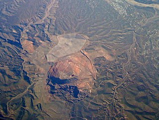
Chuquicamata is the largest open pit copper mine in terms of excavated volume in the world. It is located in the north of Chile, just outside Calama, at 2,850 m (9,350 ft) above sea level. It is 215 km (134 mi) northeast of Antofagasta and 1,240 km (770 mi) north of the capital, Santiago. Flotation and smelting facilities were installed in 1952, and expansion of the refining facilities in 1968 made 500,000 tons annual copper production possible in the late 1970s. Previously part of Anaconda Copper, the mine is now owned and operated by Codelco, a Chilean state enterprise, since the Chilean nationalization of copper in the late 1960s and early 1970s. Its depth of 850 metres (2,790 ft) makes it the second deepest open-pit mine in the world, after Bingham Canyon Mine in Utah, United States.

Acanthite is a form of silver sulfide with the chemical formula Ag2S. It crystallizes in the monoclinic system and is the stable form of silver sulfide below 173 °C (343 °F). Argentite is the stable form above that temperature. As argentite cools below that temperature its cubic form is distorted to the monoclinic form of acanthite. Below 173 °C acanthite forms directly. Acanthite is the only stable form in normal air temperature.

Adamite is a zinc arsenate hydroxide mineral, Zn2AsO4OH. It is a mineral that typically occurs in the oxidized or weathered zone above zinc ore occurrences. Pure adamite is colorless, but usually it possess yellow color due to Fe compounds admixture. Tints of green also occur and are connected with copper substitutions in the mineral structure. Olivenite is a copper arsenate that is isostructural with adamite and there is considerable substitution between zinc and copper resulting in an intermediate called cuproadamite. Zincolivenite is a recently discovered mineral being an intermediate mineral with formula CuZn(AsO4)(OH). Manganese, cobalt, and nickel also substitute in the structure. An analogous zinc phosphate, tarbuttite, is known.

Copiapó is a city and commune in northern Chile, located about 65 kilometers east of the coastal town of Caldera. Founded on December 8, 1744, it is the capital of Copiapó Province and Atacama Region.

Porphyry copper deposits are copper ore bodies that are formed from hydrothermal fluids that originate from a voluminous magma chamber several kilometers below the deposit itself. Predating or associated with those fluids are vertical dikes of porphyritic intrusive rocks from which this deposit type derives its name. In later stages, circulating meteoric fluids may interact with the magmatic fluids. Successive envelopes of hydrothermal alteration typically enclose a core of disseminated ore minerals in often stockwork-forming hairline fractures and veins. Because of their large volume, porphyry orebodies can be economic from copper concentrations as low as 0.15% copper and can have economic amounts of by-products such as molybdenum, silver, and gold. In some mines, those metals are the main product.
A silver rush is the silver-mining equivalent of a gold rush, where the discovery of silver-bearing ore sparks a mass migration of individuals seeking wealth in the new mining region.
In ore deposit geology, supergene processes or enrichment are those that occur relatively near the surface as opposed to deep hypogene processes. Supergene processes include the predominance of meteoric water circulation (i.e. water derived from precipitation) with concomitant oxidation and chemical weathering. The descending meteoric waters oxidize the primary (hypogene) sulfide ore minerals and redistribute the metallic ore elements. Supergene enrichment occurs at the base of the oxidized portion of an ore deposit. Metals that have been leached from the oxidized ore are carried downward by percolating groundwater, and react with hypogene sulfides at the supergene-hypogene boundary. The reaction produces secondary sulfides with metal contents higher than those of the primary ore. This is particularly noted in copper ore deposits where the copper sulfide minerals chalcocite (Cu2S), covellite (CuS), digenite (Cu18S10), and djurleite (Cu31S16) are deposited by the descending surface waters.

The Alicanto is a nocturnal mythological bird of the desert of Atacama, pertaining to Chilean mythology. Legend says that the alicanto's wings shine at night with beautiful metallic colors, and their eyes emit strange lights. The color of the wings may indicate the type of ore it eats, golden if from a gold mine and silvery if from a silver mine. Some descriptions also portray the color of the wings as copper-green.
The San Manuel Copper Mine was a surface and underground porphyry copper mine located in San Manuel, Pinal County, Arizona. Frank Schultz was the original discoverer, in 1879, but the main body of the deposits were discovered by Henry W. Nichols in 1942. The exploration drilling went on from 1943 to 1948, with the first mine shaft built 1948. Louis Lesser developed a mining city to service Nichols’ newly discovered deposits, and the development was completed about 1954. The first major production began in 1955. The mine and smelter were permanently closed in 2003.

Atacama Province was one of the administrative divisions of Chile from 1843 to 1976. The capital was Copiapó.

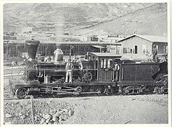
Between 1830 and 1850, Chilean silver mining grew at an unprecedented pace which transformed mining into one of the country's principal sources of wealth. The rush caused rapid demographic, infrastructural, and economic expansion in the semi-arid Norte Chico mountains where the silver deposits lay. A number of Chileans made large fortunes in the rush and made investments in other areas of the economy of Chile. By the 1850s, the rush was in decline and lucrative silver mining definitively ended in the 1870s. At the same time, mining activity in Chile reoriented to saltpetre operations.

Juan Godoy was a Chilean farmer and miner who in 1832 discovered an outcrop (reventón) of silver 50 km (31 mi) south of Copiapó in Chañarcillo, sparking the Chilean silver rush.

Escondida is a copper mine at 3,100 metres (10,200 ft) elevation in the Atacama Desert in Antofagasta Region, Chile.

Potrerillos is a ghost town in the interior of Atacama Region, Chile. Potrerillos became established as mining camp in the 1920s by Andes Copper Mining Company.
During most of Chile's history, from 1500 to the present, mining has been an important economic activity. 16th century mining was oriented towards the exploitation of gold placer deposits using encomienda labour. After a period of decline in the 17th century, mining resurged in the 18th and early 19th century, this time concentrating chiefly on silver. In the 1870s silver mining declined sharply. Chile took over the highly lucrative saltpetre mining districts of Peru and Bolivia in the War of the Pacific (1879–83). In the first half of the 20th century copper mining overshadowed the declining saltpetre mining.
Miguel Gallo Vergara was a Chilean millionaire mining entrepreneur, politician and patriot. He was mayor of Copiapó for the year 1820, and was appointed a Deputy of the Republic of Chile representing Copiapó, Chañaral and Freirina from 1849 to 1852. A pioneer of the silver mining industry in Chile, working with Juan Godoy from 1832, he is still remembered as an illustrious figure in the Atacama mining industry and in the history of Copiapó.
Tres Puntas is silver deposit and mine in Chile's Atacama Region. It is located 80 km north of the regional capital Copiapó. Tres Puntas was discovered in 1848 sparking the largest silver rush in Chile since Chañarcillo was discovered in 1832. The deposit was discovered by Miguel Osorio but came to be owned by Apolinario Soto.
Agua Amarga is a silver deposit and defunct mining district in Chile's Atacama Region. It is located 30 km south of Vallenar. Agua Amarga was discovered in 1811 and its silver was instrumental to finance the Chilean War of Independence. An enquiry by Ignacy Domeyko tells of 150 individual mines active in Agua Amarga in 1822. Calera, Colorada and Aris are mentioned as the most productive mines of Agua Amarga.