Chempanoda

Last updated

Chempanoda
Village
Peruvannamuzhi (1).jpg
Road to Cheampanoda
CountryFlag of India.svg  India
State Kerala
District Kozhikode
Languages
  Official Malayalam, English
Time zone UTC+5:30 (IST)
PIN
673528
Telephone code0496
Vehicle registration KL-18,KL-11,KL-77
Coastline0 kilometres (0 mi)
Nearest cityKozhikode
Sex ratio 1028 /
Literacy98.6%
Lok Sabha constituencyVatakara
Climate Tropical monsoon (Köppen)
Avg. summer temperature35 °C (95 °F)
Avg. winter temperature20 °C (68 °F)
Chempanoda

Chempanoda/Chempanod is a village located in the northeastern part of the Kozhikode district of Kerala, India. [1] [2] It is situated near the popular tourist destination of Peruvannamuzhi.

Contents

Chempanoda is a tourist spot.[ citation needed ] The village is surrounded by two rivers and is bordered by mountains to the east, which are part of the Western Ghats mountain range. The local economy primarily revolves around agriculture, with residents engaging in farming activities and cultivating crops such as rubber trees, coconut trees, areca nut trees.

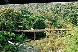
The road that passes through the village leads to another nearby village called Poozhithode, which is situated in a hilly area with reserved forests.

Tourist spots

Peruvannamoozhi Dam and Surrounding areas Peruvannamuzhi.jpg
Peruvannamoozhi Dam and Surrounding areas
Peruvannamoozhi Dam Kuttiady dam1.JPG
Peruvannamoozhi Dam
Pottiyapara Pottiapara1.jpg
Pottiyapara

Peruvannamoozhy village is situated 60 km from Kozhikode city in Kerala. It has been recognized as an eco-tourism destination in Kerala, with the Tourism Minister inaugurating the eco-tourism project on 10 August 2008.[ citation needed ]

Located in the Western Ghats, Peruvannamoozhy is an ecological hotspot[ citation needed ] known for its rich biodiversity. It is home to more than 680 species of rare plants. The destination offers various facilities and attractions, including a wild animal rehabilitation center, bird sanctuary, crocodile farm, snake park, spice garden, trekking trails, and boating opportunities. The reservoir in the area provides options for speedboat and rowboat cruises. Additionally, there is a garden named Smaraka Thottam, which is dedicated to the memory of freedom fighters from the region.[ citation needed ]

In additional to the natural environment, the irrigation dam and the garden nearby are added attractions. As part of eco tourism initiatives, the following facilities have been created:

The Peruvannamuzhi Dam is located 60 km from the Kozhikode city. You could reach here by private bus or by taxi.

Janakikadu is a thick forest which attracts thousands of tourists every year.[ citation needed ] There is a wide variety of birds in this forest. An ecological hotspot in the Western Ghats, the eco tourism destination of Janakikadu is home to over 680 species of rare plants.[ citation needed ]

This region offers immense scope for picnicking and Trekking programmes. The there is a scenic view of the valley from the top of Pottiyapara.

Climate

Chempanoda has a generally humid tropical climate with a very hot season extending from March to May. The average annual rainfall is more than 3500 mm.this is one of the highest rain fall region in Calicut district.

Demographics

Christians constitute majority of the population, followed by Muslim and Hindu communities respectively. The majority of the inhabitants are successors of the Syrian Christians of Central Kerala who migrated to Northern Kerala by the Malabar Migration.

Nearest towns

Nearest villages

Transportation

Chempanoda village connects to other parts of India through Vatakara town on the west and Kuttiady town on the east. National highway No.66 passes through Vatakara and the northern stretch connects to Goa and Mumbai. The southern stretch connects to Cochin and Trivandrum. The eastern National Highway No.54 going through Kuttiady connects to Mananthavady, Mysore and Bangalore. The nearest airports are at Kannur and Kozhikode. The nearest railway station is at Vatakara. Proposed WAYANAD hairpin less road is passing through chempanoda.

Related Research Articles

<span class="mw-page-title-main">Brahmagiri (Karnataka)</span> Mountain range in India

Brahmagiri, is a mountain range in the Western Ghats of south India. It is situated on the border between Kodagu district in Karnataka state in the north and Wayanad district of Kerala state on the south. Brahmagiri Hill, at 1608 m height, is a scenic tourist attraction. The top of Brahmagiri Hill is well forested and has much wildlife.

<span class="mw-page-title-main">Vatakara</span> Place in Kerala, India

Vatakara, also spelled Vadakara, IPA: [ʋɐɖɐgɐɾɐ], French: Bargaret, is a Municipality in the state of Kerala, India. Vatakara is located between Kannur and Kozhikode. The municipality of Vatakara covers an area of 23.33 km2 (9.01 sq mi) and is bordered by Mahé to the north and Payyoli to the south. It is the headquarters of Vatakara taluk, which consists of 22 panchayats. During the reign of the Kolathiris and Zamorins, Vatakara was known as Kadathanadu. During the British Raj, it was part of the North Malabar region of Malabar District in the state of Madras. The historic Lokanarkavu temple, made famous by the Vadakkan Pattukal, is situated in Vatakara. A new tardigrade species collected from Vadakara coast has been named after Kerala State; Stygarctus keralensis.

Memunda is a small village near Vatakara town in Kozhikode district of Kerala, south India.

Muthappan Kavu, also known as Muthappan Mala is a village situated in Memunda, 5 km from Vatakara town in Kozhikode district of Kerala state, India.

<span class="mw-page-title-main">Koorachundu</span> Village in Kerala, India

Koorachundu is a village towards the north east of Kozhikode district of Kerala in India.

Chakkittapara is a panchayat as well as a town in the Kozhikode district of Kerala state, India. Chakkittapara borders Wayanad district to the east. Administratively, Chakkittapara comes under the Perambra block panchayat and Koyilandy Taluk, containing 15 wards and destinations like Kulathuvayal, Peruvannamuzhi, Chempanoda, Poozhithode, Muthukadu, Koovapoyil, Narinada, Chempra, and Pannikkottoor.

<span class="mw-page-title-main">Iringal</span> Village in Kerala, India

Iringal is a village in Kozhikode district in the state of Kerala, India.

Maruthonkara is a village and grama panchayat in Kozhikode district in the state of Kerala, India. The nearest town situated near by here is Kuttiyadi. Peruvannamuzhi, Thottilpalam, Chempanoda, kunduthode, chengaroth and Passukkadavu are near by places from here.

<span class="mw-page-title-main">Ambalavayal</span> Town in Kerala, India

Ambalavayal is a village in Wayanad district in the state of Kerala, India. The Wayanad Heritage Museum is located in the village.

<span class="mw-page-title-main">Padinharethara</span> Village in Kerala, India

Padinharathara is a village and important junction in Wayanad district in the state of Kerala, India. The biggest earth dam in Asia is situated in this Village.

<span class="mw-page-title-main">Thirunelly</span> Village in Kerala, India

Thirunelly is a village in Wayanad district in the state of Kerala, India.

<span class="mw-page-title-main">Vilangad</span> Village in Kerala, India

Vilangad is a village in Kozhikode district in the state of Kerala, India. Vilangad is a small town, north-east of Kozhikode district bordering with Wayanad and Kannur. It is situated 32 km. away from sub-district headquarter Vatakara and 71 km. away from district headquarter Kozhikode.

<span class="mw-page-title-main">Peruvannamuzhi</span> Village in Kerala, India

Peruvannamuzhi or Peruvannamoozhy is a village in Chakkittapara Panchayath Kozhikode district, Kerala, India. Peruvannamuzhi forms part of the newly inaugurated Malabar Wildlife Sanctuary and is rich in flora and fauna.

<span class="mw-page-title-main">Poozhithode</span> Gramam in Kerala, India

Poozhithode is a village located at the easternmost end of Calicut, Kerala, India. It is a hill country and is about 65 km from Calicut located in Chakittapara panchayath. Poozhithode has on its one side Kadunthara puzha and on the other side Wyanad forest.

Kuttiady is one of the Major towns situated in the north-eastern part of Kozhikode district of Kerala, India. It is located 24 km (15 mi) from Vadakara and 50 km (31 mi) from Kozhikode. Kuttiady is situated in the slopes of the Western Ghats.

Koolivayal is a small town situated near Panamaram in Wayanad, Kerala, India. Its economy is based on agriculture.

<span class="mw-page-title-main">Perumpadikkunnu</span>

Perumpadikkunnu is a place situated in Wayanad Ambalavayal, Kerala, India. It is 12 km from Ambalavayal. Karappuzha lake's a part is on perumpadikkunnu. The ward member in Perumpadikkunnu is now Suresh Kumar. There is a school named St. Mary's LP School Munnoor. A famous club was situated in Perumpadikkunnu named 'Yuvarasmi'.

<span class="mw-page-title-main">Transportation in Wayanad</span>

The district capital of Wayanad is Kalpetta town. Kalpetta has very good road connectivity with the rest of Kerala and neighboring South Indian cities. National Highway 766 (India) NH766 connects Kalpetta with Kozhikode and Mysore. State Highways connect Kalpetta with Ooty in Tamil Nadu and Madikeri in Karnataka.

<span class="mw-page-title-main">Neervaram</span> Place in Kerala, India

Neervaram is a village near Panamaram in Wayanad district of Kerala state, India.

References

  1. "Chempanoda, Chakkittapara Panchayat, Kozhikode District, Kerala, India". Kerala Tourism. Retrieved 1 April 2022.
  2. "Chempanoda Village | Map of Chempanoda Village in Quilandy Tehsil, Kozhikode of Kerala". www.mapsofindia.com. Retrieved 1 April 2022.