Related Research Articles

Thrissur, formerly Trichur, also known by its historical name Thrissivaperur, is a city and the headquarters of the Thrissur district in Kerala, India. It is the third largest urban agglomeration in Kerala after Kochi and Kozhikode, and the 21st largest in India. The city is built around a 65-acre (26 ha) hillock called Thekkinkadu Maidanam which seats the Vadakkunnathan temple. It is located 304 kilometres (189 mi) north-west of the state's capital city, Thiruvananthapuram. Thrissur was once the capital of the Kingdom of Cochin, and was a point of contact for the Assyrians, Greeks, Persians, Arabs, Romans, Portuguese, Dutch and English.

Ollukara is a residential area in the City of Thrissur in Kerala state of India. Ollukkara is the Ward 15 of Thrissur Municipal Corporation. It is located close to Mannuthy. It is the first village in Kerala to attain legal literacy.

Sakthan Thampuran Nagar is one of the business districts of Thrissur city in Kerala state, South India. It was named after King of the Cochin, Sakthan Thampuran, the very architect of Thrissur.
Kuttippuram is a town and a block headquarters, which is situated in the Tirur Taluk, Malappuram district in the Indian state of Kerala. The town is located 32 kilometres south of Malappuram. The Bharathappuzha river flows through Kuttippuram. According to the last Census of India conducted in 2011,
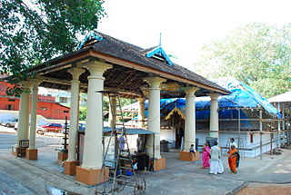
Kuttankulangara Sri Krishna Temple located in Punkunnam, Thrissur district of Kerala, south India and is considered to be over a 300 years old. It is located in the Kuttankulangara ward of Thrissur Municipal Corporation. This temple is a classic example of the Kerala style of architecture. It is 500 m away from Punkunnam Railway station. It is believed that the god gives the fortune of progeny(സന്താനം). There is an interesting ritual called Pannivetta(പന്നി വ

Thrissur Lok Sabha constituency is one of the 20 Lok Sabha (parliamentary) constituencies in the state of Kerala in southern India.

Archaeological Museum, Thrissur is an art and archaeological museum situated in Thrissur City of Kerala state, India. The museum is located in the Thrissur Zoo compound.

Marth Mariam Cathedral is the cathedral of the Chaldean Syrian Church of India, part of the Assyrian Church of the East. It is located in Thrissur City in the state of Kerala, It is the city's first Christian church inside the fort gates and is the fourth church in the Thrissur Municipal Corporation
Aswini Hospital is a private hospital situated in Thrissur, in the Kerala state of India. It is situated near Vadakkechira Bus stand and Poonkunam railway station in Thrissur Corporation. Established as a 40-bed hospital in 1987, it is now a 300-bed Multi-Super Speciality General Hospital. The hospital also runs the Aswini School of Nursing in Nadathara, Thrissur. The hospital offers treatment to the people of Thrissur, Palakkad and Malappuram districts.
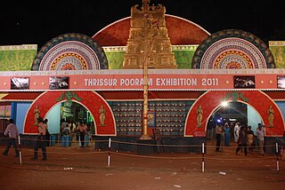
All India Agricultural, Industrial, Educational and Cultural Exhibition or commonly called the Thrissur Pooram Exhibition is an exhibition organised jointly by Paramekkavu Bagavathi Temple Devaswom and Thiruvambadi Sri Krishna Temple Devaswom, ahead of Thrissur Pooram in Thekkinkadu Maidan in Thrissur city. It is usually conducted over a period of 40 to 50 days during the Thrissur Pooram.The exhibition is the largest in Kerala in terms of attendance and floor space.

Ollur State assembly constituency is one of the 140 state legislative assembly constituencies in Kerala. It is also one of the 7 state legislative assembly constituencies included in the Thrissur Lok Sabha constituency. As of the 2021 assembly elections, the current MLA is K. Rajan of CPI.
The Thrissur Municipal Corporation is the civic body that governs Thrissur city in Kerala, India. It is the third largest city Corporation in the state of Kerala by area and fourth largest in population. Established as a Municipality since 1921 under the Cochin Municipal Regulations, it is responsible for civic infrastructure and administration; the distribution of electricity and water for Thrissur city. The Corporation manages 101.42 km of Thrissur city limits of through 55 wards through five zones Ayyanthole, Vilvattom, Ollukkara, Ollur and Koorkanchery. Thrissur Municipal Corporation has been formed with functions to improve the infrastructure of town.

The city of Thrissur is situated in the southwest of the South Indian state of Kerala of Thrissur district. A landlocked city, Thrissur is located on a hillock which is surrounded by Thrissur Kole Wetlands. Thrissur district borders with Palakkad district in east, Malappuram district in the north, Ernakulam district in the South and Arabian Sea in the west.
Peringavu is a residential area situated in the City of Thrissur in Kerala state of India. Peringavu is Ward 5 of Thrissur Municipal Corporation.
Kalathodu is a residential area situated in the City of Thrissur in Kerala state of India. Kalathodu is Ward 20 of Thrissur Municipal Corporation.
Chelakkottukara is a residential area situated in the City of Thrissur in Kerala state of India. Chelakkottukara is Ward 21 of Thrissur Municipal Corporation. Important locations: Jubilee Mission Medical college, Thope Stadium, Mar Aprem Church, St. Thomas H.S.S Thope, Seventh Day Adventist Senior Secondary School, Mar Thimotheus High School.
Elthuruth is a residential area situated in the city of Thrissur in Kerala state of India. Elthuruth is Ward 45 of Thrissur Municipal Corporation. This is one of the most scenic suburbs of Thrissur corporation. The place is surrounded by paddy fields and canals forming a branch of kole wetlands. St. Aloysius School and College are the educational institutions serving this area.
Civil Station is a residential area situated in the City of Thrissur in Kerala state of India. Civil Station is Ward 54 of Thrissur Municipal Corporation.
Administration of Thrissur, Kerala, India, is handled by the Thrissur Municipal Corporation, consisting of 55 councilors and headed by the city's mayor.

Thrissur District has four types of administrative hierarchies:
References
- ↑ "Municipal Council". Corporation of Thrissur. Archived from the original on 24 December 2012. Retrieved 31 July 2012.
- ↑ "All Information on Kerala". THRISSUR CORPORATION. Archived from the original on 18 August 2013. Retrieved 31 July 2012.