Kozhikode, also known in English as Calicut, is an Indian city and the second-largest metropolitan city in the State of Kerala. It is also the 19th largest in the country with a population of two million according to the 2011 census. Kozhikode is classified as a Tier 2 city by the Government of India.

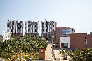
Kochi, formerly known in English as Cochin is a major port city on the Malabar Coast of India bordering the Laccadive Sea, which is a part of the Arabian Sea. It is part of the district of Ernakulam in the state of Kerala and is often referred to as Ernakulam. Kochi is the most densely populated city in Kerala. As of 2011, it has a corporation limit population of 677,381 within an area of 94.88 km2 and a total urban population of more than of 2.1 million within an area of 440 km2, making it the largest and the most populous metropolitan area in Kerala. Kochi city is also part of the Greater Cochin region and is classified as a Tier-II city by the Government of India. The civic body that governs the city is the Kochi Municipal Corporation, which was constituted in the year 1967, and the statutory bodies that oversee its development are the Greater Cochin Development Authority (GCDA) and the Goshree Islands Development Authority (GIDA).

Thrissur, formerly Trichur, also known by its historical name Thrisshivaperur, is a city and the headquarters of the Thrissur district in Kerala, India. It is the third largest urban agglomeration in Kerala after Kochi and Kozhikode, and the 21st largest in India. It is famous for the Thrissur Pooram festival. The city is built around a 65-acre (26 ha) hillock called the Thekkinkaadu Maidaanam which seats the Vadakkumnathan temple. It is located 304 kilometres (189 mi) north-west of the state's capital city, Trivandrum. Thrissur was once the capital of the Kingdom of Cochin. Thrissur is known as "Cultural Capital of Kerala" due of its cultural, spiritual and religious leanings throughout history. One of its main cultural events is the Thrissur Pooram, which attracts quite a number of tourists and travellers.

Ernakulam, IPA: [erɐɳɐːguɭɐm]; IAST: Eṟaṇākuḷaṁ, in Malayalam: എറണാകുളം) is a district of Kerala, India, that takes its name from the eponymous city division in Kochi. It is situated in the central part of the state, spans an area of about 3,000 square kilometres (1,200 sq mi), and is home to over 9% of Kerala's population. Its headquarters are located at Kakkanad. The district includes Kochi, also known as the commercial capital of Kerala, which is famous for its ancient Hindu temples, churches, synagogues and mosques. The district includes the largest metropolitan region of the state: Greater Cochin. Ernakulam is the district that yields the most revenue and the largest number of industries in the state. Ernakulam is the third most populous district in Kerala, after Malappuram and Thiruvananthapuram. The district also hosts the highest number of international and domestic tourists in Kerala state.
Ayyanthole is an administrative and residential area situated in the City of Thrissur, Kerala, India. Ayyanthole is the 52nd Ward of Thrissur Municipal Corporation. Ayyanthole is the administrative center for the Thrissur District. Ayyanthole houses the various state governmental offices, as well as the District and Sessions Courts.

Angamaly (Aṅkamāli), IPA: [ɐŋgɐmɐːli], is a municipality and the northernmost tip of the city of Kochi in Kerala, India. Situated about 30 km (19 mi) north of the city centre, the area is the northern gateway to the commercial capital of Kerala and is an integral part of the Kochi metropolitan area. The town lies at the intersection of Main Central Road and National Highway 544. MC Road, which starts from Thiruvananthapuram ends at Angamaly at its intersection with NH 544. Also Known as the Airport City as Cochin International Airport is Less than 10KM away from the City
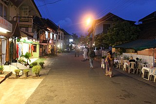
Fort Kochi, Fort Cochin in English, Cochim de Baixo in Cochin Portuguese creole, is a locality in the Cochin district of Kerala, India. The locality is 16 km away from Cochin city and takes its name from Fort Manuel of Cochin, the first European fort of the Portuguese East Indies on Indian soil. This is part of a handful of water-bound islands and islets toward the south-west of the mainland Kochi, and collectively known as Old Cochin or West Kochi. Adjacent to this is Mattancherry. In 1967, these three municipalities, along with a few adjoining areas, were amalgamated to form the Corporation of Cochin.

Chalakudy is a municipal town situated on the banks of Chalakudy River in Thrissur district of the Kerala state in India. It is the headquarters of Chalakudy taluk. It is the base camp for travellers to Athirappilly Falls and Vazhachal Falls. Chalakudy lies on National Highway 544 and located about 47 km (23 mi) north of the city of Kochi, and 30 km (19 mi) south of Thrissur.

The University of Calicut, also known as Calicut University, is a collegiate state public university in Malappuram District located in northern Kerala, India. Established in 1968, it is the first university to be set up in northern Kerala. The university is co-ordinatinated by the University Grants Commission. It is headquartered at Tenhipalam, about 20 km (12 mi) south of the city of Calicut and about 30 km (19 mi) from city of Malappuram located in Malappuram District.
Palakkad,(Malayalam: [pɐːlɐkːɐːɖɨ̆]), also known as Palghat, is a city and municipality in the state of Kerala in India. It is spread over an area of 26.60 square kilometres (10.27 sq mi). It is the administrative headquarters of the Palakkad District. The city is situated about 350 kilometres (220 mi) north of state capital Thiruvananthapuram, 50 kilometres (31 mi) southwest of Coimbatore in Tamil Nadu, 66 kilometres (41 mi) northeast of Thrissur, and 127 kilometres (79 mi) southeast of Kozhikode, on the meeting point of two National Highways namely, Salem-Kochi National Highway NH 544, and Kozhikode-Malappuram-Palakkad National Highway NH 966. Palakkad is also known as the rice bowl of Kerala. The 18th-century Palakkad Fort has sturdy battlements, a moat, and a Hanuman temple on its grounds. North on the Kalpathy River, the 15th-century Viswanatha Swamy Temple is the main venue of the Ratholsavam chariot festival. Northeast, near Malampuzha Dam, the town of Malampuzha has a rock garden created from recycled materials. The river Bharathappuzha flows through Palakkad. Palakkad is located on the northern bank of Bharathappuzha River.
Pavaratty is a census town in Thrissur district in the Indian state of Kerala.Pavaratty is situated in the coastal area of Chavakkad Taluk in Thrissur District. The town is about 23 km north-west of Thrissur town and 5 km south of Guruvayoor. It is the site of St. Joseph's Parish Shrine, Pavaratty and also lies near Palayur (4 km), famous for the Palayur Church. Nearby airports are Cochin International Airport (77 km) and Calicut Airport (95 km). The nearest railheads are at Guruvayoor and Thrissur. Nearest bus stations are Thrissur Bus Station and Guruvayoor Bus Station. From Thrissur, the shortest way to Pavaratty is via Amala-Parappur-Puvathur.
The State Council of Educational Research and Training (SCERT), Kerala is a board of school education in India, conducted by the government of the state of Kerala, India. The board prepares the syllabus and evaluation for schools affiliated with it.

Puthukkad is a town on the banks of Kurumali River, also known as Mupliyam River, in Kerala. The town is 15 km (9.3 mi) to the south of Thrissur, 16 km (9.9 mi) to the north of Chalakudy, and 1.2 km (0.75 mi) west of Cheruval. The National highway NH 544 passes through thi town.

Ollur is a major suburban area and an old commercial town in the city of Thrissur of Kerala state, South India. It is situated about 5 km away from Swaraj Round on old National Highway 47 (India) towards Kochi. From ancient time onwards, Ollur was a major business centre in Thrissur district. Now, this geographical area is part of Thrissur Municipal Corporation. It is situated between Kuriachira and Thalore on the National Highway. However, a specific identity for this geographical region is still there due to the urban setting of this region and its important religious institutions.

Kuttippuram is a town and a block headquarters, which is situated in the Tirur Taluk, Malappuram district of Kerala state, India. The town is located 34 kilometres south-west of Malappuram. The Bharathappuzha river flows through Kuttippuram. According to the last Census of India conducted in 2011, Kuttippuram forms a portion of the Malappuram metropolitan area.

Thenhipalam is a census town and a panchayat in Tirurangadi taluk in Malappuram district of Kerala, India, with a population of 27,273 as per 2001 census, consisting of 13,293 males and 13,980 females. Tenhipalam forms a portion of the Malappuram metropolitan area as of 2011 Census. University of Calicut, the first university in the Malabar region, is located north-west part of the Panchayat. 'Chelari' is the main commercial place in Tenhipalam panchayat while 'Panambra' is considered the headquarters of the panchayat. The small town between Chelari and the university is called Kohinoor.
Ramavarmapuram is the northern suburb of Thrissur City in Kerala. This suburban area is home to several governmental and other institutions of national importance. The largest menhir type megalithic monument in granite in Kerala is found here. A local catholic church has recently been adorned with mural paintings in the traditional Kerala style. This is the first instance of such a church decoration in Kerala in modern times.
Laloor is a residential area situated in the city of Thrissur in Kerala, India. It is Ward 49 of Thrissur Municipal Corporation.
Administration of Thrissur is handled by the Thrissur Municipal Corporation, consisting of 55 councilors and headed by the city's mayor.

