Choctaw, Mississippi | |
|---|---|
 | |
 Choctaw, Mississippi  Choctaw, Mississippi | |
| Coordinates: 33°33′28″N90°48′47″W / 33.55778°N 90.81306°W | |
| Country | United States |
| State | Mississippi |
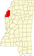
| County | Bolivar |
| Elevation | 128 ft (39 m) |
| Time zone | UTC-6 (Central (CST)) |
| • Summer (DST) | UTC-5 (CDT) |
| ZIP code | 38773 |
| Area code | 662 |
| GNIS feature ID | 668406 [1] |
Choctaw is an unincorporated community in Boliver County, Mississippi, United States. [1]